Situation Summary
Botswana remains a low-threat environment globally (composite score 4), with no confirmed significant security incidents in the past 24–48 hours and no active civil unrest, organized violence, or terrorism alerts. Risk is concentrated in urban crime hotspots—particularly Gaborone, South-East District, and Lobatse—where property crime, armed robbery, and aggravated assault drive elevated threat levels. Wildfire activity has been the dominant recent hazard signal across multiple regions, though these events do not constitute security incidents. The overall security trajectory remains stable, with structural crime risks in capital and mining-linked towns outweighing any near-term escalation indicators.
Key Developments
No confirmed significant security or unrest incidents have been reliably documented in Botswana during the last 24–48 hours (31 July–1 August 2026) across open-source news, government alerts, or African security feeds. Botswana Government official news and media coverage (Mmegi, Botswana Guardian, The Patriot, Daily News) currently lack time-certain reports for this window. The most recent documented security-related activity remains late June–early July 2026 (township tensions, serious crime cases, cross-border law-enforcement cooperation announcements), which falls outside the current 24–48-hour reporting period and cannot be presented as current developments.
Highest-Risk Areas
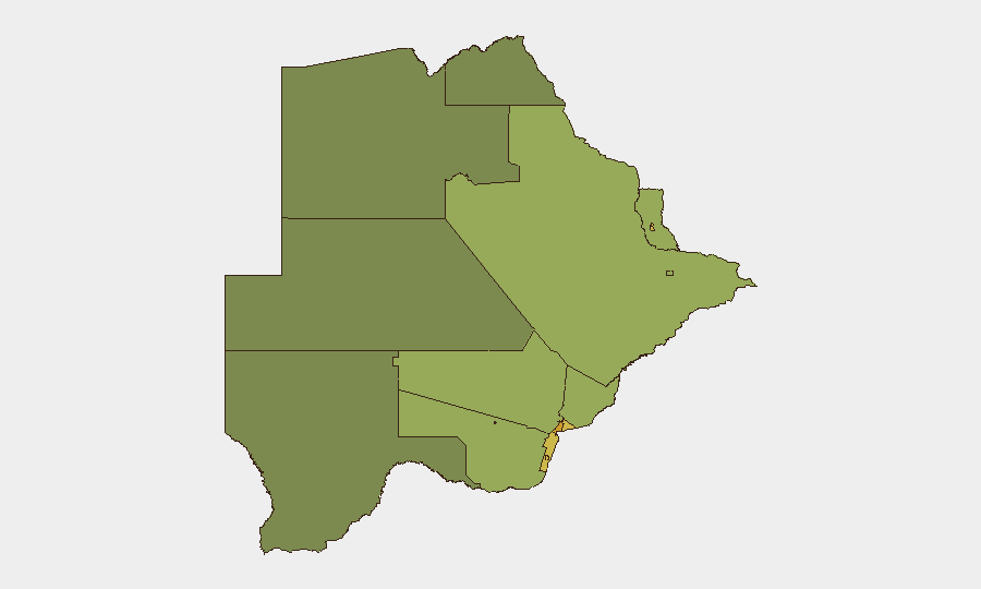
Gaborone (risk 72) dominates the threat landscape, reflecting OSAC designation of the capital as a "CRITICAL-threat location for crime" with persistent armed robbery, vehicle theft, and home invasion targeting foreign nationals and higher-income residents. South-East District (68), Lobatse (65), and Francistown (62) follow as secondary hotspots, each linked to mining activity, informal settlements, and concentrations of valuable goods or cash; Jwaneng (61) and Selebi Phikwe (58) similarly reflect mining-town vulnerability patterns. Central, North-West, and North-East districts show significantly lower composite scores (42, 38, 45 respectively), consistent with rural and lower-population-density profiles. Urban crime concentration—not political instability, insurgency, or regional conflict—explains the risk hierarchy.
How GeoBit Would Assist
Security teams monitoring Botswana should employ AOI Monitoring & Early Warning on Gaborone, Francistown, and Lobatse to detect emerging incidents, crowd activity, and infrastructure disruptions in real time. OSINT Fusion & Corroboration (cross-referencing local media, government notices, X/Twitter, and Telegram channels) will surface credible security events and crime patterns 24–48 hours before mainstream international coverage. GIS & Spatial Analysis linked to historical incident mapping can isolate micro-risk zones within high-threat districts and inform duty-of-care routing and asset placement decisions for personnel and operations.
7-Day Outlook
No escalating security indicators are visible for the next week. Wildfire activity may persist seasonally across northern and central regions, but does not pose direct security risk to corporate operations. Crime levels are expected to remain consistent with historical baseline; monitoring should focus on routine incident detection in Gaborone and secondary urban centers rather than anticipation of acute destabilization.
Highest-Risk Areas — Ranked
| # | State / Region | Risk |
|---|---|---|
| 1 | Gaborone | 72 |
| 2 | South-East District | 68 |
| 3 | Lobatse | 65 |
| 4 | Francistown | 62 |
| 5 | Jwaneng | 61 |
| 6 | Selebi Phikwe | 58 |
| 7 | Southern District | 55 |
| 8 | Kgatleng District | 50 |
| 9 | Kweneng District | 48 |
| 10 | North-East District | 45 |
| 11 | Central District | 42 |
| 12 | North-West District | 38 |
Sources
Previous Daily Briefs
A new Botswana brief is written every day — each with its own risk map and downloadable CSV. Here's the last week; use the calendar to go further back.
📅 Browse every day by calendar →
Highlighted days have a brief. Tap a day for that day's map & analysis, or “csv” for that day's dataset ($5).
Atlas — our AI intelligence desk — emails them this snapshot personally. Nothing else, no list.