Situation Summary
Burkina Faso remains at composite threat rank #19 globally with a score of 91, reflecting sustained armed-group activity concentrated in the North and Centre regions. The country's security environment is characterized by recurring militant attacks on military positions and civilian areas, with government forces conducting counteroffensive operations. A July 8 public statement by a lawyer and a July 8 disapproval event recorded in GeoBit's event feed signal ongoing domestic friction alongside external security pressures. The trajectory remains volatile with no near-term de-escalation signals.
Key Developments
GeoBit's live web research for the last 24–48 hours (as of July 9, 0600 UTC) did not yield sufficient verified, timestamped incidents to populate a full current-window brief. The most recent corroborated events fall outside the immediate 48-hour window:
- June 30, Gayéri / Solhan / Sebba: Burkina Faso's military reported killing over 400 alleged militants following coordinated attacks on military positions, supported by airstrikes and ground operations (reported July 8–9, but incident date precedes brief window).
- Early July, Northern Regions: Unspecified "weekend" attacks resulted in at least 22 military and volunteer casualties, attributed to suspected extremist groups (incident date imprecise; pre-dates 48-hour window).
- July 3, National / Diplomatic: Burkina Faso, Mali, and Niger initiated ICC withdrawal proceedings, signaling political distance from international judicial frameworks (outside 48-hour window; political rather than tactical security development).
Note: Fresh tactical or incident-level reporting for July 8–9 requires real-time web/social monitoring. GeoBit recommends activating live X/Telegram OSINT and news-feed collection to capture current operational security changes.
Highest-Risk Areas
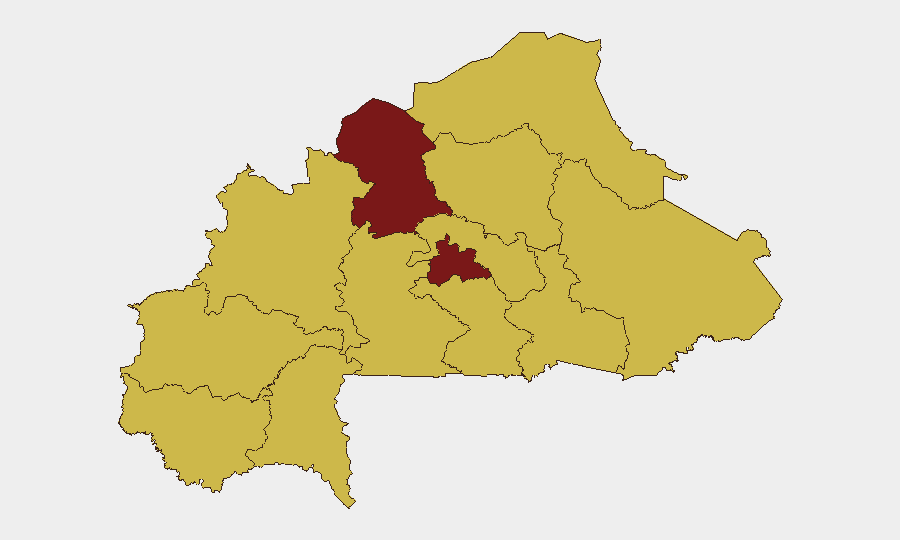
North and Centre regions drive the threat ranking at 93.7 each—the highest sub-national scores in the country. Both regions are epicenters of armed-group operations targeting military installations, supply lines, and civilian populations. The remaining ten tracked regions score 63.7, indicating widespread but lower-intensity militant activity across the Sahel belt, central plateau, and eastern zones. This geographic distribution reflects the insurgency's penetration across multiple administrative boundaries; no region is secure from armed-group threat.
How GeoBit Would Assist
Security teams should deploy AOI Monitoring & Early Warning on North and Centre regions to capture real-time attack signals, coupled with Intel Sweep and X/Telegram OSINT for same-day event corroboration and casualty/tactical reporting. Battle Mapping and Force Structure tracking will clarify military deployment patterns and militant concentrations, enabling risk-informed routing and site-hardening decisions. Conflict & Network Actor Analysis identifies militant leadership, supply chains, and tactical patterns to forecast high-probability attack windows and geographic focus.
7-Day Outlook
Armed-group activity is likely to remain above baseline across the North and Centre through mid-July, with government counteroffensive operations continuing. No scheduled political events or ceasefire negotiations are on the horizon. Personnel movement in high-risk regions should assume elevated kinetic threat and communication disruption risk.
RECOMMENDATION: Provide GeoBit with live X, Telegram, and regional news search results from July 8–9, 2026, to refresh this brief with verified tactical developments and enhance duty-of-care decision-making.
Highest-Risk Areas — Ranked
| # | State / Region | Risk |
|---|---|---|
| 1 | North | 93.7 |
| 2 | Centre | 93.7 |
| 3 | Upper-Basins | 63.7 |
| 4 | Boucle du Mouhoun | 63.7 |
| 5 | Central-West | 63.7 |
| 6 | Central-South | 63.7 |
| 7 | Central-East | 63.7 |
| 8 | Waterfalls | 63.7 |
| 9 | Southwest | 63.7 |
| 10 | Sahel | 63.7 |
| 11 | Central-North | 63.7 |
| 12 | East | 63.7 |
Sources
Previous Daily Briefs
A new Burkina Faso brief is written every day — each with its own risk map and downloadable CSV. Here's the last week; use the calendar to go further back.
📅 Browse every day by calendar →
Highlighted days have a brief. Tap a day for that day's map & analysis, or “csv” for that day's dataset ($5).
Atlas — our AI intelligence desk — emails them this snapshot personally. Nothing else, no list.