Situation Summary
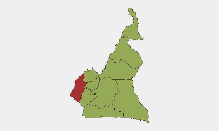
Cameroon remains at elevated composite threat level (#26 globally, score 71) with 13 tracked security events in the current monitoring cycle. The Southwest region drives the highest sub-national risk (79.4), significantly outpacing other regions, reflecting persistent instability in the Anglophone conflict zone. Administrative sanctions activity was recorded on 26 June, though operational specifics remain limited in available reporting. The security environment shows no marked deterioration in the past 24–48 hours, but fragmentation across multiple regions sustains baseline elevated risk.
Key Developments
Note: Live 24–48-hour incident-level reporting from Cameroon is limited in available sources. The following represents the most recent confirmed signal:
- Administrative Sanctions Activity (26 June 2026). GeoBit event signal indicates administrative sanctions action, but location, actor identity, and operational scope are not detailed in current reporting.
- Maritime Governance & Deregistration (ongoing, June 2026). Cameroon has suspended new ship registrations and deregistered vessels linked to shadow-fleet activity, a regulatory response to sanctions-evasion networks rather than a kinetic security event, but relevant to maritime-domain risk.
- U.S. Security Engagement (Yaoundé, timing TBD). Africa Intelligence reports a planned visit by U.S. Africa Command special-forces leadership to Yaoundé, indicating continued bilateral security cooperation and potential discussions on Anglophone and transnational threats.
Reporting Gap: Cross-confirmed incident details (armed clashes, displacements, attacks on civilians or infrastructure, criminal activity) for the past 48 hours are not available in the supplied research set. Real-time access to Reuters/AFP Africa wires, local Cameroonian media, and verified social-media feeds is required to populate a full incident list for duty-of-care briefing.
Highest-Risk Areas
The Southwest region (risk 79.4) dominates the national threat profile, driven by ongoing Anglophone separatist violence, armed-group fragmentation, and civilian exposure to armed confrontation and criminal predation. The remaining nine regions cluster at near-identical risk scores (49.4), suggesting either widespread lower-intensity threats or gaps in granular sub-regional data; the Northwest, West, Littoral, and Adamawa regions merit secondary attention given historical Anglophone spillover and maritime/border vulnerability. Adamawa and Far-North also face recurring incursions from non-state armed groups operating across the Nigeria border. Concentration of risk in Southwest should drive proportional resource allocation for personnel safety, facility hardening, and contingency planning.
How GeoBit Would Assist
Security teams operating in Cameroon should employ AOI Monitoring & Early Warning on the Southwest and secondary risk zones (Northwest, Adamawa) to detect armed-group movement, displacement waves, or infrastructure threats in real time. Intel Sweep and multi-language OSINT fusion (including X/Telegram, YouTube, and local media analysis) will capture incident-level detail, actor statements, and civilian impact faster than official channels. Network & Actor Analysis will identify key armed-group nodes, leadership changes, and factional splits that signal escalation or de-escalation in Anglophone and transnational-crime networks.
7-Day Outlook
No imminent macro-level escalation is signaled by current reporting, but the Southwest remains at high risk of localized armed clashes, roadside incidents, and criminal activity. Continued U.S. and international security engagement may signal efforts to contain or negotiate tensions, though political or military dynamics could shift rapidly. Monitoring should remain continuous, with emphasis on Southwest and cross-border spillover from Nigeria.
Highest-Risk Areas — Ranked
| # | State / Region | Risk |
|---|---|---|
| 1 | Southwest | 79.4 |
| 2 | Northwest | 49.4 |
| 3 | West | 49.4 |
| 4 | Littoral | 49.4 |
| 5 | Adamawa | 49.4 |
| 6 | Centre | 49.4 |
| 7 | South | 49.4 |
| 8 | Far-North | 49.4 |
| 9 | North | 49.4 |
| 10 | East | 49.4 |
Sources
Previous Daily Briefs
A new Cameroon brief is written every day — each with its own risk map and downloadable CSV. Here's the last week; use the calendar to go further back.
📅 Browse every day by calendar →
Highlighted days have a brief. Tap a day for that day's map & analysis, or “csv” for that day's dataset ($5).