Situation Summary
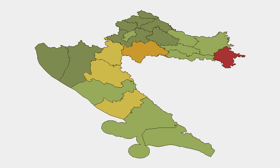
Croatia remains a low-threat environment globally (rank #129, composite score 6) but exhibits marked geographic variance, with northeastern and central regions significantly elevated above the national baseline. Recent 24–48-hour activity centers on anti-corruption enforcement and isolated violent incidents rather than systemic instability. Overall trajectory is stable, with no indicators of imminent escalation to critical levels.
Key Developments
- Zagreb, 2026-07-15: USKOK (State Attorney's Office for Organized Crime) announced arrests and urgent evidentiary actions as part of an anti-corruption operation, with investigative units conducting coordinated enforcement activity.[1]
- Tisno, 2026-07-15: Dario Šimić arrested in connection with an ongoing anti-corruption probe, signaling continuation of high-level integrity investigations across central Croatia.[5]
- Medulin (Istria), 2026-07-14: Police detained a 54-year-old North Macedonian national following an alleged knife attack and light injury to a 48-year-old Serbian national aboard a boat; suspect remains in investigative detention.[2]
- Korčula, ongoing (as of 2026-07-15): Wildfire response continues with firefighting operations and Canadair aerial support; smoke persists in surrounding areas, presenting localized hazard and resource demand.[4]
- Southern Croatia, 2026-07-15: Police conducting "Vozi sigurno, stigni sigurno" road-safety campaign targeting driver-fatigue accidents, indicating elevated concern over transport-corridor incidents during peak summer travel season.[3]
Highest-Risk Areas
Northeastern and east-central counties—Vukovar-Srijem (78), Sisak-Moslavina (72), Karlovac (68), and Lika-Senj (65)—drive the national risk profile and substantially exceed Zagreb's score (50). These regions reflect residual factors including border proximity, post-conflict legacy infrastructure vulnerabilities, and ongoing cross-border criminality patterns. Coastal and island zones (Zadar, Šibenik-Knin, Split-Dalmatia) remain moderately elevated but secondary; Zagreb and western areas remain lowest-risk. Organizations with operations in the northeast should apply heightened asset-protection and personnel-movement protocols.
How GeoBit Would Assist
Teams with people or assets in Croatia would employ OSINT fusion & corroboration and multi-language search to track anti-corruption investigations and ministerial statements in real time, detecting early signals of enforcement escalation or policy shifts. AOI monitoring & early-warning capabilities would persistently watch high-risk northeastern counties for cross-border crime indicators, trafficking activity, and localized violence, triggering alerts on material threshold breaches. Routing & network analysis would support duty-of-care teams in real-time journey planning, particularly for southern road corridors during the wildfire and summer-travel period, and would flag alternative routes around enforcement operations in Zagreb and Tisno.
7-Day Outlook
Anti-corruption enforcement is likely to remain active and visible, particularly within government and state-owned sectors, reflecting broader EU-alignment pressures. Northeastern border zones will continue to experience routine cross-border incidents and petty criminality without indication of organized escalation. Wildfire and summer-travel hazards will persist through at least mid-week; no material deterioration in the national security posture is anticipated.
Highest-Risk Areas — Ranked
| # | State / Region | Risk |
|---|---|---|
| 1 | Vukovar-Srijem County | 78 |
| 2 | Sisak-Moslavina County | 72 |
| 3 | Karlovac County | 68 |
| 4 | Lika-Senj County | 65 |
| 5 | Šibenik-Knin County | 62 |
| 6 | Brod-Posavina County | 58 |
| 7 | Zadar County | 55 |
| 8 | Osijek-Baranja County | 52 |
| 9 | City of Zagreb | 50 |
| 10 | Split-Dalmatia County | 48 |
| 11 | Požega-Slavonia County | 45 |
| 12 | Virovitica-Podravina County | 42 |
Sources
Previous Daily Briefs
A new Croatia brief is written every day — each with its own risk map and downloadable CSV. Here's the last week; use the calendar to go further back.
📅 Browse every day by calendar →
Highlighted days have a brief. Tap a day for that day's map & analysis, or “csv” for that day's dataset ($5).
Atlas — our AI intelligence desk — emails them this snapshot personally. Nothing else, no list.