Situation Summary
Cyprus remains in a low-threat environment with no credible reports of major security incidents, civil unrest, or infrastructure disruption in the last 24–48 hours. Routine police operations across urban centres have yielded multiple arrests for drug possession, vehicle arson, immigration violations, and traffic offences, reflecting standard law-enforcement activity rather than emerging instability. Political and diplomatic statements from regional actors (Israel, Turkey, Cyprus) on 28–30 July have not translated into operational security events on the island. The security posture is stable, though concentrated police activity and ongoing border/immigration enforcement underscore endemic crime and migration pressures in key urban areas.
Key Developments
- Limassol, Wednesday 29 July – A 23-year-old food delivery rider was robbed and assaulted; police treated the incident as isolated street crime with no indication of wider unrest or organized criminal activity.
- Island-wide, Wednesday night 29 July – Coordinated police crime-prevention operations across Cyprus resulted in 13 arrests (vehicle arson, drug possession, knife carrying, forged documents, counterfeit currency) and checks of ~680 drivers, 227 passengers, and 42 premises across urban hotspots.
- Island-wide, Tuesday–Wednesday night 28–29 July – Separate overnight enforcement operations produced 10 arrests and 337 traffic citations, plus additional roundups totalling 12 arrests for drunkenness, public insult, offensive instruments, drug possession, illegal stay, theft, and assault.
- Nicosia and Larnaca, Wednesday 29 July – The Aliens and Immigration Service arrested 19 individuals for illegal stay, with enforcement focused along the Green Line; increased checkpoint activity likely in these areas.
- Cyprus (national), through 30 July – No credible incidents of terrorism, civil unrest, political violence, or major infrastructure disruption confirmed by multi-source monitoring and OSINT fusion in the 24–48-hour window.
- Regional statements, 28–30 July – Israeli, Turkish, and Cypriot official statements and disapprovals recorded; no military activity, port closures, or asset seizures affecting Cyprus operations reported.
Highest-Risk Areas
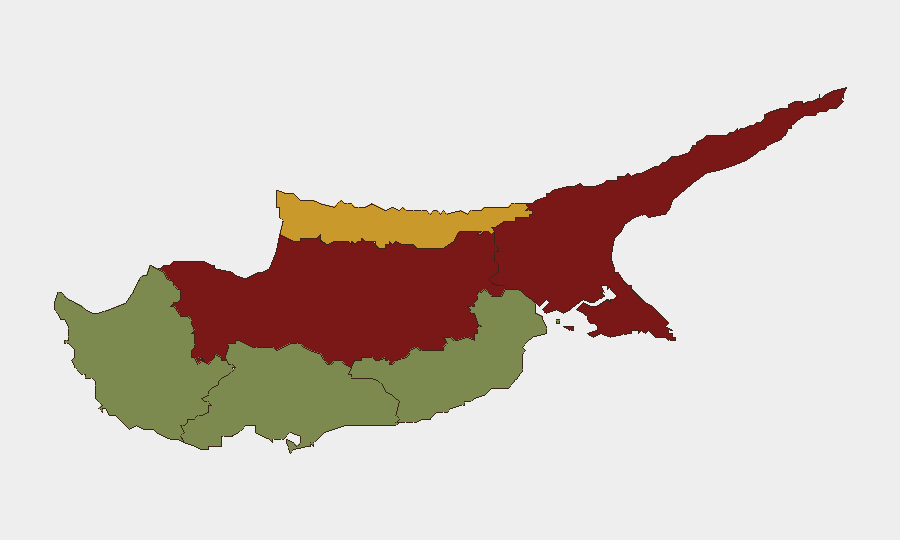
Nicosia (risk 92) and Famagusta (risk 88) drive the island's risk profile, reflecting proximity to the Green Line buffer zone, higher immigration/smuggling activity, and concentrated urban crime. Kyrenia (72) remains moderately elevated for similar reasons. Larnaca, Limassol, and Paphos register significantly lower risk (28, 22, 18 respectively), though all three remain subject to routine crime and police enforcement. The risk gradient correlates with distance from the dividing line and density of irregular migration routes rather than active conflict or political instability.
How GeoBit Would Assist
Security teams monitoring Cyprus should deploy AOI (Area-of-Interest) Monitoring & Early Warning on Nicosia and Famagusta to track police activity, protest indicators, and Green Line crossing events in real time. Intel Sweep and multi-language OSINT (X, Telegram, local news sources) provide daily corroboration of crime trends, immigration enforcement, and political statements without reliance on formal channels. Routing & Network Analysis enables duty-of-care teams to identify safe travel corridors and alternative routes in high-risk urban centres during heightened police operations.
7-Day Outlook
No escalation of security risk is anticipated over the next seven days; current police operations reflect seasonal or routine enforcement cycles. Diplomatic rhetoric from regional actors will likely continue but has not historically precedes imminent operational threats to the island. Personnel and asset security protocols should remain standard, with heightened awareness for petty crime in Nicosia and Famagusta urban centres.
Highest-Risk Areas — Ranked
| # | State / Region | Risk |
|---|---|---|
| 1 | Nicosia | 92 |
| 2 | Famagusta | 88 |
| 3 | Kyrenia | 72 |
| 4 | Larnaca | 28 |
| 5 | Limassol | 22 |
| 6 | Paphos | 18 |
Sources
Previous Daily Briefs
A new Cyprus brief is written every day — each with its own risk map and downloadable CSV. Here's the last week; use the calendar to go further back.
📅 Browse every day by calendar →
Highlighted days have a brief. Tap a day for that day's map & analysis, or “csv” for that day's dataset ($5).
Atlas — our AI intelligence desk — emails them this snapshot personally. Nothing else, no list.