Situation Summary
Dominican Republic remains a moderate-threat environment (rank #68 globally, composite score 18) with acute safety and operational disruptions emerging in the last 48 hours. Four concurrent incidents—a fatal aviation crash, a deadly resort fire, migrant-smuggling interdictions, and cargo seizures—indicate elevated operational risk in eastern provinces, particularly La Romana and La Altagracia. Sub-national risk concentration in Santo Domingo, Nacional District, and San Cristóbal drives the national profile; the eastern corridor shows acute incident clustering. The security posture is stable but operationally volatile in high-traffic tourism and border-transit zones.
Key Developments
- La Romana, 10 July – Private jet crashed during emergency landing, killing both crew members. Aviation authorities opened investigation; cause unknown. Affects airfield operations and corporate flight routing in eastern Dominican Republic.
- Bayahibe, La Altagracia Province, 10 July – Large resort-area fire killed one Italian tourist and forced evacuation of 1,700+ people from hotels and commercial structures. Fire containment took several hours; ongoing disruption to tourism zone operations and local hotel occupancy.
- La Romana–Bayahibe corridor, 10 July – Dominican Army intercepted two vehicles carrying 20 undocumented Haitian nationals (including 4 children) during border patrol; migrants detained for processing. Reflects ongoing smuggling-route activity and heightened military presence in the corridor.
- Maritime route (off DR coast), 9–10 July – U.S. Coast Guard cutter *Vigilant* seized go-fast vessel smuggling ~7,800 lbs of cargo from Haiti to Dominican Republic in coordination with Dominican maritime authorities. Anti-smuggling coordination active; maritime border enforcement elevated.
- Eastern DR Army patrol zone, 10 July – Social media video documented Dominican Army personnel conducting armed stop-and-search of suspected smuggling vehicles; occupants placed under arrest. Consistent with migrant-smuggling interception reports; illustrates enforcement intensity in border-adjacent roads.
Highest-Risk Areas
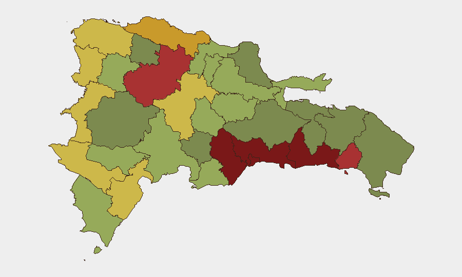
Santo Domingo (risk 92) and Nacional District (risk 88) dominate the national risk profile, reflecting urban crime, organized-crime presence, and gang activity concentrated in the capital corridor—a persistent baseline risk. San Cristóbal (85), San Pedro de Macorís (83), and La Romana (78) form a secondary eastern cluster; La Romana's recent incident surge (aviation crash, resort fire, migrant interdictions) elevates acute operational risk there despite a composite score below the capital. Santiago (76) and Puerto Plata (72) represent northern commercial and tourism hubs with moderate structural risk. Eastern provinces (La Romana, La Altagracia, San Pedro de Macorís) are now experiencing acute incident clustering and should be treated as elevated-risk zones for the immediate 7-day window.
How GeoBit Would Assist
Teams with personnel or assets in Dominican Republic should deploy AOI Monitoring & Early Warning on La Romana, Bayahibe, and Santiago to track incident frequency and patterns in real time. Maritime & Aviation Tracking coupled with OSINT fusion (X/Twitter, local media, radio SIGINT) enables rapid detection of disruptions—crashes, fires, smuggling interdictions—that affect supply chains and staff mobility. Routing & Network Analysis can provide alternative ground and air routes around La Romana and Bayahibe in the near term to bypass operational disruption zones.
7-Day Outlook
The cluster of incidents in the eastern corridor (La Romana, La Altagracia) is likely to sustain elevated law-enforcement and military activity, increasing checkpoint density and road delays for 3–7 days. Resort and tourism operations in Bayahibe will face reduced capacity and staff attrition during fire recovery; supply-chain timing to and from the eastern tourist zone should be extended. No indicators suggest escalation beyond acute incident response; baseline risk in Santo Domingo and Nacional District remains unchanged.
Highest-Risk Areas — Ranked
| # | State / Region | Risk |
|---|---|---|
| 1 | Santo Domingo | 92 |
| 2 | Nacional District | 88 |
| 3 | San Cristóbal | 85 |
| 4 | San Pedro de Macorís | 83 |
| 5 | La Romana | 78 |
| 6 | Santiago | 76 |
| 7 | Puerto Plata | 72 |
| 8 | Elías Piña | 70 |
| 9 | Dajabón | 68 |
| 10 | Barahona | 65 |
| 11 | Independencia Province | 64 |
| 12 | La Vega | 62 |
Sources
Previous Daily Briefs
A new Dominican Republic brief is written every day — each with its own risk map and downloadable CSV. Here's the last week; use the calendar to go further back.
📅 Browse every day by calendar →
Highlighted days have a brief. Tap a day for that day's map & analysis, or “csv” for that day's dataset ($5).
Atlas — our AI intelligence desk — emails them this snapshot personally. Nothing else, no list.