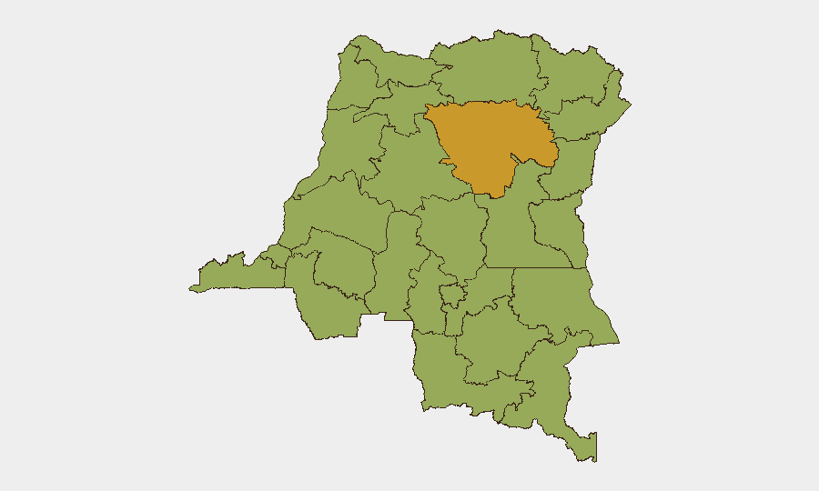
Situation Summary
DR Congo remains in a state of chronic instability driven by active civil conflict, armed-group operations, and endemic crime, with a composite national threat score of 63 (rank #34 globally). The security environment is characterized by persistent rather than acute deterioration; no major new incidents have been time-stamped and verified in the past 24–48 hours, but baseline risk across multiple provinces—particularly Tshopo, North Kivu, Kinshasa, and the eastern conflict zone—remains elevated. An active Ebola outbreak in Ituri (782 confirmed cases as of 13 June) compounds operational and duty-of-care risks. The trajectory suggests sustained instability without immediate signs of regional escalation or sudden-onset crisis.
Key Developments
- No discrete security incidents with confirmed timestamps from the last 24–48 hours have been validated across open-source and social-media monitoring. Armed-group activity in North Kivu and Tshopo continues at established operational baseline, but without newly documented clashes, displacement events, or cross-border incursions in this window.
- Kinshasa urban-crime and civil-unrest risk remains persistently elevated, though no specific incident has been corroborated in verified reporting for 15–16 June. Gang activity, robbery, and protest-related disruptions remain a fixture of the operating environment.
- Eastern-provinces armed-group operations (North Kivu, Tshopo, Ituri) show continuity of threat rather than new developments. Reporting reflects ongoing risk management rather than fresh tactical events in the last 48 hours.
- Ituri Ebola outbreak continues as a public-health and operational constraint (782 confirmed cases, 181 deaths as of 13 June). While this data point lies slightly outside the 24–48-hour window, it remains an active driver of access restrictions, medical risk, and staffing challenges for corporate operations.
- Border-zone instability persists in Sud-Ubangi and Nord-Ubangi linked to regional conflicts, but no new cross-border incursions or major displacement events have been time-stamped in the recent window.
Highest-Risk Areas
Tshopo (72.9) and a cluster of four provinces tied at 57.9—North Kivu, Kinshasa, Haut-Lomami, and South Kivu—drive the national threat profile. Tshopo's elevated score reflects ongoing armed-group activity in the central-eastern region; North Kivu and South Kivu remain epicenters of the broader civil conflict and militia operations. Kinshasa's risk, despite its political-capital status, reflects high urban crime, gang activity, and potential civil unrest. Haut-Lomami adds risk from armed-group presence and criminality. A second tier of provinces (Maniema, Équateur, border regions) maintains moderate-to-high risk (42.9) from conflict spillover and cross-border instability.
How GeoBit Would Assist
Security and risk teams with personnel or assets in DR Congo should deploy AOI Monitoring & Early Warning on high-risk provinces (Tshopo, North Kivu, Kinshasa) to detect onset of clashes, displacement, or crime spikes with near-real-time alerting. Intel Sweep and multi-language OSINT fusion (X, Telegram, local media) provide continuous corroboration of armed-group movements and urban-crime patterns. GIS & Spatial Analysis and Routing & Network Analysis support alternative travel planning and facility-security assessment in zones where risk is acute.
7-Day Outlook
No immediate signs of sudden escalation are present; the conflict appears to be in a phase of managed, ongoing tension. However, any shifts in armed-group positioning, cross-border military activity, or major urban unrest in Kinshasa or eastern cities could emerge rapidly. Teams should maintain heightened situational awareness and pre-positioned contingency protocols for evacuation or relocation.
Highest-Risk Areas — Ranked
| # | State / Region | Risk |
|---|---|---|
| 1 | Tshopo | 72.9 |
| 2 | North Kivu | 57.9 |
| 3 | Kinshasa | 57.9 |
| 4 | Haut-Lomami | 57.9 |
| 5 | South Kivu | 57.9 |
| 6 | Maniema | 42.9 |
| 7 | Sud-Ubangi | 42.9 |
| 8 | Équateur | 42.9 |
| 9 | Nord-Ubangi | 42.9 |
| 10 | Mongala | 42.9 |
| 11 | Lower Uele | 42.9 |
| 12 | Tshuapa | 42.9 |
Sources
Previous Daily Briefs
A new DR Congo brief is written every day — each with its own risk map and downloadable CSV. Here's the last week; use the calendar to go further back.
📅 Browse every day by calendar →
Highlighted days have a brief. Tap a day for that day's map & analysis, or “csv” for that day's dataset ($5).