Situation Summary
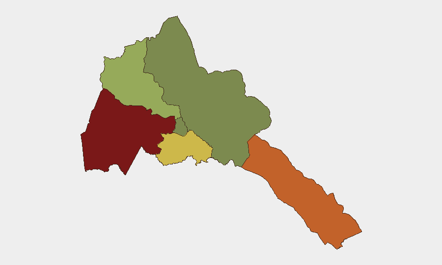
Eritrea remains a low-frequency threat environment globally (composite score 24; no tracked events recorded) with heavily concentrated risk in its western and southern border regions. Sub-national variance is extreme: Gash-Barka (risk 92) and Southern Red Sea Region (risk 75) dominate the threat landscape, while the capital region of Maekel (risk 18) and Northern Red Sea (risk 0) present minimal exposure. A flagged unconventional-violence signal linked to Eritrea–Canada interaction on 24 July 2026 warrants monitoring but lacks detailed corroboration in available open sources.
Key Developments
- 24 July 2026 · Unconventional Violence Signal · Eritrea–Canada: GeoBit platform flagged an unconventional-violence event involving Eritrea and Canada on this date. Source verification and incident specifics remain under review; no location or casualty data available from current web research. Corporate teams with Canadian or dual nationals in-country should confirm staff welfare.
- No additional verified incidents reported in last 24–48 hours: Live web research (news, social media, broadcast) did not yield location-specific security or infrastructure events in Eritrea during this window. Regional context (Ethiopia–Eritrea military dynamics, Tigray-related analysis) remains fluid but not current acute incidents.
Highest-Risk Areas
Gash-Barka region (western border) and Southern Red Sea Region drive Eritrea's internal threat distribution, reflecting historical cross-border instability, resource competition, and limited state presence. Both regions score well above the national mean and warrant priority for duty-of-care and asset-protection teams. Debub Region (risk 68) presents moderate elevation, likely tied to southern border dynamics and pastoral/nomadic security vulnerabilities. By contrast, Maekel (capital) and Northern Red Sea remain low-risk, suggesting urban security and northern coastal areas are substantially more stable for personnel deployment and operations.
How GeoBit Would Assist
Intel Sweep & OSINT Fusion across X/Twitter, Telegram, YouTube, and multi-language sources can establish persistent monitoring of Gash-Barka and Southern Red Sea activity, filling gaps in commercial news coverage and enabling early detection of cross-border incidents, military movement, or intercommunal tensions. AOI Monitoring & Early Warning with satellite and radio SIGINT can track persistent activity in high-risk zones and alert duty teams to emerging threats before escalation. Network & Actor Analysis can map armed groups, smuggling networks, and regime-stability indicators to assess risk to specific corporate assets or personnel operating in border regions.
7-Day Outlook
No acute escalation is anticipated in the near term, though the unverified Eritrea–Canada signal on 24 July may clarify in coming days as source material surfaces. Gash-Barka and Southern Red Sea regions should be assumed to retain chronic instability; personnel travel to or through these areas should remain under heightened scrutiny. Corporate security teams are advised to confirm staff status, verify communication protocols, and maintain liaison with diplomatic missions pending further detail on the flagged unconventional-violence event.
Highest-Risk Areas — Ranked
| # | State / Region | Risk |
|---|---|---|
| 1 | Gash-Barka | 92 |
| 2 | Southern Red Sea Region | 75 |
| 3 | Debub Region | 68 |
| 4 | Anseba | 55 |
| 5 | Maekel Region | 18 |
| 6 | Northen Red Sea Region | 0 |
Sources
Previous Daily Briefs
A new Eritrea brief is written every day — each with its own risk map and downloadable CSV. Here's the last week; use the calendar to go further back.
📅 Browse every day by calendar →
Highlighted days have a brief. Tap a day for that day's map & analysis, or “csv” for that day's dataset ($5).
Atlas — our AI intelligence desk — emails them this snapshot personally. Nothing else, no list.