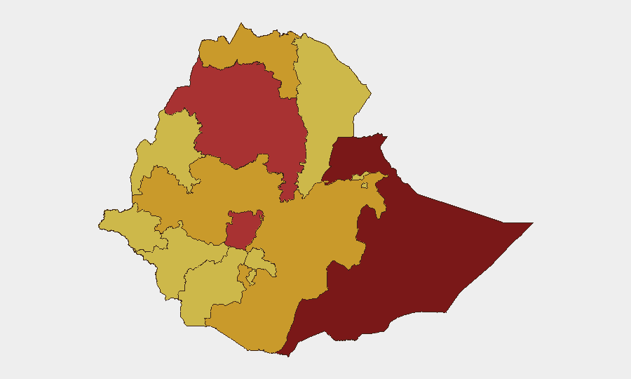
Situation Summary
Ethiopia remains fractured along regional and ethnic lines, with civil conflict the primary driver of a composite threat score of 100—the sixth-highest globally. Military clashes between Ethiopian federal forces and regional militias, combined with persistent civil unrest (protests, strikes, public dissent), have generated 241 tracked events. The security environment shows no signs of stabilization; rather, signals from the last 72 hours point to widening tensions across multiple fronts—agriculture policy disputes, airline operations, financial-sector activity, and renewed conventional military engagement in at least two distinct theaters.
Key Developments
- 2026-06-21 | Conventional Military Engagement: Ethiopian military forces engaged with militia units; location and casualty figures not confirmed in available signals. This represents continued kinetic activity outside the established war zones and warrants tactical clarification.
- 2026-06-21 | Business Sector Threat: A direct threat targeting a business entity was issued; nature, perpetrator, and specific sector remain unconfirmed. Corporate operations are increasingly cited in conflict-adjacent activity.
- 2026-06-23 | Residents vs. Islamic Groups: Conventional military-style confrontation reported between residents and an Islamic militant faction. Geographic specificity is absent; this may indicate dispersed activity or poor reporting.
- 2026-06-22 | Regional Political Backlash: Representatives issued disapproval statements directed at Amhara Region, signaling widening political fracture and possible coordination of federal or inter-regional pressure.
- 2026-06-23 | Civil Unrest Signals: Multiple public statements from students, voters, and academic staff expressing disapproval of government actions. Collectively, these suggest organized or spontaneous dissent in urban centers, likely Addis Ababa or regional capitals.
- 2026-06-21 | Airline Operations: An airline operator issued disapproval toward African counterparts—possibly a logistics, regulatory, or safety concern. This may indicate constraints on movement or commerce.
Data Quality Note: Recent event signals are event-type and actor-type identifications; specific locations, casualty counts, and confirmed incident details are not available in current feeds. Cross-referencing with real-time news sources (Reuters, AFP, Al Jazeera, Addis Standard) is essential for operational decision-making.
Highest-Risk Areas
Somali Region (risk 100) and Amhara Region (risk 79.3) are the primary drivers of national risk, followed closely by Central Ethiopia Regional State (76.9), Oromia (72), and Tigray (71.5). Somali Region's maximum score reflects ongoing clan-based and cross-border militant activity; Amhara's elevated score reflects the intersection of militia mobilization, federal military operations, and political-administrative collapse. Central Ethiopia, Oromia, and Tigray each sustain active conflict nodes involving regional forces, federal troops, and armed opposition groups. Even Addis Ababa (70.5) carries substantial risk, driven by protest activity, political tension, and security-force responses.
How GeoBit Would Assist
Security and duty-of-care teams should deploy AOI Monitoring & Early Warning on critical facilities and routes within Addis Ababa, Amhara, and Somali Region to detect movement, access changes, and emerging checkpoints in near-real time. OSINT fusion (X/Twitter, Telegram, local media, radio SIGINT) across Amharic and Afaan Oromo channels will surface grassroots conflict signals—roadblocks, clashes, displacement—before mainstream wires report them. Routing & Network Analysis ensures personnel and supply chains avoid active conflict zones and militia roadblocks with daily updates.
7-Day Outlook
Federal-militia clashes are likely to persist or intensify in Amhara and Somali Region; Addis Ababa civil unrest may escalate if government policy announcements provoke organized student or labor responses. No major peace talks or ceasefires are signaled. Organizations with operations in these zones should anticipate access constraints, movement delays, and potential security incidents affecting staff and assets.
Highest-Risk Areas — Ranked
| # | State / Region | Risk |
|---|---|---|
| 1 | Somali Region | 100 |
| 2 | Amhara Region | 79.3 |
| 3 | Central Ethiopia Regional State | 76.9 |
| 4 | Oromia Region | 72 |
| 5 | Tigray | 71.5 |
| 6 | Addis Ababa | 70.5 |
| 7 | Afar Region | 70 |
| 8 | Benishangul-Gumuz Region | 70 |
| 9 | Gambela Region | 70 |
| 10 | South West Ethiopia Peoples | 70 |
| 11 | South Ethiopia Regional State | 70 |
| 12 | Sidama | 70 |
Sources
Previous Daily Briefs
A new Ethiopia brief is written every day — each with its own risk map and downloadable CSV. Here's the last week; use the calendar to go further back.
📅 Browse every day by calendar →
Highlighted days have a brief. Tap a day for that day's map & analysis, or “csv” for that day's dataset ($5).