Situation Summary
France remains at moderate composite risk (rank #45 globally; score 39) with 211 tracked events, but faces a concentrated threat footprint in Nouvelle-Aquitaine (score 57) and elevated cyber/incident activity across northern and eastern regions. Recent 24–48-hour developments include a civilian aircraft crash in Meurthe-et-Moselle, a national statistics-office data breach affecting 12,800 employees, and severe weather causing casualties at outdoor gatherings. No large-scale civil unrest or terror incidents have been confirmed in open sources; the threat environment remains fragmented across regional, cyber, and weather-related vectors rather than systemic.
Key Developments
- Tomblaine, Meurthe-et-Moselle (June 28, 2026) – Civilian skydiving aircraft crashed near Nancy, killing 11 people. Police have cordoned the area and advised strict avoidance; localized emergency response and airspace disruption ongoing.
- INSEE Cyberattack (June 28, 2026) – France's national statistics office confirmed breach of staff directory containing identifiers and contact details for approximately 12,800 current and former employees. Banking data and passwords reportedly unaffected; heightened risk of targeted phishing against affected personnel.
- Severe Weather & Festival Evacuation (June 27–28, 2026) – Storms with rain, hail, and lightning struck multiple French regions overnight, resulting in at least 1 death and 15 injuries (2 serious). At least one music festival was evacuated due to equipment damage and safety risks.
- Authorities Investigation Signal (June 29, 2026) – GEOBIT event feed flagged an active "Investigate" incident involving French authorities; specific details and location remain under clarification.
- Regional Unrest Indicators (June 27, 2026) – Multiple low-level signals recorded: prison-related disapproval, property seizure by municipal authorities, extremist threats, and community disapproval. No confirmed large-scale mobilization; events remain localized and fragmented.
Highest-Risk Areas
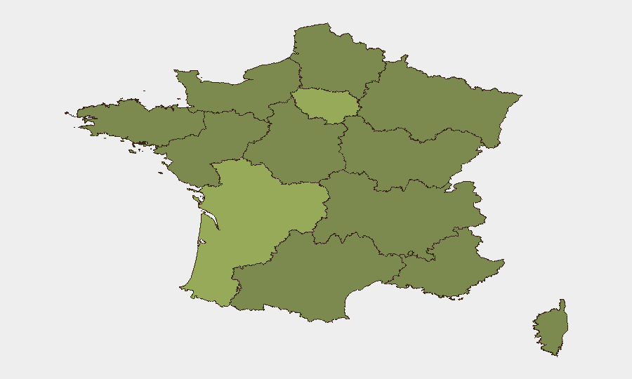
Nouvelle-Aquitaine (southwest; score 57) substantially outranks all other regions and is the primary driver of national risk, though specific recent incidents are not yet fully attributed. Île-de-France (Paris metropolitan area; score 43.6) remains the second-highest-risk zone—typical for capital-region concentration of political, cyber, and event-security exposure. The northern and eastern belt (Hauts-de-France, Grand Est, Normandy, Bourgogne–Franche-Comté) each score 27–27.1, reflecting distributed low-level incidents rather than acute crises. Risk across these regions appears event-driven (weather, transport, labor, or protest-related) rather than indicative of sustained conflict or instability.
How GeoBit Would Assist
Intel Sweep and multi-language OSINT fusion enable continuous monitoring of French media, social platforms, and official statements to distinguish routine incidents from escalating threats. AOI Monitoring & Early Warning with persistent watch over Nouvelle-Aquitaine, Île-de-France, and transport/event venues provides alerting before incidents affect corporate operations or personnel. GIS & Spatial Analysis combined with routing & network analysis allows security teams to update travel corridors and facility access in real time, particularly around Tomblaine airspace restrictions and storm-affected transport zones.
7-Day Outlook
Weather impacts should subside within 48 hours; recovery at affected festival venues and transport corridors is expected to normalize by early July. The INSEE breach and related phishing risk will persist as a background concern for staff and partners with compromised directory entries; heightened email-security vigilance is warranted. Regional signals remain fragmented; no escalation to nationwide unrest is presently indicated, though Nouvelle-Aquitaine and event-security monitoring should remain active through the weekend.
Highest-Risk Areas — Ranked
| # | State / Region | Risk |
|---|---|---|
| 1 | Nouvelle-Aquitaine | 57 |
| 2 | Ile-de-France | 43.6 |
| 3 | Auvergne-Rhône-Alpes | 27.6 |
| 4 | Normandy | 27.1 |
| 5 | Hauts-de-France | 27.1 |
| 6 | Grand Est | 27.1 |
| 7 | Pays de la Loire | 27.1 |
| 8 | Occitania | 27.1 |
| 9 | Provence-Alpes-Côte d'Azur | 27.1 |
| 10 | Brittany | 26.9 |
| 11 | Centre-Val de Loire | 26.9 |
| 12 | Bourgogne – Franche-Comté | 26.9 |
Sources
Previous Daily Briefs
A new France brief is written every day — each with its own risk map and downloadable CSV. Here's the last week; use the calendar to go further back.
📅 Browse every day by calendar →
Highlighted days have a brief. Tap a day for that day's map & analysis, or “csv” for that day's dataset ($5).