Situation Summary
Guinea-Bissau remains operationally stable with no verifiable security incidents, armed conflict, civil unrest, or travel disruptions recorded in the past 24–48 hours. The broader regional environment continues to experience military and security operations in neighboring states (Guinea, Mali, Niger), but open-source monitoring confirms no concrete spillover activity, refugee movements, or armed incursions on Guinea-Bissau soil in the current window. Routine ECOWAS stabilization mission activities (including Nigerian troop rotations) remain consistent with pre-existing mandate operations and are not indicative of escalation. The country's threat trajectory remains flat absent new incident reporting.
Key Developments
No discrete, verifiable security or travel-risk incidents meeting incident-level specificity and temporal precision standards have been identified in Guinea-Bissau during the last 24–48 hours. Open-source monitoring—including news outlets, specialized security feeds, and social-media platforms—has not corroborated any dated incidents of armed confrontation, political instability, organized crime activity, or major civil unrest within the country during this window. Routine ECOWAS mission logistics (airlifts, personnel rotations) continue as part of standing operations and are not tied to any newly reported security development in-country. No refugee flows, cross-border incursions, or organized-crime spillover from neighboring instability have been documented on Guinea-Bissau territory in the past 48 hours. Unconfirmed social-media claims referencing military activity lack publication dates, source attribution, and independent corroboration and therefore cannot be assessed as current or actionable developments.
Highest-Risk Areas
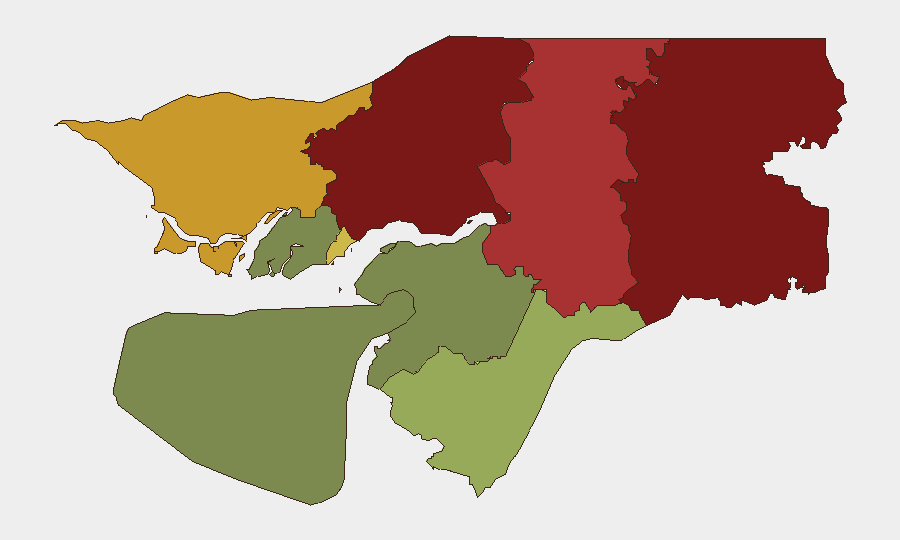
Gabu Region (risk score 92) and Oio Region (risk score 85) remain the highest-risk sub-national areas, followed by Bafatá (78) and Cacheu (72). These northeastern and northern regions likely reflect cumulative exposure to cross-border dynamics with Guinea and Mali, where armed groups and military operations are active, as well as long-standing vulnerabilities to trafficking, informal armed activity, and weak state presence. Bissau Autonomous Sector (68) ranks fifth, consistent with its status as the capital and primary hub for political, economic, and security activity. Southern and central regions (Tombali, Quinara, Biombo, Bolama) show substantially lower risk profiles, reflecting reduced exposure to border instability and lower concentration of organized activity.
How GeoBit Would Assist
Security teams managing personnel or assets in Guinea-Bissau should employ AOI Monitoring & Early Warning on high-risk northern and northeastern regions (Gabu, Oio, Bafatá, Cacheu) to detect spillover from neighboring conflicts in near-real time. Intel Sweep, multi-language OSINT, and entity extraction capabilities enable continuous monitoring of local media, social platforms, and security feeds to corroborate rumors and distinguish signal from noise—essential in an environment where unconfirmed claims circulate but verifiable incidents remain sparse. Routing & Network Analysis and GIS & Spatial Analysis support duty-of-care planning, allowing teams to identify safe transit corridors and assess exposure by location and activity type.
7-Day Outlook
No significant security deterioration is forecast for the next seven days absent new cross-border spillover or political instability. Routine ECOWAS operations are expected to continue. Monitoring should remain focused on northern regions and any shifts in neighboring Mali, Guinea, or regional military posture that might signal emerging threats to Guinea-Bissau's stability.
Highest-Risk Areas — Ranked
| # | State / Region | Risk |
|---|---|---|
| 1 | Gabu Region | 92 |
| 2 | Oio Region | 85 |
| 3 | Bafatá Region | 78 |
| 4 | Cacheu Region | 72 |
| 5 | Bissau Autonomous Sector | 68 |
| 6 | Tombali Region | 45 |
| 7 | Quinara Region | 38 |
| 8 | Biombo Region | 32 |
| 9 | Bolama Region | 15 |
Sources
Previous Daily Briefs
A new Guinea-Bissau brief is written every day — each with its own risk map and downloadable CSV. Here's the last week; use the calendar to go further back.
📅 Browse every day by calendar →
Highlighted days have a brief. Tap a day for that day's map & analysis, or “csv” for that day's dataset ($5).
Atlas — our AI intelligence desk — emails them this snapshot personally. Nothing else, no list.