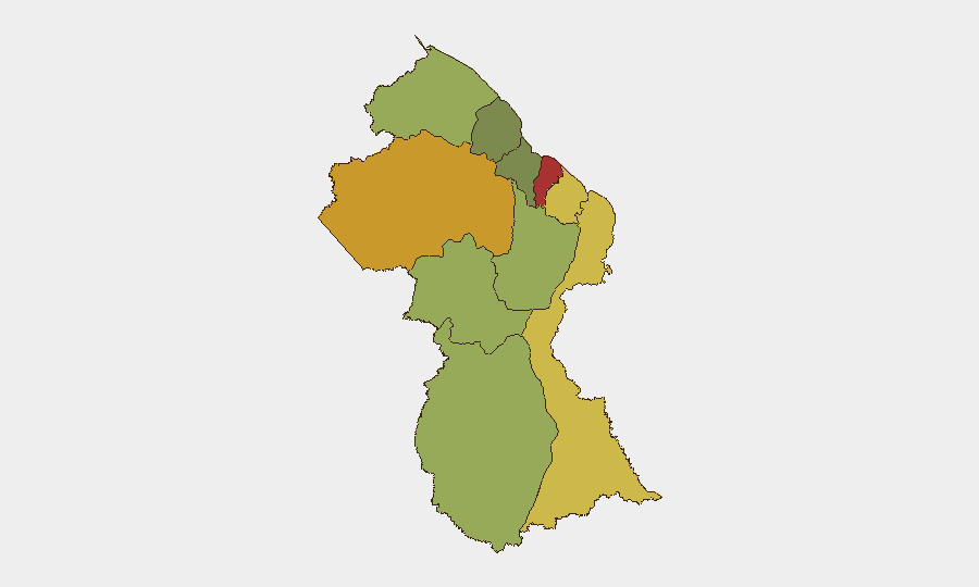
Situation Summary
Guyana remains a low-ranked global threat environment (composite score 14) but exhibits localized instability concentrated in coastal urban centers and interior mining zones. The past 48 hours have yielded five discrete security incidents—three weapons-related arrests in Georgetown, one missing military rifle under investigation, and one fatal mining dispute shooting—none of which indicate systemic breakdown or nationwide disruption. The security picture is fragmented rather than acute: criminal opportunism, inadequate weapons custody protocols, and resource-dispute violence in remote areas rather than coordinated organized crime or civil unrest.
Key Developments
- Independence Boulevard, Georgetown (4 Aug): Guyana Police arrested two men and recovered a Sig Sauer 9mm pistol with 19 live rounds during a bar operation; a 33-year-old construction worker from Alexander Village and a 41-year-old man from Providence, East Bank Demerara are in custody.
- Mandela Avenue, Georgetown (4 Aug): Police intercepted a Toyota Hilux and arrested a 31-year-old project manager from La Parfaite Harmonie after finding one .223 live round and one spent shell in the glove compartment; the driver is held at East La Penitence Police Station.
- Camp Stephenson, Timehri, East Bank Demerara (ongoing, active through 3 Aug): A GDF Corporal seconded to the base was placed under close arrest after an AK-47 rifle with loaded magazine in his custody went missing; a joint GDF–Guyana Police team from Camp Ayanganna has been deployed to locate the weapon.
- Interior mining area (4 Aug, "yesterday" reference): A 32-year-old gold miner, Ceton Mark Courtman, was shot dead by a security officer attached to a dredge following a "blai" (gold-sharing) dispute; police investigation is ongoing.
- Berbice fires (past 2 days, through 4 Aug): The Guyana Fire Service reports two homes destroyed in separate fires; one fire is suspected arson and is under investigation, the other attributed to occupant-controlled rubbish burning.
- Long Creek presidential livestock farm (ongoing, as of 4 Aug): Transparency International Guyana publicly called for an independent investigation into President Irfaan Ali's farm, citing Integrity Act concerns and potential conflicts of interest; no security incident but reflects active governance-integrity friction.
Highest-Risk Areas
Demerara-Mahaica (risk 78) and Cuyuni-Mazaruni (risk 72) lead the sub-national ranking and reflect Georgetown's concentration of urban crime, weapons trafficking, and gang-related activity. Mahaica-Berbice (65) and East Berbice-Corentyne (62) follow, driven by criminality, border-adjacent vulnerabilities, and informal settlement instability. The top-ranked regions are predominantly coastal and urban; interior mining zones (represented in the ranking by Upper Demerara-Berbice, risk 58) contribute acute but spatially dispersed violence linked to artisanal mining disputes and informal security responses. No single region shows signs of organized insurgency or political instability; risk is fragmented and reactive rather than systemic.
How GeoBit Would Assist
Teams with personnel or assets in Guyana should employ AOI Monitoring & Early Warning on high-risk coastal districts (Georgetown, Berbice towns, mining logistics hubs) to detect emerging crime clusters and weapons-movement patterns. Network & Actor Analysis would map informal security, dredge-operation hierarchies, and trafficking networks linking coastal crime to interior mining zones. Routing & Network Analysis supports duty-of-care teams in identifying safe transit corridors away from crime hotspots and designing low-exposure supply-chain and personnel movement protocols.
7-Day Outlook
No major escalation is expected over the next week; the incidents of 3–4 August appear localized and reactive rather than harbingers of coordinated unrest. Weapons-custody investigations and mining-area police responses will likely continue, with modest media attention. Political integrity friction around the presidential farm issue may persist but is unlikely to trigger acute security events in the near term.
Highest-Risk Areas — Ranked
| # | State / Region | Risk |
|---|---|---|
| 1 | Demerara-Mahaica | 78 |
| 2 | Cuyuni-Mazaruni | 72 |
| 3 | Mahaica-Berbice | 65 |
| 4 | East Berbice-Corentyne | 62 |
| 5 | Upper Demerara-Berbice | 58 |
| 6 | Potaro-Siparuni | 48 |
| 7 | Barima-Waini | 45 |
| 8 | Upper Takutu-Upper Essequibo | 42 |
| 9 | Pomeroon-Supenaam | 38 |
| 10 | Essequibo Islands | 35 |
Sources
Previous Daily Briefs
A new Guyana brief is written every day — each with its own risk map and downloadable CSV. Here's the last week; use the calendar to go further back.
📅 Browse every day by calendar →
Highlighted days have a brief. Tap a day for that day's map & analysis, or “csv” for that day's dataset ($5).
Atlas — our AI intelligence desk — emails them this snapshot personally. Nothing else, no list.