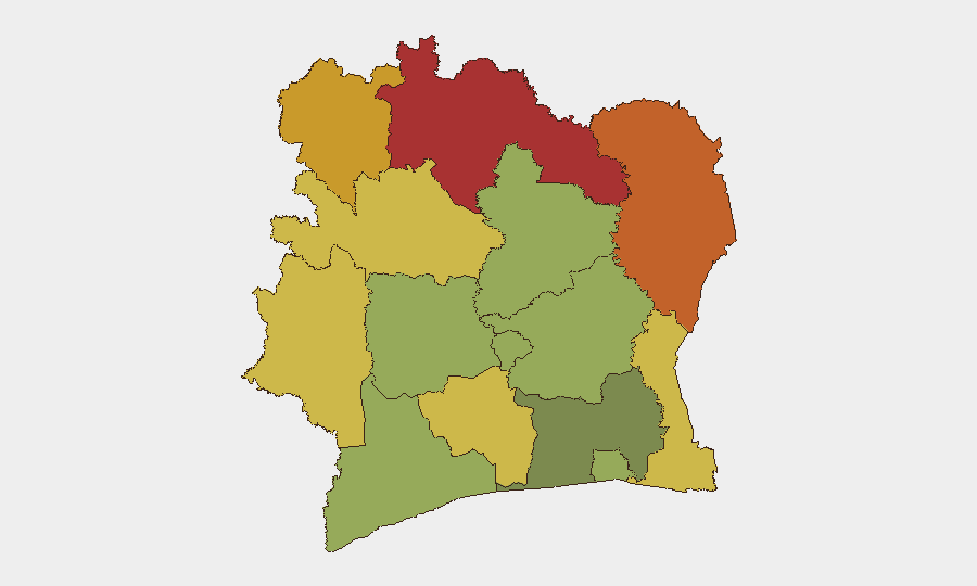
Situation Summary
Ivory Coast remains at moderate regional risk (global rank #52, composite threat score 32) with no corroborated security incidents reported in the last 24–48 hours. However, the far-northern border corridor—particularly around Kafolo (Savanes District) and Comoé National Park—continues to experience elevated militant activity and community instability linked to cross-border pressure from Burkina Faso and Mali. The security posture in the north has tightened following reported assaults on Ivorian security-force positions around 9–10 July, but the overall trajectory remains one of contained but persistent threat rather than rapid escalation.
Key Developments
- Kafolo border security reinforcement (Savanes District, 9–10 July 2026). Ivorian authorities deployed additional checkpoints and patrols following militant assaults on security-force positions near Kafolo on the Burkina Faso border. Local community protests against insecurity preceded the reinforcement, signalling civilian concern over militant infiltration and cross-border raiding.
- No discrete incidents documented (11–13 July 2026). Open-source reporting and available news feeds do not show clearly dated security or civil-unrest incidents within the last 24–48 hours. Standing terrorism and violent-crime warnings remain in effect for northern border zones, but no new event-specific incident has been corroborated in this window.
- Persistent northern border-corridor risk (Comoé District, Bouna area, ongoing). Foreign-ministry travel advisories and regional security monitors continue to flag latent terrorist and bandit activity in the far northeast, particularly near Comoé National Park and the Mali–Burkina Faso–Ivory Coast tripoint, but activity levels have not materially shifted in the last 48 hours based on available sources.
Highest-Risk Areas
Savanes, Zanzan, Denguélé, and Comoé Districts together account for the top four risk scores (78, 75, 72, and 70 respectively), all concentrated in the far north and northeast. These regions share a common driver: proximity to the Burkina Faso and Mali borders, where non-state armed groups, militant cells, and transnational crime networks operate with limited state oversight. Kafolo (in Savanes) and Bouna (in Comoé) are particular friction points. In contrast, Abidjan and the southern tier (Lacs, Bas-Sassandra) register substantially lower risk (45–52), reflecting stronger state presence and urban security infrastructure. Risk gradates by distance from the capital and by border permeability.
How GeoBit Would Assist
Corporate security and duty-of-care teams with personnel or assets in the north should employ AOI Monitoring & Early Warning on Savanes, Zanzan, and Comoé Districts, with alert thresholds set for militant activity, checkpoint incidents, and cross-border movement. OSINT Fusion & Corroboration (including X/Twitter and Telegram OSINT, multi-language news sweep, and entity extraction) would disambiguate unverified social-media reports from credible incidents, reducing false alarm and decision-lag. Border & Disputed-Territory Search and Conflict & Military (force-structure and weapons-capability tracking) capabilities enable real-time assessment of militant capacity and Ivorian response posture in the far north.
7-Day Outlook
No imminent large-scale escalation is signalled, but the 9–10 July Kafolo incidents and subsequent Ivorian reinforcement suggest a cycle of sporadic militant incursion and tactical response rather than strategic de-escalation. Security teams should expect checkpoint delays, occasional closure of northern access roads, and periodic community friction over state capacity. Monitoring of Burkina Faso militia movements and Mali-border activity remains critical to early warning in Ivory Coast's northeast.
Highest-Risk Areas — Ranked
| # | State / Region | Risk |
|---|---|---|
| 1 | Savanes District | 78 |
| 2 | Zanzan District | 75 |
| 3 | Denguélé District | 72 |
| 4 | Comoé District | 70 |
| 5 | Montagnes District | 68 |
| 6 | Woroba District | 65 |
| 7 | Gôh-Djiboua District | 60 |
| 8 | Sassandra-Marahoué District | 58 |
| 9 | Vallée du Bandama District | 55 |
| 10 | Bas-Sassandra District | 52 |
| 11 | Lacs District | 48 |
| 12 | Abidjan | 45 |
Sources
Previous Daily Briefs
A new Ivory Coast brief is written every day — each with its own risk map and downloadable CSV. Here's the last week; use the calendar to go further back.
📅 Browse every day by calendar →
Highlighted days have a brief. Tap a day for that day's map & analysis, or “csv” for that day's dataset ($5).
Atlas — our AI intelligence desk — emails them this snapshot personally. Nothing else, no list.