Situation Summary
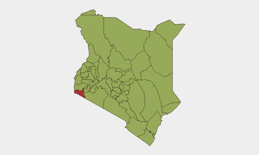
Kenya's composite threat score of 67 places it at #22 globally, with 296 tracked events reflecting a mix of criminal activity, border-region insurgency pressure, and periodic civic unrest. Migori County (77.2) stands as a significant outlier, driven by organized crime and cross-border trafficking; Nairobi and central highlands counties cluster in the 48–53 range, indicating localized but recurrent violence and lawlessness. The security picture remains volatile but not in acute crisis phase, with containment operations ongoing in high-risk zones.
Key Developments
- Mandera County (2026-07-25): Kenyan police reported disruption of a suspected al-Shabaab attack near the Somalia border; a student was shot during the incident and security operations remain active in the area.
- Migori County (recent, within past week): Directorate of Criminal Investigations officers recovered illegal firearms and suspected stolen property following a security operation; three arrests made. Reflects ongoing organized crime pressure in Kenya's highest-risk zone.
- Kisii County, Kisii–Keroka road (recent, within past week): Three suspects arrested following an attack on a convoy linked to political leaders; indicates targeted violence and political-security nexus.
- Nairobi / Gatundu North Sub-County (recent, within past week): A student at St Francis Girls High School Mang'u was shot and injured by stray fire during a public event, underscoring civilian exposure to chaotic incident environments.
- Marsabit County (recent): Interior Cabinet Secretary extended security-disturbed designations for 13 areas for an additional 30 days, signaling persistence of cross-border and pastoral conflict drivers.
- Samburu County (recent): County commissioners ordered to accelerate hiring of chiefs and sub-chiefs in newly established administrative locations to address insecurity gaps—indicates resource constraints in peripheral security operations.
Highest-Risk Areas
Migori County's risk score of 77.2—nearly 50% higher than the national average—reflects organized crime networks, cross-border trafficking flows, and weak state presence. Nairobi and the central highlands (Embu, Murang'a, Kiambu) cluster at 50–53 in risk, driven by urban gang activity, land disputes, and political volatility during electoral cycles. Northern pastoral and border regions (Isiolo, Turkana, Samburu) face recurring al-Shabaab and Al-Qaeda pressure, cattle rustling, and weak institutional reach. Together, these zones account for the majority of GeoBit's 296 tracked events and represent the primary duty-of-care exposure for corporate operations and personnel.
How GeoBit Would Assist
Security teams can deploy Intel Sweep and global event feeds to monitor Migori, Nairobi, and border counties in near-real time, supplemented by OSINT fusion (X, Telegram, and radio SIGINT) to track emerging actor statements, conflict signals, and insurgent activity. AOI Monitoring & Early Warning on Mandera, Marsabit, and Samburu—tied to persistent al-Shabaab and rustling networks—enables proactive alerting before incidents escalate. Routing & Network Analysis supports duty-of-care route planning for personnel and asset movement, avoiding high-incident corridors and real-time danger zones.
7-Day Outlook
No significant de-escalation is anticipated in the near term; border-region insurgency activity and organized crime in Migori are structural challenges unlikely to resolve within days. Nairobi and central regions may see periodic spikes tied to political activity or gang territorial disputes. Continued monitoring of Mandera and northern counties for al-Shabaab activity is essential given recent disruption claims and seasonal migration/conflict cycles.
Highest-Risk Areas — Ranked
| # | State / Region | Risk |
|---|---|---|
| 1 | Migori County | 77.2 |
| 2 | Nairobi County | 52.9 |
| 3 | Embu | 52.9 |
| 4 | Murang'a County | 50.1 |
| 5 | Isiolo | 48.9 |
| 6 | Kiambu | 48.9 |
| 7 | Bungoma County | 48.9 |
| 8 | Taita–Taveta | 48.3 |
| 9 | Turkana County | 48.3 |
| 10 | Homa Bay County | 47.8 |
| 11 | Nakuru | 47.8 |
| 12 | Busia County | 47.2 |
Sources
Previous Daily Briefs
A new Kenya brief is written every day — each with its own risk map and downloadable CSV. Here's the last week; use the calendar to go further back.
📅 Browse every day by calendar →
Highlighted days have a brief. Tap a day for that day's map & analysis, or “csv” for that day's dataset ($5).
Atlas — our AI intelligence desk — emails them this snapshot personally. Nothing else, no list.