Situation Summary
Lebanon remains under sustained military pressure following the collapse of a ceasefire framework on 19 June 2026. Despite a 16:00 local-time truce agreement, Israeli forces conducted at least 12 airstrikes and artillery bombardments in South Lebanon after the ceasefire took effect, killing at least 47 people and wounding 97 others in a single 24-hour period. The Beqaa Governorate carries the highest composite risk score (88.9), driven by ongoing militia activity and cross-border military operations, while South and Nabatieh governorates remain acutely volatile due to active Israeli strikes and mass internal displacement (131,200 persons in collective shelters as of mid-June). Diplomatic de-escalation efforts, including planned U.S.–Iran technical talks in Switzerland, have been canceled due to the intensity of hostilities.
Key Developments
- Israeli airstrikes post-ceasefire, South Lebanon (19 June, 16:00+): At least 12 airstrikes and artillery strikes on targets in South and Nabatieh governorates occurred after the announced ceasefire start time, killing ≥47 and wounding 97 according to Lebanese Health Ministry. Israel stated it was maintaining "operational freedom" against perceived Hezbollah threats.
- Overnight strike wave and casualty toll, southern and eastern Lebanon (18–19 June, midnight onward): Lebanese authorities documented 21+ killed in Israeli strikes on southern and eastern Lebanon in the hours immediately preceding the ceasefire renewal, with Hezbollah reporting "intense fighting."
- Fresh displacement orders issued, South and Nabatieh (12–14 June, effects ongoing): UN OCHA documented seven displacement orders covering 37 localities, compounding displacement that now totals 131,200 persons in 644 collective shelters; returns remain "limited and cautious."
- U.S.–Iran technical talks canceled (19 June): Planned diplomatic engagement in Switzerland was canceled due to escalated Israel–Hezbollah violence in southern Lebanon, indicating that ceasefire frameworks remain fragile and day-of security conditions too volatile for parallel negotiations.
- Daily child casualty rate continues (17 June statement, ongoing): UNICEF confirmed an average of 12 children killed or maimed daily over 100+ days of current conflict, with 770,000 children displaced nationwide and exposed to explosive remnants, indicating widespread and sustained risk beyond frontline zones.
- Militia vs. state military operations reported (20 June): Event signals indicate conventional military force clashes between militia and Lebanese Army units, signaling internal security fragmentation alongside external strikes.
Highest-Risk Areas
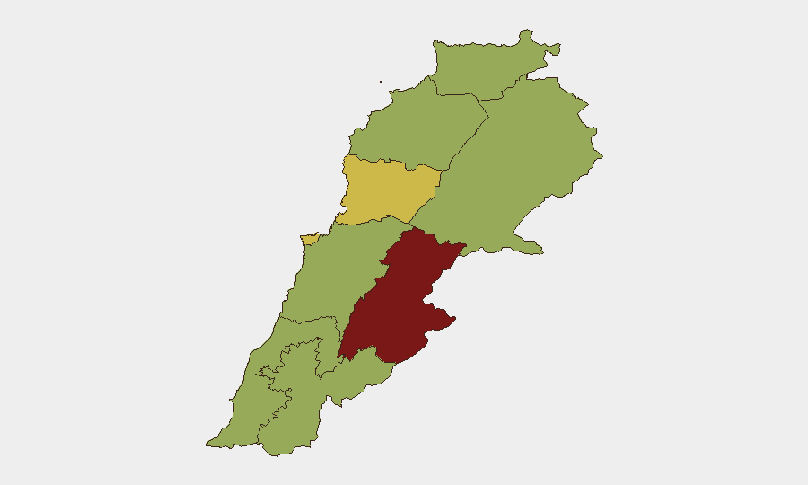
Beqaa Governorate (88.9 composite score) is the single highest-risk zone, driven by militia presence, unconventional violence, and cross-border military activity. South Governorate (59.1) and Nabatieh Governorate (59.8) follow closely, with acute risk from sustained Israeli airstrikes, active displacement, and insufficient humanitarian infrastructure. Beirut Governorate (69.5) ranks second overall despite lower street-level violence, reflecting infrastructure vulnerability, mass displacement effects, and political instability. North Governorate, Akkar, and Baalbek-Hermel (all 58.9) show convergent risk, indicating dispersed rather than isolated threat geography.
How GeoBit Would Assist
Security teams should employ AOI Monitoring & Early Warning on South, Nabatieh, and Beqaa governorates to detect strike patterns and displacement triggers in real time. Routing & Network Analysis and Intel Sweep (X/Telegram OSINT, multi-language feeds) would enable near-real-time confirmation of operational closure, ceasefire violations, and safe corridor availability. Satellite & Imagery analysis combined with Humanitarian & NGO data integration would track displacement site security, shelter capacity, and access route integrity for personnel and supply movements.
7-Day Outlook
Ceasefire frameworks remain unstable; Israeli operational statements claiming "freedom of action" and the 19 June strike wave suggest enforcement will be contested through at least 24–27 June. Internal displacement is likely to accelerate in South and Nabatieh if strikes resume, further degrading humanitarian access and increasing kidnap/hostage risk in congested shelter areas. Diplomatic channels (U.S.–Iran talks) are stalled, reducing near-term de-escalation probability; risk trajectory remains upward absent external intervention.
Highest-Risk Areas — Ranked
| # | State / Region | Risk |
|---|---|---|
| 1 | Beqaa Governorate | 88.9 |
| 2 | Beirut Governorate | 69.5 |
| 3 | Keserwan-Jbeil Governorate | 62.2 |
| 4 | Nabatieh Governorate | 59.8 |
| 5 | South Governorate | 59.1 |
| 6 | Mount Lebanon Governorate | 59 |
| 7 | North Governorate | 58.9 |
| 8 | Akkar Governorate | 58.9 |
| 9 | Baalbek-Hermel Governorate | 58.9 |
Sources
Previous Daily Briefs
A new Lebanon brief is written every day — each with its own risk map and downloadable CSV. Here's the last week; use the calendar to go further back.
📅 Browse every day by calendar →
Highlighted days have a brief. Tap a day for that day's map & analysis, or “csv” for that day's dataset ($5).