Situation Summary
Lesotho presents a low and stable security environment as of 29 July 2026, with no confirmed acute incidents, civil unrest, or infrastructure disruption in the past 24–48 hours. The country's composite threat score of 3 reflects routine urban crime risk concentrated in Maseru District (78) and secondary urban centres, alongside persistent transnational organised crime vulnerability—most recently underscored by methamphetamine manufacturing activity and cross-border financial crime. National security capacity is being strengthened through the inaugural launch of a cyber incident response capability, indicating institutional focus on emerging rather than immediate kinetic threats.
Key Developments
- Maseru, 29 July 2026 – Official launch of the Interim National Computer Security Incident Response Team (LesComCSIRT) and National Cybersecurity Forum at Avani Lesotho Hotel, presided over by the Minister of Information, Communications, Science, Technology and Innovation. This marks a formal institutional response to cyber risk and reflects government prioritisation of digital resilience.
- Maseru, 26 July 2026 – Medical emergency at Queen 'Mamohato Memorial Hospital involving a South African delegate attending the ESARBICA conference who became critically ill en route to Moshoeshoe I International Airport; pronounced dead on arrival. A second delegate collapsed on notification and was treated at Makoanyane Military Hospital and discharged. No criminal or civil unrest linkage identified; incident demonstrates routine medical emergency response capability.
- Regional monitoring (28–29 July 2026) – No confirmed civil unrest, roadblocks, protests, or major infrastructure disruptions reported in Lesotho. Operating environment remains stable with normal precautions warranted for urban travel and business.
- U.S. Embassy advisory (late July 2026) – Public warnings issued regarding Lesotho's vulnerability to transnational organised crime, citing recent record-breaking methamphetamine manufacturing busts as evidence of organised criminal network presence. No specific acute incident tied to advisory, but reflects ongoing concern about illicit drug production and cross-border criminal activity.
- Cross-border context (17–20 July 2026) – A 52-year-old Lesotho national arrested in Bojanala Platinum District, South Africa, in connection with ATM bombing investigations; recovered dye-stained banknotes suggest linkage to regional financial crime. Incident occurred outside Lesotho but illustrates cross-border criminal risk involving Lesotho nationals.
Highest-Risk Areas
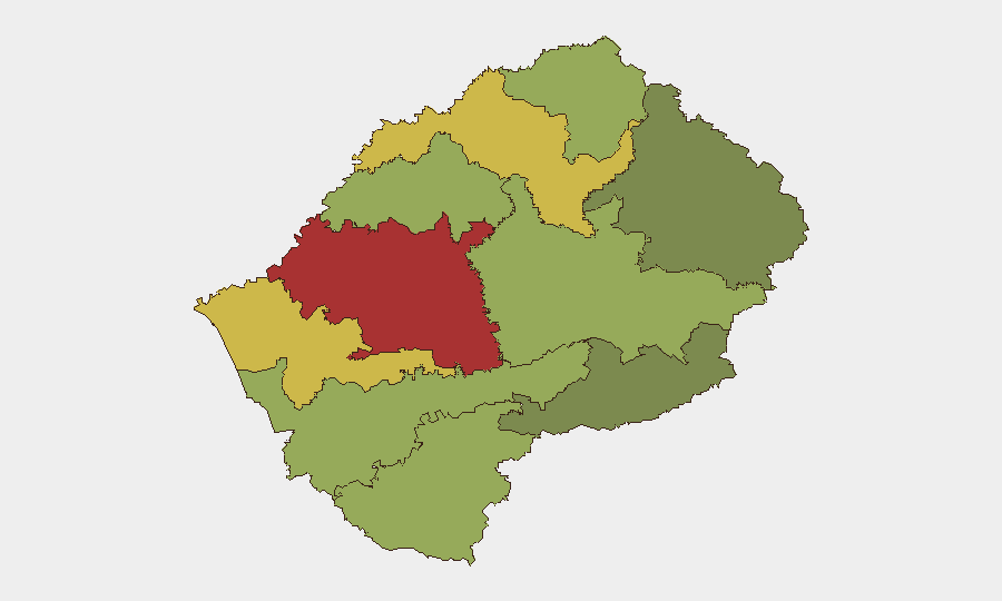
Maseru District (78) dominates national threat concentration, reflecting capital-city urbanisation, cash-economy vulnerability to organised crime, and density of cross-border transit. Secondary-tier risk in Mafeteng (65) and Leribe (62) districts indicates spread of urban crime and organised crime activity beyond the capital. Remote southern and eastern districts (Qacha's Nek, 28; Mokhotlong, 38) register significantly lower risk, suggesting that threat concentration remains urban-corridor dependent. Transnational crime vectors—particularly drug manufacturing and cash-in-transit activity—appear to correlate with border proximity and transport infrastructure.
How GeoBit Would Assist
Security teams with personnel or assets in Lesotho would employ Intel Sweep and OSINT fusion to track transnational organised crime networks and early indicators of criminal activity in high-risk districts; AOI Monitoring & Early Warning on Maseru and secondary urban centres to detect protest activity, roadblocks, or civil unrest; and Routing & Network Analysis to identify secure transit corridors and alternative routes in high-crime zones. Cross-border network and actor analysis would support ongoing cross-referenced intelligence on Lesotho nationals involved in regional financial crime.
7-Day Outlook
No acute escalation is anticipated over the next seven days; the stable baseline and absence of protest signals suggest continuity of routine crime risk. Organised crime activity will remain endemic but not acutely disruptive to business or travel. Security teams should maintain standard duty-of-care protocols for Maseru and monitor for any change in transnational criminal network activity signalled through regional channels.
Highest-Risk Areas — Ranked
| # | State / Region | Risk |
|---|---|---|
| 1 | Maseru District | 78 |
| 2 | Mafeteng District | 65 |
| 3 | Leribe District | 62 |
| 4 | Berea District | 58 |
| 5 | Mohale's Hoek District | 52 |
| 6 | Butha-Buthe District | 48 |
| 7 | Thaba-Tseka District | 45 |
| 8 | Quthing District | 42 |
| 9 | Mokhotlong District | 38 |
| 10 | Qacha's Nek District | 28 |
Sources
Previous Daily Briefs
A new Lesotho brief is written every day — each with its own risk map and downloadable CSV. Here's the last week; use the calendar to go further back.
📅 Browse every day by calendar →
Highlighted days have a brief. Tap a day for that day's map & analysis, or “csv” for that day's dataset ($5).
Atlas — our AI intelligence desk — emails them this snapshot personally. Nothing else, no list.