Situation Summary
Liberia presents a stable security environment as of 2 August 2026, with no corroborated incidents of violence, civil unrest, or acute conflict reported in the past 24–48 hours. Open-source monitoring across national media, police reports, and social platforms confirms quiet conditions nationwide. However, underlying structural risks—particularly in border counties and regions with limited state presence—remain elevated and warrant continued monitoring of personnel and asset locations.
Key Developments
No discrete security, crime, conflict, or civil-unrest incidents were corroborated in Liberia during 2–3 August 2026. Available reporting from national news outlets, police bulletins, and social media monitoring identified no fresh attacks, protests, armed clashes, robberies, or infrastructure failures in the 24–48 hour window.
Prior reporting (late July–early August) noted ongoing court proceedings and security-sector reform initiatives at the national level, but these do not constitute acute incidents affecting personnel safety or asset security in the current cycle.
Highest-Risk Areas
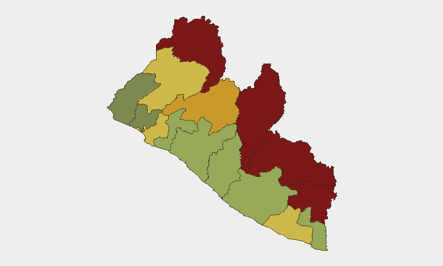
Nimba, Lofa, and Grand Gedeh counties (risk scores 92, 88, and 85 respectively) drive the country's elevated composite threat profile. These northeastern and eastern border regions face recurring challenges: limited state capacity, transnational trafficking (drugs and contraband), cross-border armed-group activity, and historical conflict legacies. Nimba County's score of 92 reflects persistent vulnerabilities in security-force presence and community stability. Organizations with operations or supply chains in these counties should apply enhanced due diligence, restricted movement protocols, and liaison with local authorities. Montserrado County (Monrovia, score 64) and Margibi County (Roberts International Airport, score 52) present moderate risk; urban crime and occasional civil tensions occur, but systematic violence is not currently reported.
How GeoBit Would Assist
Security teams monitoring Liberia should employ Area-of-Interest (AOI) Monitoring & Early Warning on Nimba, Lofa, and Grand Gedeh counties to detect emerging armed movement, protests, or trafficking activity before operational impact. Intel Sweep and multi-source OSINT fusion (news, social media, local radio SIGINT) provide real-time corroboration of rumors and unverified reports, reducing false alarms and enabling faster response to genuine threats. Routing & Network Analysis supports safe alternative journey planning for personnel transiting high-risk counties or border zones, while GIS & Spatial Analysis overlays personnel locations, asset caches, and current threat hotspots to inform duty-of-care decision-making.
7-Day Outlook
No acute escalation is forecast for the next seven days. Liberia's security environment is expected to remain stable in the short term, though endemic border-region vulnerabilities and transnational criminal activity will persist as baseline risks. Duty-of-care teams should maintain standard elevated protocols in Nimba, Lofa, and Grand Gedeh and continue passive monitoring of Monrovia for sporadic urban crime; no specific trigger for policy change is anticipated before 10 August 2026.
Highest-Risk Areas — Ranked
| # | State / Region | Risk |
|---|---|---|
| 1 | Nimba County | 92 |
| 2 | Lofa County | 88 |
| 3 | Grand Gedeh County | 85 |
| 4 | River Gee County | 83 |
| 5 | Bong County | 72 |
| 6 | Gbarpolu County | 68 |
| 7 | Grand Kru County | 65 |
| 8 | Montserrado County | 64 |
| 9 | Rivercess County | 58 |
| 10 | Sinoe County | 55 |
| 11 | Margibi County | 52 |
| 12 | Grand Bassa County | 48 |
Sources
- geobit.ai
- smartnewsliberia.com
- thenewsnewspaperonline.com
- thenewsnewspaperonline.com
- fpa.news
- micat.gov.lr
- knewsonline.com
- thenewdawnliberia.com
- liberianinvestigator.com
- instagram.com
- thenewsnewspaperonline.com
- smartnewsliberia.com
- thenewdawnliberia.com
- liberianinvestigator.com
- reuters.com
- lina.micat.gov.lr
- knewsonline.com
- facebook.com
Previous Daily Briefs
A new Liberia brief is written every day — each with its own risk map and downloadable CSV. Here's the last week; use the calendar to go further back.
📅 Browse every day by calendar →
Highlighted days have a brief. Tap a day for that day's map & analysis, or “csv” for that day's dataset ($5).
Atlas — our AI intelligence desk — emails them this snapshot personally. Nothing else, no list.