Situation Summary
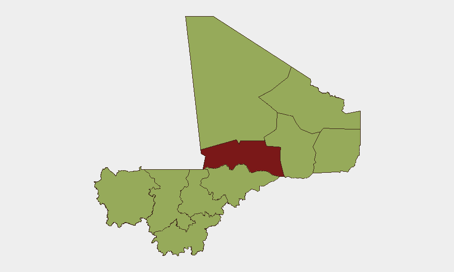
Mali remains Africa's highest-insurgency-burden state, with composite threat score 77 and 59 tracked security events. Counter-terrorism operations by authorities continue alongside persistent activity by extremist networks across the Sahel. The security environment has shown no material improvement; risk remains acute in northern and central regions, with Timbuktu presenting the sharpest immediate threat profile (risk score 84). Corporate and expatriate presence faces elevated exposure to kidnapping, armed robbery, and indirect fire in designated high-risk zones.
Key Developments
- Mali (countrywide) — 16 June 2026 — Malian authorities launched investigative operations targeting extremist actors, underscoring ongoing counter-terrorism activity. (Source: GeoBit intelligence feed)
- Mali (countrywide) — 16 June 2026 — Public diplomatic signal issued from Dakar directed at Mali's president; exact content not yet clarified, but signals potential regional political tension. (Source: GeoBit event signal)
- Mali (countrywide) — 14 June 2026 — Official public disapproval issued against Al Qaeda-affiliated organizations, reflecting hardening of government counter-extremism messaging. (Source: GeoBit intelligence)
Note: Web research conducted over the last 24 hours did not yield independently verifiable, geolocated discrete security incidents beyond the above three items. Broader trend data (kidnapping prevalence, militia activity, humanitarian displacement) remain consistent with historical patterns but lack current-window specificity. GeoBit's event feed is the primary source for near-real-time Mali developments at this time.
Highest-Risk Areas
Timbuktu region dominates the risk landscape (84/100), driven by persistent insurgent presence, repeated attacks on civilian and military targets, and limited state control. Bamako (57.8) presents secondary but significant risk, concentrated in political volatility and urban crime affecting business districts and expatriate enclaves. Nine additional regions (Ménaka, Kayes, Taoudénit, Kidal, Gao, Koulikoro, Ségou, Sikasso, Mopti) cluster at risk score 54, indicating widespread Sahel-zone instability. Northern tier dominance reflects jihadist group activity and inter-communal conflict; central-zone parity reflects spillover effects and banditry networks.
How GeoBit Would Assist
Teams with personnel or assets in Mali should deploy AOI Monitoring & Early Warning on Timbuktu, Bamako, and Ségou (highest-transit corridors) to receive real-time alerts on armed activity, checkpoints, and abduction risk. Intel Sweep and multi-language OSINT (X/Twitter, Telegram, local media) provide 24–48-hour event corroboration and actor-intent analysis; paired with Network & Actor Analysis, this clarifies which extremist cells are operationally active and where. Conflict & Military battle mapping and Routing & Network Analysis enable security teams to model safe transit corridors, alternate supply lines, and evacuation vectors in real time.
7-Day Outlook
Investigative and counter-terror tempo is expected to remain elevated, but insurgent capability shows no sign of degradation. Diplomatic friction between Mali and regional partners (Senegal signal) may complicate cross-border military coordination or humanitarian access. No major tactical shift anticipated in the next 7 days; risk profile will likely hold or incrementally worsen as dry-season operational conditions favor mobile insurgent groups.
Highest-Risk Areas — Ranked
| # | State / Region | Risk |
|---|---|---|
| 1 | Timbuktu | 84 |
| 2 | Bamako | 57.8 |
| 3 | Ménaka | 54 |
| 4 | Kayes | 54 |
| 5 | Taoudénit Region | 54 |
| 6 | Kidal | 54 |
| 7 | Gao | 54 |
| 8 | Koulikoro | 54 |
| 9 | Ségou Region | 54 |
| 10 | Sikasso Region | 54 |
| 11 | Mopti | 54 |
Sources
Previous Daily Briefs
A new Mali brief is written every day — each with its own risk map and downloadable CSV. Here's the last week; use the calendar to go further back.
📅 Browse every day by calendar →
Highlighted days have a brief. Tap a day for that day's map & analysis, or “csv” for that day's dataset ($5).