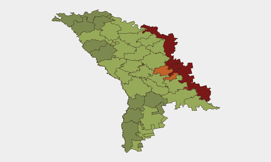
Situation Summary
Moldova remains a low-threat environment globally (rank #152, composite score 6), but faces acute localized risks concentrated in the Dniester Left Bank and border zones with Ukraine and Transnistria. On 17 August 2026, an unidentified aerial object—likely a Russian loitering munition that strayed during strikes on Ukraine's Odesa region—crossed Moldovan airspace, crashed near Talmaza in Ștefan Vodă district, and detonated, triggering a vegetation fire and brief airspace closure. The incident underscores Moldova's vulnerability to cross-border drone/munition spillover and has prompted sovereign-airspace enforcement by Moldovan defense and diplomatic channels.
Key Developments
- Talmaza, Ștefan Vodă district – 17 Aug 2026, ~17:37 local time
Moldovan airspace surveillance detected an unidentified aerial object entering from the Cuciurgan–Tiraspol axis; the device disappeared from radar near Talmaza in the southeast and subsequently exploded approximately 3 km outside the town, igniting dry vegetation and brush. No casualties reported; police and emergency services cordoned and extinguished the fire.
- Airspace closure response – Ștefan Vodă district – 17 Aug 2026
Moldovan authorities temporarily restricted airspace over the Centru region for approximately 15 minutes as a precautionary measure while the aerial object was tracked; normal operations resumed once the device was lost to radar.
- Preliminary attribution – Ștefan Vodă district – 17 Aug 2026
Ukrainian Air Force and regional outlets identified the object as a Russian "Banderol" loitering munition that deviated during a Russian strike on Ukraine's Odesa region. Moldovan authorities have not yet formally confirmed the device's origin, pending technical and explosives examination of wreckage.
- Diplomatic statement – 17–18 Aug 2026
Moldova's Foreign Ministry condemned the airspace violation and explosion as a "serious violation" of sovereignty and a direct risk to public safety, emphasizing coordinated investigation and response by defense, police, and emergency services.
- Technical investigation – Talmaza, Ștefan Vodă district – 17–18 Aug 2026
Police explosives specialists deployed to the impact site to identify the device type, assess residual explosive hazards, and secure the area pending final classification of the aerial object.
Highest-Risk Areas
The Dniester Left Bank (risk 85) and adjacent border districts—Dubăsari (82), Bender (79), Criuleni (75), Rezina (58)—dominate Moldova's sub-national threat profile, driven by Transnistria's unresolved status, Russian military presence, and proximity to active conflict in Ukraine. The 17 August incident near Talmaza in Ștefan Vodă (rank 51) demonstrates that border zones well south of Transnistria remain vulnerable to drone/munition overspill from cross-border operations; civilians and critical infrastructure in the southeast face periodic risk from errant or deliberately directed aerial threats. Chișinău (rank 49) remains a secondary concern, chiefly due to its size and symbolic significance in Moldova's political-security landscape.
How GeoBit Would Assist
Security teams monitoring Moldova should deploy AOI (Area-of-Interest) Monitoring & Early Warning with persistent watch over Ștefan Vodă, Dubăsari, and the Dniester Left Bank to detect drone/munition incursions and airspace violations in near-real time. Aviation tracking, satellite imagery analysis, and conflict intelligence feeds (via Intel Sweep and global event fusion) provide continuous visibility into cross-border aerial activity, Russian strike patterns on Ukraine, and deviation vectors. Routing & Network Analysis and GIS spatial tools enable rapid identification of safe corridors and alternative transit routes for personnel and assets in high-risk border zones.
7-Day Outlook
No imminent escalation is forecast, but the frequency of drone/munition overspill into Moldova is likely to persist as long as Russian air operations target Ukraine's Odesa and southern regions. Security posture in Ștefan Vodă and adjacent border districts should remain elevated; airspace compliance and emergency-response coordination will dominate official policy through at least late August.
Highest-Risk Areas — Ranked
| # | State / Region | Risk |
|---|---|---|
| 1 | Administrative-Territorial Units of the Left Bank of the Dniester | 85 |
| 2 | Dubăsari | 82 |
| 3 | Bender | 79 |
| 4 | Criuleni | 75 |
| 5 | Rezina | 58 |
| 6 | Taraclia | 55 |
| 7 | Gagauzia | 54 |
| 8 | Căușeni | 53 |
| 9 | Soroca | 52 |
| 10 | Ștefan Vodă | 51 |
| 11 | Orhei | 50 |
| 12 | Chișinău | 49 |
Sources
Previous Daily Briefs
A new Moldova brief is written every day — each with its own risk map and downloadable CSV. Here's the last week; use the calendar to go further back.
- August 15, 2026
- August 13, 2026
- August 11, 2026
- August 9, 2026
- August 7, 2026
- August 5, 2026
- August 4, 2026
📅 Browse every day by calendar →
Highlighted days have a brief. Tap a day for that day's map & analysis, or “csv” for that day's dataset ($5).
Atlas — our AI intelligence desk — emails them this snapshot personally. Nothing else, no list.