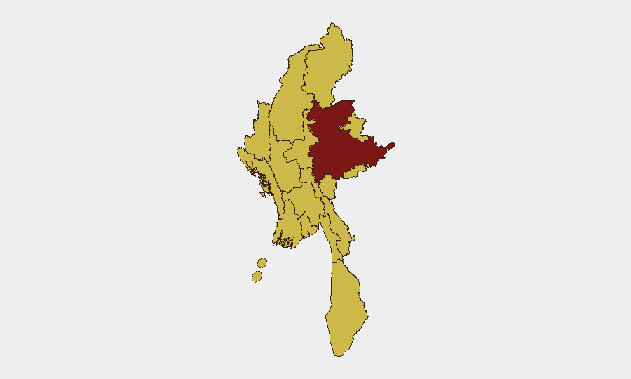
Situation Summary
Myanmar remains engulfed in active civil conflict, ranking #10 globally in composite threat. Recent diplomatic tensions with China and US law-enforcement actions signal widening international dimensions to the crisis, while the conflict continues to fragment state control across multiple regions. The 6 tracked events over the reporting period indicate sustained multi-actor instability rather than de-escalation. Civil war remains the primary driver of risk across nearly all sub-national territories.
Key Developments
- 2026-06-16 · US Arrest/Detain Action: US authorities detained a Myanmar national or entity; specific charges and location not yet clarified in available reporting. Assess for potential diplomatic escalation or sanctions cascade.
- 2026-06-17 · Myanmar Threatens China: Myanmar government issued public threat statement directed at China, following earlier appeals from Xi Jinping (2026-06-17). Indicates deterioration in state-to-state relations during active civil conflict.
- 2026-06-17 · Multiple Myanmar–China Public Statements: Two additional public statements from Myanmar toward China on same date. Pattern suggests rapid diplomatic escalation or crisis communication cycle.
- 2026-06-16 · Administrative Sanctions: Myanmar authorities issued domestic sanctions; target(s) and scope unclear from signal metadata.
- 2026-06-16 · Myanmar–Mexico Administrative Sanctions: Bilateral administrative action; context and impact not specified in current data.
- Recent Seismic Event: M 4.4 earthquake, 82 km ENE of Loikaw (Shan State), may have caused localized infrastructure or displacement impacts in already-fragile region.
- Flood Event: Active flooding reported in Myanmar; geographic specificity and casualty data not available; likely to compound humanitarian access and internal displacement pressures.
*Note: Specificity of incident detail is limited by data availability. Operational teams with on-ground sources or access to live reporting should cross-check and supplement these signals with real-time local intelligence.*
Highest-Risk Areas
Shan State ranks highest (risk 100) and remains the dominant threat driver due to active armed-group presence, border permeability, and fragmented government control. Nine additional regions—including Tanintharyi, Chin, Sagaing, Kachin, Mandalay, Yangon, and the capital Naypyitaw—all score 70 or above, indicating systemic national risk rather than regional concentration. The breadth of high-risk zones reflects civil-war fragmentation. Yangon and Naypyitaw, despite being administrative centers, remain elevated due to protest activity, security-force actions, and potential for sudden political/security shifts.
How GeoBit Would Assist
AOI Monitoring & Early Warning with persistent watch on Shan State, Yangon, and Mandalay would provide alert-triggered notification of armed clashes, checkpoints, or movement restrictions affecting staff/asset routes. Routing & Network Analysis can generate real-time alternative journey plans bypassing conflict zones and recent flood impact, with estimated security posture by corridor. OSINT Fusion (X/Twitter, Telegram, local news, and radio SIGINT) combined with Network & Actor Analysis would clarify the current positions and intentions of armed groups, militia, and junta forces, improving duty-of-care decision-making for evacuation, shelter-in-place, or restricted-movement protocols. Satellite & Imagery Analysis can confirm infrastructure status (bridges, airports, checkpoints) critical to contingency planning.
7-Day Outlook
US–Myanmar and China–Myanmar tensions are unlikely to resolve within 7 days; watch for secondary impacts on visa processing, customs clearance, or security-force conduct toward foreign nationals. The M 4.4 earthquake and ongoing floods may degrade road and air routes in Shan and surrounding regions for 3–5 days. Civil conflict trajectory remains unchanged; no major ceasefire or military shift is anticipated in the immediate outlook.
Highest-Risk Areas — Ranked
| # | State / Region | Risk |
|---|---|---|
| 1 | Shan State | 100 |
| 2 | Tanintharyi Region | 70 |
| 3 | Chin | 70 |
| 4 | Sagaing Region | 70 |
| 5 | Kachin State | 70 |
| 6 | Wa State (Northern Region) | 70 |
| 7 | Magway | 70 |
| 8 | Mandalay | 70 |
| 9 | Rakhine | 70 |
| 10 | Ayeyarwady | 70 |
| 11 | Yangon | 70 |
| 12 | Naypyitaw Union Territory | 70 |
Sources
Previous Daily Briefs
A new Myanmar brief is written every day — each with its own risk map and downloadable CSV. Here's the last week; use the calendar to go further back.
📅 Browse every day by calendar →
Highlighted days have a brief. Tap a day for that day's map & analysis, or “csv” for that day's dataset ($5).