Situation Summary
Nigeria maintains the second-highest global composite threat score (100/100), driven by persistent insurgency, armed group activity, and communal violence across multiple subnational zones. Over the past 24–48 hours, security incidents have been reported in Plateau, Kaduna, and Imo states, reflecting continued pressure in the country's northwest and northcentral regions. The threat environment remains volatile, with recent diplomatic friction (UK disapproval signal on 2026-06-20) and cross-border military activity in Niger adding complexity to the operating landscape. Overall trajectory indicates sustained rather than escalating risk, but localized flashpoints require active monitoring.
Key Developments
- Kuru, Plateau State (2026-06-22, today): The National Institute for Policy and Strategic Studies (NIPSS) confirmed a security incident near its campus. Security agencies responded and brought the situation under control; a formal investigation has been launched. Context: Plateau State ranks 12th nationally by composite risk but remains volatile.
- Rigasa, Igabi LGA, Kaduna State (2026-06-22, today): Kaduna State government announced a 34 billion naira erosion-remediation project and relocation of displaced residents due to severe gully erosion. While infrastructural rather than security-driven, this displacement activity may create secondary movement and vulnerability in an already high-risk zone (Kaduna ranks #1 nationally).
- Cross-border military activity, Niger (2026-06-20): Conventional military force activity and a terrorist group engagement were reported in Niger. Given Nigeria's shared northern border, such activity can spill across or disrupt regional supply/movement corridors.
- Farmer-related public statement (2026-06-22): A public statement attributed to farmers on 2026-06-22 suggests possible agrarian grievance or land-use tension; specific location and details remain unclear from available signals.
- Armed group small-arms combat (2026-06-21): Small-arms engagement involving an armed group was recorded on 2026-06-21. Geographic specificity is not yet confirmed in available reporting.
- Political and ministerial disapproval signals (2026-06-20 to 2026-06-22): UK disapproval of Nigerian actors, ministerial disapproval, and presidential disapproval of a politician suggest diplomatic and internal governance friction; these do not directly indicate tactical threats but may signal policy shifts affecting security operations or sanctions regimes.
*Note: Web research for the past 24–48 hours yielded limited independently verified, precisely dated tactical incidents beyond those listed above. GeoBit's X/Twitter, Telegram, and multi-language OSINT feeds may contain additional real-time signals not captured in this summary.*
Highest-Risk Areas
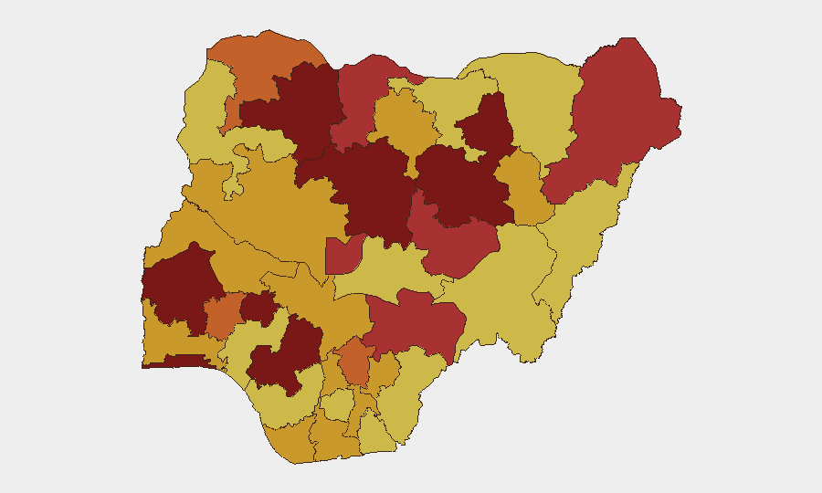
Kaduna State (risk 100) and Lagos State (risk 96.5) drive Nigeria's composite threat score. Kaduna faces sustained insurgent and armed-group pressure in rural and peri-urban zones, compounded today by large-scale displacement from erosion. Lagos, despite its urban development and stronger state capacity, remains vulnerable to kidnapping, armed robbery, and trafficking networks due to population density and maritime/border exposure. Oyo, Zamfara, Edo, and Bauchi states round out the top tier, each presenting distinct drivers: communal conflict, banditry, and criminal enterprise. The northcentral cluster (Plateau, Benue, Katsina) reflects spillover from Borno/northeast insurgency and cross-border bandit networks.
How GeoBit Would Assist
Corporate security teams should deploy AOI Monitoring & Early Warning on Kaduna, Lagos, and Plateau states to receive real-time alerting on armed activity, displacement events, and checkpoint changes. Intel Sweep, X/Twitter OSINT, and multi-language search capabilities would track farmer grievances, political fracture signals, and cross-border military activity that precede tactical incidents. Routing & Network Analysis would enable secure journey planning and identification of alternative supply routes around active conflict zones, while Satellite & Imagery analysis would monitor displacement camps and erosion-affected areas in real time.
7-Day Outlook
Short-term risk is expected to remain elevated but steady. Kaduna's erosion-driven displacement may create temporary security gaps and increase banditry targeting vulnerable populations. Cross-border spillover from Niger and continued armed-group activity in the northwest and northcentral regions should be monitored for escalation, particularly around supply corridors and state borders. No significant policy change or military offensive is signaled for the next 7 days, but communal and agrarian tensions may generate localized flare-ups.
Highest-Risk Areas — Ranked
| # | State / Region | Risk |
|---|---|---|
| 1 | Kaduna State | 100 |
| 2 | Lagos State | 96.5 |
| 3 | Oyo State | 93.5 |
| 4 | Zamfara State | 83.5 |
| 5 | Edo State | 83 |
| 6 | Bauchi State | 81.9 |
| 7 | Ekiti State | 81.1 |
| 8 | Federal Capital Territory | 78.8 |
| 9 | Borno State | 78.2 |
| 10 | Benue State | 77.9 |
| 11 | Katsina State | 76.6 |
| 12 | Plateau State | 76 |
Sources
Previous Daily Briefs
A new Nigeria brief is written every day — each with its own risk map and downloadable CSV. Here's the last week; use the calendar to go further back.
📅 Browse every day by calendar →
Highlighted days have a brief. Tap a day for that day's map & analysis, or “csv” for that day's dataset ($5).