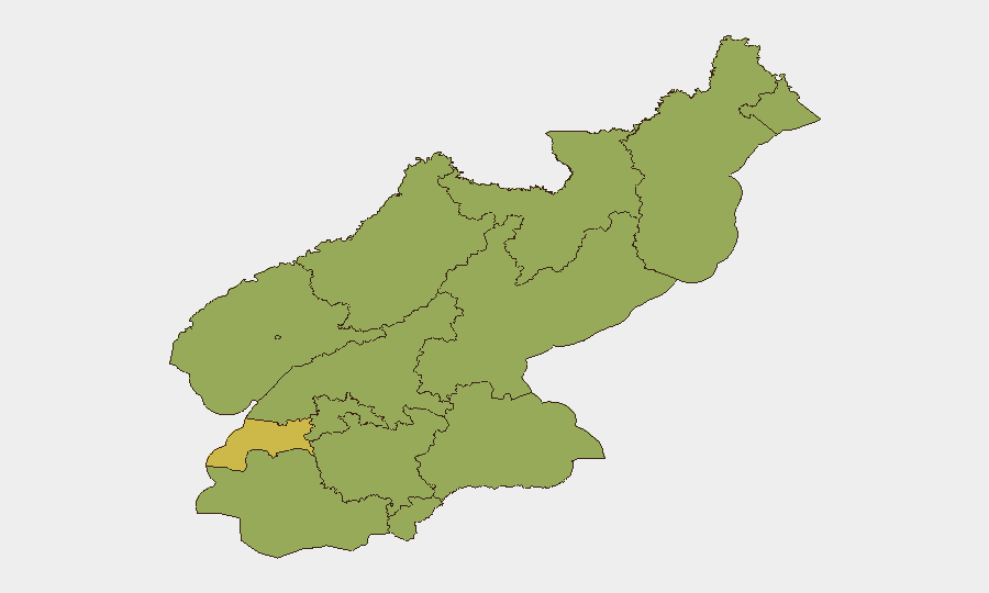
Situation Summary
North Korea remains at composite threat level #38 globally (score 57) with no confirmed new kinetic, civil-unrest, or infrastructure incidents documented in the last 24–48 hours by major wire agencies or multi-source open-source monitoring. Current reporting consists primarily of diplomatic and strategic analysis (G7 discussions, nuclear policy commentary, sanctions) rather than discrete on-the-ground security events. Baseline risks—political detention, information control, chronic military posturing, and cyber threat activity—remain structurally elevated, but there is no evidence of acute escalation or fresh provocation inside DPRK territory as of 20 June 2026.
Key Developments
- No confirmed new incidents inside North Korea in the last 24–48 hours. Wire agencies (Reuters, AP, AFP, Yonhap, NK News) have published no reports of missile tests, nuclear activity, cross-border clashes, internal unrest, or infrastructure disruptions in North Korea between 18–20 June 2026. Open-source signals are policy-focused, not incident-driven.
- South Korean Civilian Control Line adjustment (DMZ region, 17 June). Seoul announced a planned policy change to the Civilian Control Line near the demilitarized zone; this reflects ongoing operational posture, not a response to a new North Korean provocation. No cross-border shooting, infiltration, or mine incidents have been reported by ROK MND or UN Command in the subsequent 48-hour window.
- Diplomatic positioning on nuclear talks (nationwide policy level, 19 June). South Korean President Lee Jae-myung characterized U.S. President Trump's openness to a phased nuclear agreement with North Korea following G7 discussions. This is a strategic-communication statement, not an operational security event.
- No geolocated social-media evidence of protests or civil unrest. X/Twitter and open platforms show no corroborated new footage of demonstrations, riots, or visible public discontent in Pyongyang, provincial capitals, or border towns in the last 48 hours. Existing posts referencing "instability" lack multi-source confirmation or current satellite-imagery support.
- No new cyber incidents attributed to North Korean actors in last 24–48 hours. Current cyber-headline recycling refers to 2025 crypto-theft estimates and ongoing campaign analyses, not fresh operations with documented 18–20 June attribution.
- Travel advisory and infrastructure risk posture unchanged. U.S. State Department, UK FCDO, and ROK MOFA maintain long-standing "do not travel" advisories for DPRK; no incident-driven updates to guidance have occurred in this period.
Highest-Risk Areas
Nampo (risk 70) and Pyongyang (58.3) remain the primary concentration points, reflecting port/economic-infrastructure sensitivity and regime-control intensity respectively. South Pyongan (45.4) and North Hamgyong (42.2) follow, driven by proximity to Chinese border, resource extraction, and historical labor-camp presence. All other provinces cluster at 40–45, indicating baseline elevated but relatively uniform risk distribution outside the top urban centers. Risk elevation in these zones reflects structural political-control mechanisms, detention infrastructure, and economic-monitoring intensity rather than acute new instability.
How GeoBit Would Assist
A security team protecting personnel or assets in North Korea would employ AOI (Area-of-Interest) Monitoring & Early Warning on Nampo port, Pyongyang transit nodes, and provincial capitals to detect signaling of new restrictions or unrest. Intel Sweep (global feeds, multi-language OSINT, entity extraction) combined with SIGINT monitoring of radio and official DPRK channels would provide early detection of policy or military posture shifts. Satellite & Imagery analysis and GIS mapping of checkpoint activity and force disposition around the DMZ would track whether diplomatic moves translate into operational changes on the ground.
7-Day Outlook
No near-term escalatory triggers are visible in open reporting. Diplomatic discussions on nuclear negotiations are likely to continue, and routine border-security adjustments may follow, but the absence of new incidents or public unrest signals suggests stability in the immediate term. Persistent monitoring of Nampo and Pyongyang for regime-driven policy announcements, travel restrictions, or foreign-national advisories remains the priority for duty-of-care teams.
Highest-Risk Areas — Ranked
| # | State / Region | Risk |
|---|---|---|
| 1 | Nampo | 70 |
| 2 | P'yŏngyang | 58.3 |
| 3 | South Pyongan | 45.4 |
| 4 | North Hamgyong | 42.2 |
| 5 | Ryanggang | 40 |
| 6 | North Pyongan | 40 |
| 7 | Chagang | 40 |
| 8 | South Hwanghae | 40 |
| 9 | North Hwanghae | 40 |
| 10 | South Hamgyong | 40 |
| 11 | Kaesong | 40 |
| 12 | Kangwon | 40 |
Sources
Previous Daily Briefs
A new North Korea brief is written every day — each with its own risk map and downloadable CSV. Here's the last week; use the calendar to go further back.
📅 Browse every day by calendar →
Highlighted days have a brief. Tap a day for that day's map & analysis, or “csv” for that day's dataset ($5).