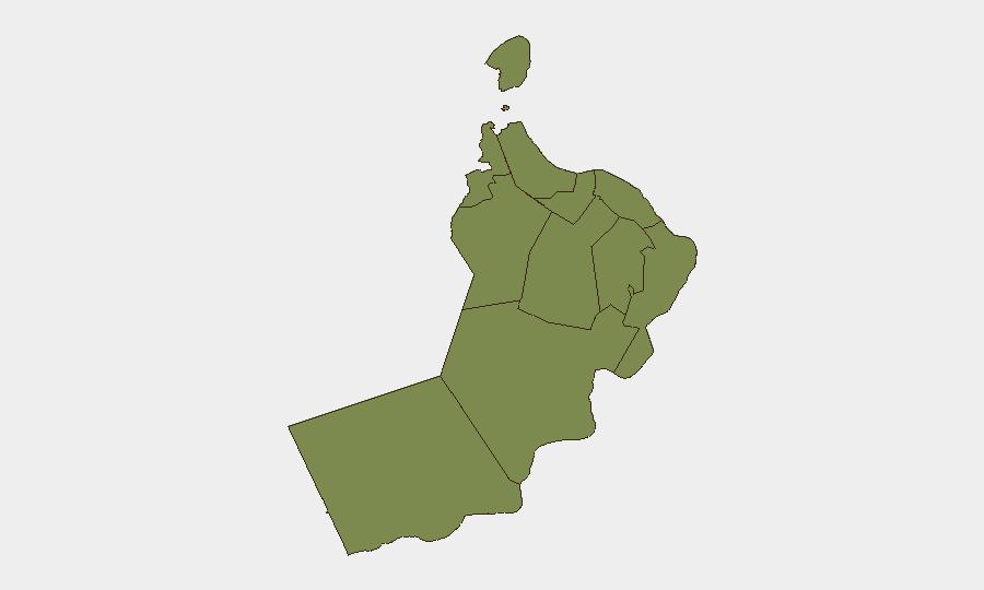
Situation Summary
Oman faces elevated maritime and regional geopolitical risk following a series of attacks on commercial shipping near the Strait of Hormuz over 48–72 hours, with a Qatari LNG tanker struck by projectile fire off Oman's coast on July 7 and multiple vessels targeted around the same period. Diplomatic activity centered in Muscat—including Iran–U.S. talks on de-escalation—underscores Oman's role as a conflict-mitigation hub, but also indicates underlying tension in the Persian Gulf and Gulf of Oman approaches. The overall threat level remains moderate (global rank #169), but maritime corridors and Muscat itself warrant heightened situational awareness.
Key Developments
- July 7, off Oman's coast (Strait of Hormuz approaches): Qatari LNG tanker *Al Rekayyat* struck by projectile, igniting engine-room fire; crew evacuated, cargo tanks intact; vessel remains stranded pending salvage. At least four additional tankers diverted from Hormuz in response.[4][10]
- July 8, Strait of Hormuz / Gulf of Oman: Two additional commercial vessels attacked or damaged near Hormuz; incident corroborated across Reuters and regional outlets alongside U.S. military response operations.[3][4]
- July 9–11, Muscat: Iran's foreign minister held phone calls with Oman's foreign minister (Sayyid Badr bin Hamad Al Busaidi) to coordinate on Strait security and de-escalation; Iran–U.S. talks on maritime and conflict issues resumed or are ongoing in Oman.[1][5]
- Recent (date unconfirmed), Muscat: Local reporting describes a shooting incident near a mosque in Muscat resulting in four Pakistani nationals killed; Omani authorities released statement condemning "terrorist plots." *Verification and precise timeline pending.*[6]
- July 7, northern Arabian Sea: UKMTO/JMIC advisory (Update 068) reports no new confirmed maritime incidents in the last 48 hours in the northern Arabian Sea east/southeast of Oman, indicating routine naval patrols and commercial traffic resumption outside the immediate Hormuz attack zone.[9]
Highest-Risk Areas
Al Wusta Governorate dominates the sub-national risk profile (31.5), reflecting its remote location and historical association with maritime and cross-border activity; however, the current spike is concentrated in maritime approaches and Muscat Governorate (6.4), where diplomatic activity and potential security incidents are most directly observable. The remaining governorates (Al Buraymi, Musandam, Ad Dhahirah, and others) register minimal differential risk (1.5 each), indicating that geopolitical and maritime threats are not evenly distributed across Oman. Corporate and duty-of-care teams should prioritize Muscat and seaport/maritime corridors.
How GeoBit Would Assist
Teams should deploy AOI Monitoring & Early Warning on Muscat and maritime chokepoints to track ongoing diplomatic activity and shipping incidents in near–real time. Maritime & Aviation tracking combined with OSINT fusion (X/Twitter, Telegram, news feeds) enables rapid corroboration of tanker movements, projectile attacks, and threat actor statements before they reach mainstream reporting. Routing & Network Analysis can model alternative supply-chain and personnel-movement corridors if Hormuz transit risk rises further.
7-Day Outlook
Diplomatic engagement in Muscat may stabilize the immediate situation, but maritime risk in the Strait of Hormuz and approaches to Oman is likely to remain elevated for the next 48–168 hours pending de-escalation outcomes. Commercial shipping patterns and port operations should be monitored continuously; any breakdown in Iran–U.S. talks or new attack could rapidly degrade security in Omani waters and reinforce diversion of traffic away from the region.
Highest-Risk Areas — Ranked
| # | State / Region | Risk |
|---|---|---|
| 1 | Al Wusta Governorate | 31.5 |
| 2 | Muscat Governorate | 6.4 |
| 3 | Musandam Governorate | 1.8 |
| 4 | Al Buraymi Governorate | 1.5 |
| 5 | Ad Dhahirah Governorate | 1.5 |
| 6 | Al Batinah North Governorate | 1.5 |
| 7 | Al Batinah South Governorate | 1.5 |
| 8 | Ad Dakhiliyah Governorate | 1.5 |
| 9 | Ash Sharqiyah North Governorate | 1.5 |
| 10 | Ash Sharqiyah South Governorate | 1.5 |
| 11 | Dhofar Governorate | 1.5 |
Sources
Previous Daily Briefs
A new Oman brief is written every day — each with its own risk map and downloadable CSV. Here's the last week; use the calendar to go further back.
📅 Browse every day by calendar →
Highlighted days have a brief. Tap a day for that day's map & analysis, or “csv” for that day's dataset ($5).
Atlas — our AI intelligence desk — emails them this snapshot personally. Nothing else, no list.