Situation Summary
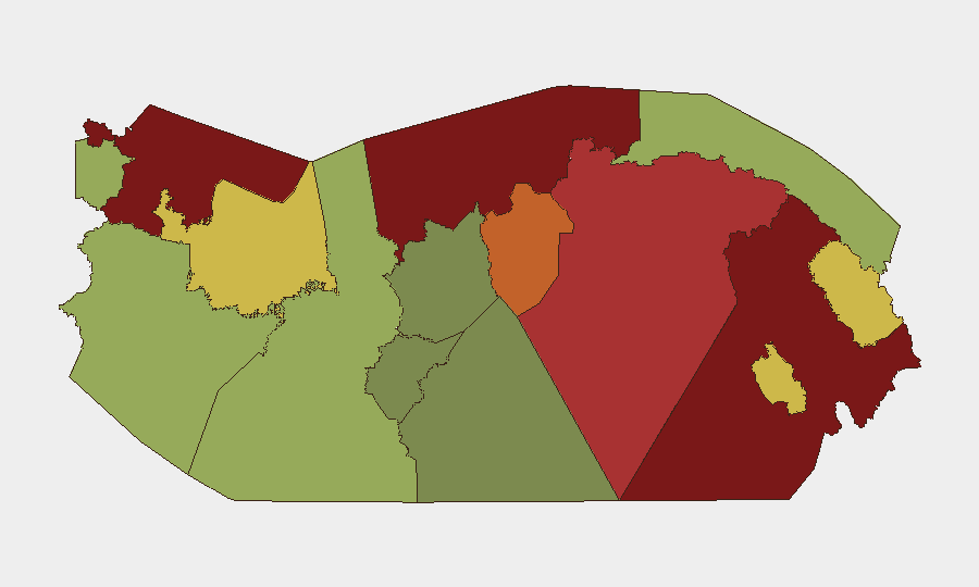
Panama's composite threat score of 28 places it in the lower-risk band globally, but sub-national variation is extreme: Darién (95), Colón (88), and Bocas del Toro (82) present acute security challenges, while central provinces remain moderate-risk. Over the last 48 hours, armed violence in Panama City (Panamá Viejo shootout, 28 July), coordinated police enforcement operations (193–574 arrests in 24–72-hour cycles), and ongoing transnational drug interdiction suggest heightened operational tempo rather than destabilization. Road safety remains a persistent secondary risk, with 289 traffic accidents and 87 injuries recorded in a 72-hour window across three provinces.
Key Developments
- Panama City, Panamá Viejo (28 July, morning) – Armed clash between occupants of two vehicles on Vía Cincuentenario near Calle Quinta left one fatality; security forces conducted large-scale follow-on cordon and search operations.
- Panama City, Campo Lindbergh (28 July) – Police located a second bullet-damaged vehicle provisionally linked to the Panamá Viejo incident; formal nexus not yet confirmed by authorities, but indicates potential follow-on violence or criminal retaliation.
- Nationwide, Plan Firmeza operations (27–28 July, 24-hour cycle) – National Police arrested 193 people (120 by warrant, 69 administrative, 7 micro-trafficking), conducted 33 raids, and seized 12 firearms, ammunition, and approximately US$15,400 in cash.
- Parallel nationwide enforcement (27–28 July, 24-hour cycle) – Separate police reporting indicates 132 arrests (91 ex officio, 33 administrative), 7 firearms seized, and 61 traffic accidents with 6 injuries, suggesting either dual reporting streams or overlapping operations.
- Three-province aggregate (Panama, Chiriquí, Coclé; 26–28 July, 72-hour window) – 574 arrests nationwide, 23 firearms seized, 289 traffic accidents, 87 injuries, and 3 fatalities, underscoring diffuse crime and accident risk across regions.
- Western Caribbean, offshore (late July, reported within 48h) – Joint Interagency Task Force South with Colombian Navy and Panama's National Aeronaval Service interdicted a go-fast vessel carrying approximately 587 kg of cocaine; two smugglers (Panamanian and Colombian national) detained, confirming active transnational trafficking.
- Seismic and flood events (recent) – M 4.3 earthquake recorded 203 km SSE of Burica; flooding reported in Panama; both pose secondary infrastructure and mobility risks.
Highest-Risk Areas
Darién (95) and Colón (88) dominate the risk profile, driven by historical narcotrafficking routes, porous borders, and limited state capacity. Bocas del Toro (82) and Panamá Province (78) reflect urban gang activity and spillover from maritime smuggling. Panama City itself, while not separately ranked, demonstrates localized armed-violence risk (two-vehicle shootout, 28 July). Central provinces (Coclé, Chiriquí, Naso Tjër Di) remain moderate-risk; Guna Yala and indigenous territories present lower but persistent criminal and logistical vulnerabilities.
How GeoBit Would Assist
Persistent AOI Monitoring & Early Warning would track high-risk provinces (Darién, Colón) and Panama City districts for emerging violence clusters or trafficking logistics. Network & Actor Analysis combined with OSINT (X/Telegram) would correlate the Panamá Viejo and Campo Lindbergh incidents in real time, confirming criminal-organization involvement and predicting retaliation. Maritime & Aviation Tracking would extend cocaine-interdiction visibility beyond single events, identifying trafficking corridors and vessel patterns. Routing & Network Analysis would provide security teams alternative travel corridors during high-violence windows.
7-Day Outlook
Plan Firmeza operations are likely to continue at current or elevated intensity, suppressing but not eliminating localized gang and trafficking activity. The Panamá Viejo shootout and linked vehicle discovery suggest possible intra-criminal disputes or enforcement actions; secondary violence or arrests are probable. Road-safety and maritime-trafficking risks remain persistent; weather (flood risk) may disrupt inland and border mobility over the next week.
Highest-Risk Areas — Ranked
| # | State / Region | Risk |
|---|---|---|
| 1 | Darién | 95 |
| 2 | Colón | 88 |
| 3 | Bocas del Toro | 82 |
| 4 | Panamá Province | 78 |
| 5 | Panamá Oeste | 75 |
| 6 | Ngäbe-Buglé | 68 |
| 7 | Emberá-Wounaan | 62 |
| 8 | Veraguas | 58 |
| 9 | Chiriquí | 48 |
| 10 | Naso Tjër Di | 45 |
| 11 | Guna Yala | 42 |
| 12 | Coclé | 35 |
Sources
Previous Daily Briefs
A new Panama brief is written every day — each with its own risk map and downloadable CSV. Here's the last week; use the calendar to go further back.
📅 Browse every day by calendar →
Highlighted days have a brief. Tap a day for that day's map & analysis, or “csv” for that day's dataset ($5).
Atlas — our AI intelligence desk — emails them this snapshot personally. Nothing else, no list.