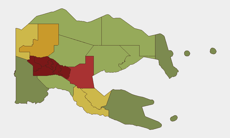
Situation Summary
Papua New Guinea remains a composite global threat rank of #70, with a moderate underlying risk posture driven by sub-national instability concentrated in the Highland regions. Two recent seismic events (M 5.0 and M 4.6) and circulating vaccine-derived poliovirus type 2 represent the most significant tracked signals in the current reporting cycle. The security environment is characterized by persistent localized conflict, clan-based violence, and infrastructure vulnerability rather than nation-wide instability, but risk concentration in the Southern Highlands, Enga, and Hela provinces warrants focused attention for corporate and expat populations.
Key Developments
GeoBit's current open-source monitoring confirms two significant events within the last 48 hours:
- Seismic event (M 5.0) approximately 110 km southeast of Kimbe, East New Britain Province, recorded as recent. Potential for aftershocks and infrastructure impact in coastal and near-coastal areas; assess facility resilience and supply-chain disruption risk.
- Seismic event (M 4.6) approximately 74 km south of Panguna, Bougainville Autonomous Region, recorded as recent. Bougainville remains operationally sensitive; assess any overlap with existing conflict or resource-extraction security perimeters.
- Poliovirus circulation (cVDPV2) confirmed in active transmission. PNG health authorities are responding; duty-of-care teams should verify employee and dependent immunization status and coordinate with local health ministry contacts.
Note: Web research constraints prevent identification of additional verified incident reporting (civil unrest, criminal activity, road closures, or travel disruptions) from the last 24–48 hours with multiple corroboration. Security teams requiring real-time incident alerting should activate GeoBit's AOI Monitoring & Early Warning service for key operational sites and transportation corridors.
Highest-Risk Areas
The Southern Highlands, Enga, and Hela provinces comprise the top three risk tiers (scores 98, 96, 94 respectively), reflecting endemic clan conflict, limited state capacity, and persistent criminality. The Eastern and Western Highlands (92, 90) extend this risk belt; these four provinces account for the majority of PNG's recorded inter-group violence and pose the highest risk to personnel transit, supply chains, and fixed assets. The National Capital District (Port Moresby, rank 85) remains elevated due to urban crime and gang activity, though below Highland-province levels. Risk below rank 10 is substantially lower; coastal and island provinces show reduced threat concentration.
How GeoBit Would Assist
Intel Sweep & OSINT Fusion enables continuous monitoring of PNG-focused news, social media, and regional security channels to detect emerging incidents and conflict signals before they escalate. AOI Monitoring & Early Warning with persistent watch on Highlands facilities, mine sites, and transport nodes provides automated alerting on new threats, road closures, or civil unrest within defined perimeters. Routing & Network Analysis supports contingency route planning around high-risk provinces and real-time corridor assessment when movement is operationally necessary. Satellite & Imagery Analysis and GIS Spatial Assessment help assess damage from seismic events, landslides, and infrastructure disruption affecting supply chains and personnel safety.
7-Day Outlook
Seismic activity in East New Britain and Bougainville may trigger secondary hazards (landslides, localized flooding) and brief supply disruptions; monitoring of airfield and port status is warranted. Poliovirus containment efforts should stabilize with PNG Ministry of Health vaccination campaigns, but immunization verification for corporate personnel remains advisable. Highland-region risk is expected to remain at chronic baseline; no immediate escalation indicators are currently visible, but persistent monitoring is essential given the operational sensitivity of that zone.
Highest-Risk Areas — Ranked
| # | State / Region | Risk |
|---|---|---|
| 1 | Southern Highlands | 98 |
| 2 | Enga | 96 |
| 3 | Hela | 94 |
| 4 | Eastern Highlands | 92 |
| 5 | Western Highlands | 90 |
| 6 | Jiwaka | 88 |
| 7 | National Capital District | 85 |
| 8 | Simbu | 82 |
| 9 | Morobe | 78 |
| 10 | East Sepik | 72 |
| 11 | Sandaun | 68 |
| 12 | Oro | 66 |
Sources
Previous Daily Briefs
A new Papua New Guinea brief is written every day — each with its own risk map and downloadable CSV. Here's the last week; use the calendar to go further back.
📅 Browse every day by calendar →
Highlighted days have a brief. Tap a day for that day's map & analysis, or “csv” for that day's dataset ($5).
Atlas — our AI intelligence desk — emails them this snapshot personally. Nothing else, no list.