Situation Summary
Russia faces sustained, large-scale drone strikes extending beyond border regions into major urban centers—Moscow, Kaán, and Saint Petersburg—marking an intensification of cross-border aerial warfare. The U.S. Embassy has issued operational security alerts and reinforced a Level 4 "Do Not Travel" advisory, signaling heightened risk to personnel and critical infrastructure in key population centers. Interstate military operations remain active and bidirectional (NATO–Russian conventional engagements recorded as recently as 18 June), with no de-escalation indicators present.
Key Developments
- Moscow, Moscow Oblast – 18 June 2026: Nearly 200 Ukrainian UAVs engaged Russian air defenses; multiple drones penetrated city defenses, striking Moscow's primary oil refinery (second strike in one week), causing fires, smoke plumes, 17 reported injuries, and temporary closure of all four Moscow airports.[1][2][4]
- Southeast Moscow – 18 June 2026: An intercepted UAV crashed into a major shopping mall, igniting an interior fire and contributing to casualties and localized commercial disruption.[1][4]
- Moscow, Kazan, Saint Petersburg – 18 June 2026: U.S. Embassy issued security alert specifically warning of recent UAV/drone attacks and explosions across these three major cities (not limited to border zones), advising immediate shelter protocols and warning that Russian law now prohibits photographing UAV remains or strike sites, with penalties of fines or imprisonment.[6][5]
- U.S. Government Advisory Update – 18 June 2026: U.S. State Department reaffirmed Level 4 "Do Not Travel" guidance for Russia, advising U.S. citizens in-country to shelter during drone attacks, avoid debris, and monitor local authorities and media continuously.[5][6]
- Russia–Ukraine Border Region – 18 June 2026: Additional drone strikes and explosions reported in areas proximate to the Russia–Ukraine frontier, elevating operational risk for any personnel in border oblasts.[6][5]
- Military Signaling – 17–18 June 2026: Recent OSINT signals captured military disapproval of Russian operations, public statements from the Russian Ministry, rejection statements by military actors, and reports of civilian assault by Russian forces, all within the 24–48 hour window, indicating internal friction and continued kinetic activity.[event signals]
Highest-Risk Areas
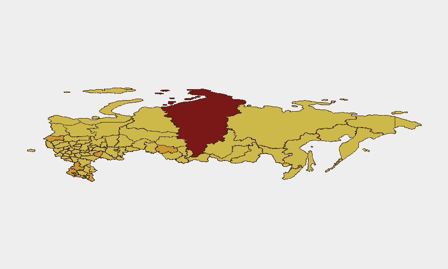
Moscow (risk 100) and Krasnoyarsk Krai (97.5) rank as the two highest-risk sub-national zones, driven by Moscow's status as the capital, seat of government, and primary target for large-scale drone operations, compounded by dense civilian and expatriate populations and critical infrastructure concentration. Rostov Oblast (72.5) and Dagestan (72.3) follow, reflecting proximity to active conflict zones and border instability; Saint Petersburg and Leningrad Oblast (71.9 and 71.7 respectively) have escalated into the top-six risk tier following the 18 June confirmation of drone strikes in the city, historically positioned as a secondary but significant military and economic target. The clustering of risk in Moscow and border/western regions reflects both the geographic proximity of the Ukraine conflict and the demonstrated ability of Ukrainian forces to project power into central Russia.
How GeoBit Would Assist
Security teams should deploy AOI Monitoring & Early Warning on Moscow, Saint Petersburg, Krasnoyarsk, and border oblasts to receive real-time alerting on drone activity, military movements, and strike events. Intel Sweep and OSINT fusion (X/Twitter, Telegram, YouTube OSINT, and multi-language feeds) combined with temporal and sentiment analysis provide 4–6 hour lead time on emerging threats before official announcements. Routing & Network Analysis can identify safe corridors and alternative transit routes for personnel evacuation or supply chains away from high-risk zones.
7-Day Outlook
Drone strikes targeting Moscow and major cities are likely to persist at current or elevated operational tempo over the next 7 days, with no cease-fire signals or diplomatic off-ramps evident. Risk to personnel and supply-chain continuity in Moscow, Saint Petersburg, and border regions will remain acute; any escalation in NATO–Russian conventional engagements could trigger broader emergency measures, including airspace closures or forced departure orders. Organizations should assume heightened shelter-in-place requirements and communication delays in major urban centers through at least 25 June.
Highest-Risk Areas — Ranked
| # | State / Region | Risk |
|---|---|---|
| 1 | Moscow | 100 |
| 2 | Krasnoyarsk Krai | 97.5 |
| 3 | Rostov Oblast | 72.5 |
| 4 | Dagestan | 72.3 |
| 5 | Saint Petersburg | 71.9 |
| 6 | Leningrad Oblast | 71.7 |
| 7 | Samara Oblast | 71.2 |
| 8 | Krasnodar Krai | 71.1 |
| 9 | Novosibirsk Oblast | 71 |
| 10 | Kaliningrad | 70.9 |
| 11 | Tver Oblast | 70.9 |
| 12 | Volgograd Oblast | 70.9 |
Sources
Previous Daily Briefs
A new Russia brief is written every day — each with its own risk map and downloadable CSV. Here's the last week; use the calendar to go further back.
📅 Browse every day by calendar →
Highlighted days have a brief. Tap a day for that day's map & analysis, or “csv” for that day's dataset ($5).