Situation Summary
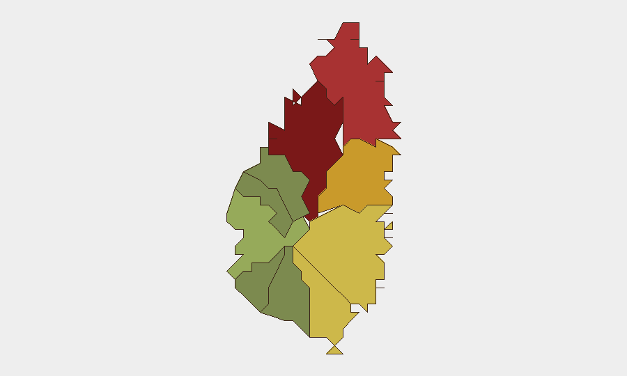
Saint Lucia remains a low-frequency threat environment globally (composite threat score 2), with no tracked discrete security events in the current reporting window. However, the U.S. State Department's July 2026 escalation to Level 2 travel advisory—citing violent crime including armed robbery, assault, burglary, and rape—signals persistent baseline risk. Risk is highly concentrated in Castries (capital, risk score 95) and the northern coastal districts; peripheral and rural zones show substantially lower threat profiles.
Key Developments
- U.S. Travel Advisory Upgrade (2026-07-10 to ongoing). The U.S. State Department raised Saint Lucia to Level 2 ("Exercise Increased Caution") and added a crime indicator. The advisory cites armed robbery, assault, burglary, and rape as principal concerns and has received regional media repetition, affecting tourism and business sentiment.
- No Confirmed Incident in Last 48 Hours. Available web research does not identify a specific, independently verifiable security incident in Saint Lucia within the last 48 hours that would have triggered new alerts or policy shifts. The advisory reflects sustained risk profile rather than acute triggering event.
- Economic/Tourism Sector Sensitivity. Regional coverage notes concern for the tourism-dependent economy following the advisory escalation; however, no operational disruption or specific business impact has been reported in the current 24–48-hour window.
Highest-Risk Areas
Castries (risk 95) and Gros Islet (risk 78) drive the majority of tracked risk, reflecting their status as the capital and primary commercial and tourism hub. Dennery (72), Vieux Fort (68), and Micoud (65) form a secondary tier, likely reflecting urban density, transient populations, and property-crime exposure. Peripheral districts—Canaries (12), Anse La Raye (28), Choiseul (35)—show materially lower risk profiles. Risk concentration in urban centers aligns with the crime indicators (robbery, assault) cited in the U.S. advisory and suggests that duty-of-care focus should prioritize staff and asset presence in Castries and the northern coast.
How GeoBit Would Assist
Security teams with personnel or assets in Saint Lucia should employ AOI (Area-of-Interest) Monitoring & Early Warning on Castries, the port authority zone, and key commercial districts to detect emerging incident patterns and crime-trend shifts. Intel Sweep and multi-language OSINT fusion (X/Twitter, local news, regional security reporting) provide real-time visibility into crime events, gang activity, and travel-advisory updates that may affect staff movement or asset security. Risk & Threat Assessment and Routing & Network Analysis capabilities enable identification of safer commute corridors and alternative site access routes in higher-risk districts.
7-Day Outlook
No acute security escalation is forecast for the next seven days. The baseline crime risk reflected in the U.S. advisory is expected to persist; however, absent new incident reporting or policy shifts, operational and travel patterns should stabilize. Security teams should continue standard duty-of-care protocols (staff awareness, secure transportation, restricted movement in Castries after dark) and monitor the U.S. State Department and local law-enforcement channels for any advisory upgrade or new incident cluster.
Highest-Risk Areas — Ranked
| # | State / Region | Risk |
|---|---|---|
| 1 | Castries | 95 |
| 2 | Gros Islet | 78 |
| 3 | Dennery | 72 |
| 4 | Vieux Fort | 68 |
| 5 | Micoud | 65 |
| 6 | Soufrière | 42 |
| 7 | Laborie | 38 |
| 8 | Choiseul | 35 |
| 9 | Anse La Raye | 28 |
| 10 | Canaries | 12 |
Sources
Previous Daily Briefs
A new Saint Lucia brief is written every day — each with its own risk map and downloadable CSV. Here's the last week; use the calendar to go further back.
📅 Browse every day by calendar →
Highlighted days have a brief. Tap a day for that day's map & analysis, or “csv” for that day's dataset ($5).
Atlas — our AI intelligence desk — emails them this snapshot personally. Nothing else, no list.