Situation Summary
Samoa presents a low and stable security environment as of 5 August 2026, with no significant incidents of violent crime, civil unrest, political instability, or infrastructure disruption reported in the past 48 hours. The country's composite threat score of 21 places it outside the global top-risk tier, and routine police and security activity dominates current reporting. Near-term risk trajectory remains flat, with operating conditions suitable for normal business and travel under standard precautions.
Key Developments
- Faleolo International Airport, Aiga-i-le-Tai – 4 August 2026
Samoa Police, Prisons & Corrections Services (SPPCS) formally opened a new Airport K9 Office and enhanced border security screening facility, supported by Australian Government funding. This represents a capacity-building step in port-of-entry security infrastructure.
- Tuanaimato, Apia – 4 August 2026
Official opening of a new SPPCS Assets & ICT warehouse, also funded by Australia, improving logistics and equipment management for police and corrections operations across the country.
- Safata II constituency, south-west Upolu – early August 2026
SPPCS confirmed full deployment of officers for duties during the Safata II by-election. No security incidents or unrest linked to the electoral process have been reported.
- Tanugamanono, Apia – early August 2026
Three males from Tanugamanono were arrested and charged in connection with an alleged robbery of a 20-year-old male in front of a supermarket. SPPCS characterized the incident as serious and isolated; suspects were scheduled for court appearance.
- Country-wide assessment – 3–5 August 2026
Multi-source monitoring (web, news, social media) corroborates no violent crime spikes, protests, political crises, natural disasters, or major infrastructure disruptions in the past 48 hours.
Highest-Risk Areas
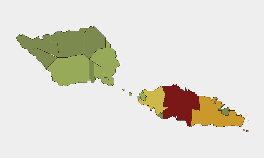
Tuamasaga (risk 85) and Ātua (risk 71) dominate sub-national risk rankings and warrant focused monitoring; both regions contain or adjoin Apia, Samoa's capital and commercial hub. Tuamasaga's higher score likely reflects urban crime density, transient populations, and economic activity concentration typical of capital regions. The next tier—Aʻana (62), Aiga-i-le-Tai (55), and Faʻasaleleaga (48)—show moderately elevated but substantially lower risk; outer and smaller districts (Vaisigano, Vaʻa-o-Fonoti) carry minimal scores. Risk appears concentrated in Upolu's populated western districts; risk management should prioritize Apia and immediate surroundings while applying standard precautions elsewhere.
How GeoBit Would Assist
GeoBit's AOI Monitoring & Early Warning capability can sustain persistent watch over high-risk districts (Tuamasaga, Ātua) and key infrastructure sites (airports, government facilities) with real-time alerting on emerging threats. OSINT Fusion & Corroboration across social media, news, and signals—combined with sentiment & temporal analysis—enables rapid detection of civil unrest, crime clusters, or political instability before they escalate. GIS & Spatial Analysis and election monitoring tools support duty-of-care assessment during electoral events (e.g., Safata II by-election) and alternative route planning for personnel operating in higher-risk urban zones.
7-Day Outlook
No significant security deterioration is forecast over the next seven days. The Safata II by-election will complete without reported incident; routine police activity and infrastructure maintenance are expected to continue. Risk remains consistent with current baseline—low, localized, and manageable under standard corporate security protocols.
Highest-Risk Areas — Ranked
| # | State / Region | Risk |
|---|---|---|
| 1 | Tuamasaga | 85 |
| 2 | Ātua | 71 |
| 3 | Aʻana | 62 |
| 4 | Aiga-i-le-Tai | 55 |
| 5 | Faʻasaleleaga | 48 |
| 6 | Palauli | 42 |
| 7 | Satupaʻitea | 38 |
| 8 | Gagaʻemauga | 35 |
| 9 | Gagaʻifomauga | 32 |
| 10 | Vaisigano | 28 |
| 11 | Vaʻa-o-Fonoti | 23 |
Sources
Previous Daily Briefs
A new Samoa brief is written every day — each with its own risk map and downloadable CSV. Here's the last week; use the calendar to go further back.
📅 Browse every day by calendar →
Highlighted days have a brief. Tap a day for that day's map & analysis, or “csv” for that day's dataset ($5).
Atlas — our AI intelligence desk — emails them this snapshot personally. Nothing else, no list.