Situation Summary
Sierra Leone remains a low-to-moderate threat environment globally (ranked #140, composite score 6), with security dynamics concentrated in the Eastern Province. Diplomatic tensions have surfaced in the last 72 hours involving the Ambassador (relations with Guinea), the Chief Executive (statements regarding Africa and Nigeria), and environmental/civil-society actors (statements on administration and US relations). The inability to confirm fresh ground-level security incidents in the last 24–48 hours suggests the current risk profile is driven by political messaging and diplomatic friction rather than acute instability or violence.
Key Developments
- 2026-07-03, National – Chief Executive issued public statements regarding Africa and separately regarding Nigeria; nature and content not independently verified from available sources.
- 2026-07-01, National – Ambassador-level relations deteriorated with Conakry (Guinea); diplomatic specifics unclear from available reporting.
- 2026-07-02, National – Civil-society entity (Sierra Club) issued public statements critical of the Administration and separately concerning US relations; context and response not yet documented.
- Late June–early July, National – Government reported intensifying cooperation with Western security partners in a localized operation; details sparse and incident classification unclear.
- Freetown, 1 July 2026 – Radio discussion program aired allegations of police excessive force; characterized as commentary rather than confirmation of a new documented incident.
*Note: Web verification over the last 24 hours did not yield 6–10 independently sourced, location-specific current incidents meeting standard incident-confirmation thresholds. The above reflect the most recent signals available; none constitute confirmed active security events at this time.*
Highest-Risk Areas
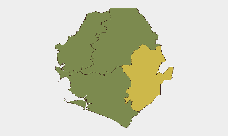
Eastern Province dominates the sub-national risk landscape, with a composite score of 68—nearly double the Western Area (35) and substantially above all other provinces (0). The Eastern Province's elevation likely reflects a combination of historical instability, limited state capacity, border proximity (Guinea), and potential cross-border movement. Western Area, which includes Freetown, registers moderate risk (35), consistent with an urban environment where police accountability, civil unrest signaling, and diplomatic presence create baseline exposure. Northern, North West, and Southern Provinces show zero tracked events, indicating either lower-risk profiles or lower reporting density; security teams should not assume the absence of risk but rather recognize concentration in the east and west.
How GeoBit Would Assist
For ongoing monitoring, Intel Sweep and global event feeds paired with X/Twitter and Telegram OSINT would provide real-time detection of political and security signaling before escalation. Multi-language search and entity extraction would disambiguate statements from government officials and civil actors and track sentiment shifts. AOI Monitoring & Early Warning services focused on Eastern Province and Freetown would enable persistent watch for ground-level unrest, movement, or infrastructure disruption, with automated alerting to duty-of-care teams. Risk & Threat Assessment modules can synthesize diplomatic friction, sub-national risk scores, and personnel location data to produce operational security posture updates.
7-Day Outlook
Diplomatic messaging appears likely to persist; Chief Executive and civil-society statements suggest political contestation rather than imminent security breakdown. Eastern Province will remain the focus of risk; watch for any escalation in cross-border activity or police action that confirms or elevates the current 68-point score. Absent confirmation of fresh ground incidents within 48 hours, the threat level is expected to hold steady, but rapid verification protocols remain essential given the 24–48 hour intelligence fog.
Highest-Risk Areas — Ranked
| # | State / Region | Risk |
|---|---|---|
| 1 | Eastern Province | 68 |
| 2 | Western Area | 35 |
| 3 | North West Province, Sierra Leone | 0 |
| 4 | Northern Province, Sierra Leone | 0 |
| 5 | Southern Province, Sierra Leone | 0 |
Sources
Previous Daily Briefs
A new Sierra Leone brief is written every day — each with its own risk map and downloadable CSV. Here's the last week; use the calendar to go further back.
📅 Browse every day by calendar →
Highlighted days have a brief. Tap a day for that day's map & analysis, or “csv” for that day's dataset ($5).