Situation Summary
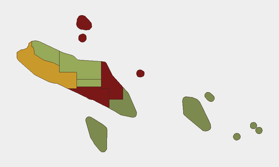
Solomon Islands remains at low overall threat level (composite score 3, no tracked events in current window), with normal transport, port, and airport operations nationwide as of 21 July. However, sub-national risk concentration in Honiara (92), Guadalcanal (88), and Malaita (85) reflects persistent violent crime concerns and localized instability. No discrete security incidents were verified in the preceding 24–48 hours; the security environment is stable but operationally fragmented by geography.
Key Developments
- Nationwide, 21 July — No verified security incidents reported in preceding 24–48 hours; transport, port, and airport operations remained normal nationwide.
- Honiara, 21 July — Prime Minister Matthew Wale concluded talks with U.S. officials on deepening bilateral ties and resuming Peace Corps operations; diplomatic engagement with security implications.
- Honiara, 22 July — Solomon Islands and the U.S. announced plans to sign a ship-rider agreement within one week to enhance maritime law enforcement and surveillance capacity.
- Nationwide, 22 July — Travel advisories continued to rate Solomon Islands as exercise-normal-safety-precautions overall, with higher alert levels only in specific areas; no fresh disruption reported.
Background context (unconfirmed date, recent):
- Central Guadalcanal has experienced violent crime incidents including assaults and arson (e.g., burning of logging and dump vehicles by masked individuals); police patrols have increased but exact incident dates are not confirmed in available reporting.
Highest-Risk Areas
Honiara and Guadalcanal drive the risk ranking (92 and 88 respectively), followed closely by Malaita (85). These three regions account for the majority of violent crime, including armed robbery, assault, and property crimes targeting commercial and residential targets. Honiara's status as the capital and primary economic hub concentrates both criminal activity and transient vulnerability; Guadalcanal's interior and rural areas report intermittent gang activity and arson. Western Province (72) and Choiseul (58) show elevated but secondary risk. The remaining provinces (Central, Makira-Ulawa, Rennell/Bellona, Temotu) carry substantially lower risk, making them relatively safer for operations and transit.
How GeoBit Would Assist
Teams with personnel or assets in Honiara, Guadalcanal, or Malaita should employ AOI Monitoring & Early Warning (persistent watch on high-risk zones with alerting) and Intel Sweep (global event feeds and X/Twitter OSINT) to detect emerging crime patterns or civil unrest before escalation. Routing & Network Analysis can identify safer alternative routes for staff movement and supply chains, particularly in Guadalcanal and Western Province. OSINT fusion and multi-language search supports real-time monitoring of local reporting and social-media signals in areas where English-language reporting is sparse, enabling faster situational awareness for duty-of-care assessments.
7-Day Outlook
No imminent security deterioration is forecast. The U.S.–Solomon Islands maritime cooperation agreement signals international commitment to regional stability and law enforcement; however, implementation timelines are unclear. Violent crime in Honiara and Guadalcanal is likely to remain endemic at current levels absent major police or justice reforms. Teams should maintain standard vigilance protocols in high-risk provinces and monitor for any disruptions linked to logging disputes or resource-access tensions in Central Guadalcanal.
Highest-Risk Areas — Ranked
| # | State / Region | Risk |
|---|---|---|
| 1 | Honiara | 92 |
| 2 | Guadalcanal | 88 |
| 3 | Malaita | 85 |
| 4 | Western | 72 |
| 5 | Choiseul | 58 |
| 6 | Isabel | 52 |
| 7 | Central Province | 48 |
| 8 | Makira-Ulawa | 38 |
| 9 | Rennell and Bellona | 22 |
| 10 | Temotu | 18 |
Sources
Previous Daily Briefs
A new Solomon Islands brief is written every day — each with its own risk map and downloadable CSV. Here's the last week; use the calendar to go further back.
📅 Browse every day by calendar →
Highlighted days have a brief. Tap a day for that day's map & analysis, or “csv” for that day's dataset ($5).
Atlas — our AI intelligence desk — emails them this snapshot personally. Nothing else, no list.