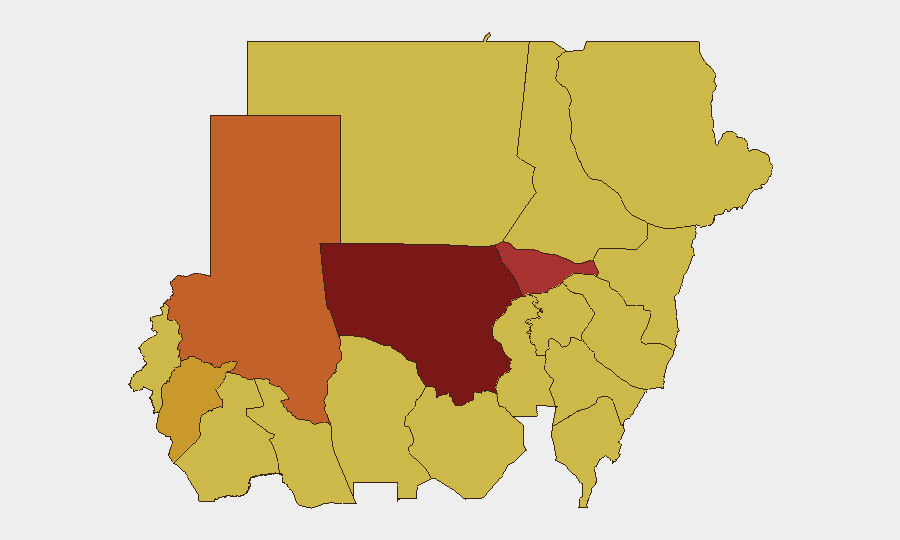
Situation Summary
Sudan remains in active civil war between the Sudanese Armed Forces (SAF) and the Rapid Support Forces (RSF), with conflict intensity and geographic scope showing no signs of abatement as of mid-June 2026. The conflict is generating sustained conventional military operations, drone strikes, civilian casualties, mass displacement, and systematic conflict-related sexual violence across multiple states. International diplomatic efforts from SAF leadership are ongoing but have not produced observable ceasefire progress, and regional military mobilization signals suggest operational tempo may intensify in coming days.
Key Developments
- El Obeid, North Kordofan (June 18–19): RSF has repositioned several dozen armored vehicles and air-defence assets to positions south and west of El Obeid near Kazgil and Um Sumeima, with sustained drone strikes on the city reported causing dozens of civilian casualties and destruction of fuel infrastructure. SAF has responded with counter-drone and reported ground operations.
- El Obeid, North Kordofan (June 18–19): Intelligence and humanitarian sources indicate fears of an imminent RSF ground offensive against the SAF-held stronghold, suggesting a major tactical shift may be underway in this region.
- Urshi town, North Darfur (reported June 14–15, within last 48h): RSF forces conducted an assault on the town targeting civilians, resulting in multiple fatalities including women and children; regional authorities characterize it as a serious atrocity with indicators of ethnic-targeted violence.
- South Darfur State (June 18–19): RSF deployed heavy reinforcements to contain intra-community civil conflict, with at least 36 reported killed; RSF given broad authority to use force and arrest members of both warring factions.
- Kosti, White Nile State (June 19): Sudanese Red Crescent and partners distributed aid to 1,462 displaced families at Guz Al Salam IDP camp, reflecting ongoing large-scale displacement driven by conflict.
- Nationwide (June 18–19): UN Women and UN human rights mechanisms report conflict-related sexual violence against women and girls at high and rising levels, with case numbers roughly doubling compared to earlier periods in the conflict.
- Port Sudan, Red Sea State (June 18): SAF Commander al-Burhan continues high-level diplomatic engagement with international partners, including recent EU ambassador meetings, aimed at securing ceasefire and humanitarian access commitments.
Highest-Risk Areas
North Kordofan State (composite risk 100) is the single highest-risk location, driven by the active RSF military buildup and drone campaign targeting El Obeid. Al Khartum (77.5) and the three Darfur states (North 73.8, Central 71.9, South 70) follow, where conventional military operations, ethnic dynamics, intra-communal violence, and documented atrocities are concentrated. The remaining tier of eight states (Blue Nile, River Nile, Aj Jazira, Red Sea, Al Qadarif, Kassala, Sennar, South Darfur) all register composite risk of 70, reflecting the conflict's nationwide footprint and sustained displacement and humanitarian access constraints.
How GeoBit Would Assist
Corporate security and duty-of-care teams with personnel or assets in Sudan should employ Battle Mapping and Force Structure tracking to monitor SAF and RSF redeployments in real time, AOI (Area-of-Interest) Monitoring with persistent alerting on highest-risk states and logistics nodes, and Satellite & Imagery analysis to track military positioning and infrastructure damage. Humanitarian & NGO data integration and Alternative Route & Network Analysis are critical for evacuation planning and movement of personnel through conflict zones.
7-Day Outlook
The RSF buildup around El Obeid and related drone intensity suggest a major tactical operation is likely within the next 7–10 days. Simultaneously, documented sexual violence and atrocities in Darfur and North Darfur indicate a sustained asymmetric conflict character. International diplomatic engagement from Port Sudan shows no signs of producing imminent de-escalation; risk of renewed or widened conventional engagements remains elevated.
Highest-Risk Areas — Ranked
| # | State / Region | Risk |
|---|---|---|
| 1 | North Kordofan State | 100 |
| 2 | Al Khartum | 77.5 |
| 3 | North Darfur State | 73.8 |
| 4 | Central Darfur State | 71.9 |
| 5 | Blue Nile | 70 |
| 6 | River Nile State | 70 |
| 7 | Aj Jazira | 70 |
| 8 | Red Sea State | 70 |
| 9 | Al Qadarif State | 70 |
| 10 | Kassala State | 70 |
| 11 | Sennar State | 70 |
| 12 | South Darfur State | 70 |
Sources
Previous Daily Briefs
A new Sudan brief is written every day — each with its own risk map and downloadable CSV. Here's the last week; use the calendar to go further back.
📅 Browse every day by calendar →
Highlighted days have a brief. Tap a day for that day's map & analysis, or “csv” for that day's dataset ($5).