Situation Summary
Suriname remains a low-to-moderate threat environment globally (#85 composite threat score) with no acute security incidents documented in the past 24–48 hours. The country's risk profile is stable at baseline, characterized by persistent but non-escalating challenges in interior gold-mining zones and routine urban crime in coastal urban centers. Near-term trajectory shows no indicators of sudden deterioration, though structural vulnerabilities in remote districts warrant continued monitoring.
Key Developments
- Paramaribo – 24 Jul 2026: A demonstration or rally involving the Prime Minister was recorded in Paramaribo; no reports of violence, disruption, or security force escalation are available in open sources.
- Countrywide – 24–25 Jul 2026: No verified location-specific security incidents (armed clashes, mass crime events, infrastructure failures, or civil unrest escalations) are documented across monitored districts in this window.
- Interior gold-mining zones – 24–25 Jul 2026: National-level monitoring continues to flag persistent "order problems" (*ordeproblemen*) as an ongoing structural issue rather than a new or dated incident; no specific attacks or clashes are identified in the last 48 hours.
- Paramaribo & Marowijne – 24–25 Jul 2026: Urban security remains at baseline levels; routine crime risk is elevated in Paramaribo and Marowijne relative to other districts, but no major escalation, mass robbery, riot, or targeted attack is reported.
- Travel advisory environment – 24–25 Jul 2026: No new travel warnings or advisories specific to Suriname have been issued by diplomatic missions or multilateral bodies in the last 24–48 hours.
Highest-Risk Areas
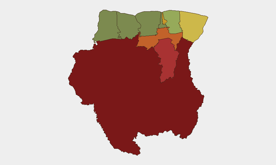
Sipaliwini (risk 92), Brokopondo (78), and Para (74) are the primary risk drivers, all located in the interior and associated with gold-mining activity, informal settlement, armed group presence, and weak state capacity. Paramaribo (71) and Marowijne (68) on the coast reflect urbanization, higher population density, and routine street crime and gang activity. Remote interior districts lack law enforcement reach and are subject to competition for natural resources; coastal areas face conventional urban-crime pressures. Western districts (Saramacca, Coronie, Nickerie) present substantially lower risk.
How GeoBit Would Assist
Corporate security and duty-of-care teams operating in Suriname would benefit from AOI Monitoring & Early Warning set on high-risk interior districts (Sipaliwini, Brokopondo, Para) to detect emerging armed-group activity, mining disputes, or trafficking flows in near-real time. Intel Sweep, OSINT fusion, and multi-language search across local media, radio SIGINT, and social platforms would enable continuous baseline tracking of civil unrest, crime patterns, and enforcement actions in Paramaribo and coastal zones. Routing & Network Analysis and satellite imagery support alternative-route planning and asset positioning in interior operations, minimizing exposure to high-friction zones.
7-Day Outlook
No acute deterioration is anticipated in the next 7 days. Baseline risk in interior mining zones and coastal urban crime will persist; structural governance and resource-competition issues remain unresolved. Continued monitoring of political statements, regional gang activity, and enforcement operations in Paramaribo and mining districts is warranted as routine practice.
*This brief reflects open-source intelligence and does not substitute for classified, proprietary, or human intelligence. For operational questions, contact your GeoBit account team.*
Highest-Risk Areas — Ranked
| # | State / Region | Risk |
|---|---|---|
| 1 | Sipaliwini | 92 |
| 2 | Brokopondo | 78 |
| 3 | Para | 74 |
| 4 | Paramaribo | 71 |
| 5 | Marowijne | 68 |
| 6 | Commewijne | 42 |
| 7 | Wanica | 38 |
| 8 | Saramacca | 29 |
| 9 | Coronie | 12 |
| 10 | Nickerie | 8 |
Sources
Previous Daily Briefs
A new Suriname brief is written every day — each with its own risk map and downloadable CSV. Here's the last week; use the calendar to go further back.
📅 Browse every day by calendar →
Highlighted days have a brief. Tap a day for that day's map & analysis, or “csv” for that day's dataset ($5).
Atlas — our AI intelligence desk — emails them this snapshot personally. Nothing else, no list.