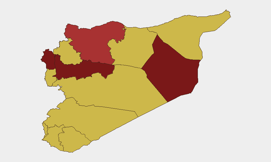
Situation Summary
Syria remains the fourth-highest global threat environment, driven by ongoing civil conflict and fragmented state control. The last 48 hours show mixed signals: Israeli-Syrian relations have deteriorated, Iran has issued military threats, and the UN World Food Program has reduced operations—all indicating widening instability. Counterterrorism operations continue against ISIS cells in Raqqa and rural Damascus, while border militarization near Lebanon suggests preparation for potential regional escalation.
Key Developments
- Israel–Syria Relations Deterioration (2026-06-17). Israel has reduced diplomatic relations with Syria; concurrent reporting indicates Israeli forces maintain de facto control of approximately 235 km² in Syrian territory designated as "security zones," with no announced withdrawal timeline.
- Iran Military Threat (2026-06-18). Iran has issued a direct military threat against Syrian military assets or personnel, signaling deepened tensions within the Iranian-Syrian alliance and potential for escalated proxy activity.
- UN World Food Program Operational Reduction (2026-06-18). WFP has reduced operations across Syrian territory, likely due to security degradation and access constraints; this signals deteriorating humanitarian conditions and restricted movement corridors.
- ISIS Counterterrorism Activity (2026-06-15, Raqqa). ISIS operatives attacked an internal security facility in Raqqa, killing one security officer and wounding several; concurrent reporting from rural Damascus (2026-06-16) shows ISIS operatives wounded a judicial official, indicating sustained ISIS operational capability despite territorial losses.
- Border Militarization (Timing unconfirmed, western Homs/south Tartus). Reports indicate Syrian military deployment of thousands of troops and rocket units along the Lebanon border in response to regional tensions; exact date of deployment not independently verified in the last 48 hours, but consistent with escalation signals from Israel and Iran activity.
- Regime Security Operations (2026-06-12 to 2026-06-14 range). Syrian authorities arrested a former Al-Quds Brigade commander on war crimes and drug trafficking charges, and detained a former brigadier general and ex-deputy director of State Security; these arrests suggest ongoing internal consolidation or purges within security apparatus.
Highest-Risk Areas
Hama Governorate (risk 100) and Damascus Governorate (risk 98) dominate the threat landscape. Hama's rank reflects sustained multi-faction armed presence and limited state control; Damascus's rank reflects both ISIS operational activity and political volatility centered on the capital. Deir ez-Zor (85.7) remains high due to ISIS presence and proximity to Iraq border; Lattakia (82.4) and Aleppo (79.1) face compounded risk from Israeli military pressure, Iranian militia positioning, and Turkish border dynamics. The UNDOF-patrolled zone (77.8) and Tartus (70) show elevated risk tied to regional militarization and strategic military infrastructure.
How GeoBit Would Assist
Security teams with personnel or assets in Syria should employ AOI Monitoring & Early Warning on Hama, Damascus, and border zones to detect force movements and clash patterns in real time. Conflict & Military capabilities—force structure tracking and weapons capability analysis—would clarify Iranian militia distribution and Israeli operational posture. Network & Actor Analysis combined with OSINT fusion (X/Telegram feeds, multi-language search, entity extraction) would track regime arrest patterns, ISIS splinter activity, and cross-border militia coordination to anticipate second and third-order effects.
7-Day Outlook
Regional escalation risk remains elevated. Israeli-Syrian military pressure, Iranian threats, and border buildup suggest potential for direct military incidents within 7 days, particularly in Lattakia, Tartus, or Hama. ISIS will likely continue opportunistic strikes against security forces. Humanitarian operations may contract further, increasing civilian exposure and displacement risk.
Highest-Risk Areas — Ranked
| # | State / Region | Risk |
|---|---|---|
| 1 | Hama Governorate | 100 |
| 2 | Damascus Governorate | 98 |
| 3 | Deir ez-Zor Governorate | 85.7 |
| 4 | Lattakia Governorate | 82.4 |
| 5 | Aleppo Governorate | 79.1 |
| 6 | UNDOF | 77.8 |
| 7 | Tartus Governorate | 70 |
| 8 | Al-Quneitra Governorate | 70 |
| 9 | Dar'a Governorate | 70 |
| 10 | Idleb Governorate | 70 |
| 11 | Ar-Raqqa Governorate | 70 |
| 12 | Homs Governorate | 70 |
Sources
Previous Daily Briefs
A new Syria brief is written every day — each with its own risk map and downloadable CSV. Here's the last week; use the calendar to go further back.
📅 Browse every day by calendar →
Highlighted days have a brief. Tap a day for that day's map & analysis, or “csv” for that day's dataset ($5).