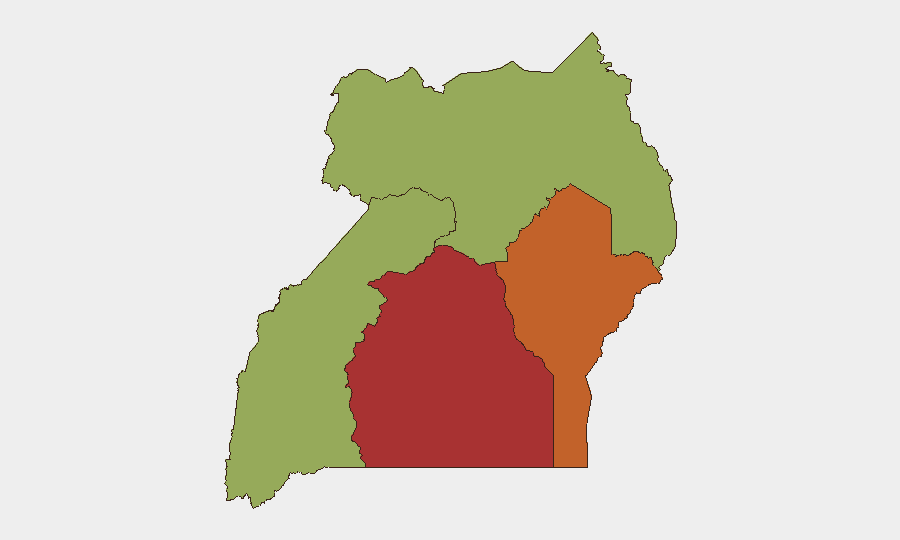
Situation Summary
Uganda remains a mid-tier global security concern (rank #19, composite threat score 69) with violent crime, armed robbery, and firearms theft the dominant near-term drivers of risk in central urban and peri-urban zones. The Central Region dominates threat metrics (risk 78), reflecting concentrated criminal activity in the Kampala–Wakiso corridor and surrounding districts. Recent law enforcement operations have yielded significant arrests (1,711 suspects in two weeks across Greater Kampala), indicating both elevated criminal activity and active state response; however, the theft of a security firearm in Mubende District on July 25 and the emergence of organized stolen-electronics networks underscores persistent capability gaps in asset protection and supply-chain security.
Key Developments
- Nsangi, Wakiso District (July 26–27, reported July 29): Armed assailants conducted an aggravated robbery and rape attack on residents in Kyengera Town Council; Uganda Police arrested 11 suspects and detained them at Kikajo Police Post under Nsangi Police Station.
- Kagavu Village, Mubende District (July 25, ongoing): Armed attackers fatally injured private security guard Joseph Mutegule at an Artica Coffee International storage facility and stole a Securico-issued rifle (serial UG30373337E104297) with three rounds of ammunition; Regional Flying Squad Unit manhunt is active to prevent further use of the firearm.
- Kampala stolen-electronics network (July 18–21): Following an iPhone theft at Top City Plaza on an unspecified date, police arrested suspect Richard Mugabi on July 18 in Kakajo, Kisenyi Cell; subsequent raids on July 21 uncovered 120 suspected stolen iPhones, multiple iPads, laptops, and phone-resetting equipment linked to suspect Juma Mugerwa.
- Kampala Metropolitan Area (July 13–26): Police reported 1,711 arrests in violent crime and gang-activity operations across Greater Kampala, including targeted enforcement in Kikajjo Zone (Makindye–Ssabagabo) and Namasuba Parish, Wakiso District.
- Lukira Village, Kassanda District (July 2, arrests announced July 24): Police arrested five suspects linked to a robbery–double homicide in which two workers (Joseph Ssali and Regina Mariza) were killed; suspects were tracked from Masaka City to Kassanda District and remain in custody.
- Madi–Okollo District (July 25): Security forces conducted a joint operation to enforce a ban on commercial charcoal production across Karamoja, Teso, Lango, Acholi, and West Nile sub-regions, impounding illegal charcoal and arresting eight individuals.
- Nationwide health status (July 28): Uganda's health minister declared the country Ebola-free after completion of the 42-day monitoring period; however, foreign travel advisories continue to flag elevated travel risk due to residual epidemiological and security concerns.
Highest-Risk Areas
The Central Region (risk 78) and Eastern Region (risk 73.1) account for the majority of tracked security events, with violent crime, armed robbery, and organized theft concentrated in urban and peri-urban corridors linking Kampala, Wakiso, Mubende, and Kassanda districts. Central Region's dominance reflects both population density and the operational footprint of urban criminal networks targeting commercial supply chains (coffee, electronics, cash), private security assets, and residential areas. Eastern Region elevation reflects secondary crime spillover and enforcement activity. Western (50.7) and Northern (49) regions remain below the national average, though Northern operations targeting resource extraction (charcoal) suggest emerging friction between enforcement and livelihood-dependent populations.
How GeoBit Would Assist
Security and duty-of-care teams would deploy AOI Monitoring & Early Warning on high-risk commercial corridors (Kampala–Wakiso–Mubende) with automated alerting on violent incidents, firearms theft, and organized crime activity. Conflict & Military tracking, entity extraction, and network analysis would map criminal supply chains and identify emerging organized-crime cells. Alternative routing & journey planning would enable real-time avoidance of robbery hotspots and enforcement operations affecting staff mobility and supply logistics.
7-Day Outlook
Violent crime in central Uganda is likely to remain elevated and reactive to police enforcement cycles; the stolen firearm in Mubende presents a secondary risk vector if used in further attacks. No large-scale civil unrest or political-violence incidents are currently signaled, but continued pressure on Northern livelihoods (charcoal ban) may generate localized friction. Corporate assets in Kampala–Wakiso remain the primary exposure vector.
Highest-Risk Areas — Ranked
| # | State / Region | Risk |
|---|---|---|
| 1 | Central Region | 78 |
| 2 | Eastern Region | 73.1 |
| 3 | Western Region | 50.7 |
| 4 | Northern Region | 49 |
Sources
Previous Daily Briefs
A new Uganda brief is written every day — each with its own risk map and downloadable CSV. Here's the last week; use the calendar to go further back.
📅 Browse every day by calendar →
Highlighted days have a brief. Tap a day for that day's map & analysis, or “csv” for that day's dataset ($5).
Atlas — our AI intelligence desk — emails them this snapshot personally. Nothing else, no list.