Situation Summary
Ukraine remains the 7th-highest-threat environment globally, with 1,181 tracked security events and a composite threat score of 100. Overnight June 23–24, Ukrainian forces executed a sustained campaign of long-range strikes deep into Russian territory—targeting energy infrastructure, satellite communications, and military facilities—while Russia responded with 101 long-range attack drones and claimed interception of 323 Ukrainian drones. Simultaneous Russian strikes on Ukrainian cities (including Kryvyi Rih, where cluster-munition casualties rose to four) and ongoing combat operations in and around Crimea underscore a conflict at high operational tempo with expanding geographic scope and persistent threat to civilian infrastructure.
Key Developments
- Orenburg region, Russia (night June 23–24): Ukrainian forces struck the Orenburg Gas Processing Plant and Russia's helium production facility, igniting fires and damaging critical energy infrastructure supplying regional industrial operations.
- Dubna and Vladimir regions, Russia (night June 23–24): Ukraine targeted the Dubna Space Communications Center (Russia's largest ground-based satellite communications complex near Moscow) and a second military satellite communications facility in Vladimir region, degrading Russian command-and-control systems.
- Sevastopol, occupied Crimea (night June 23–24): Ukrainian drone strikes knocked out electrical power in Sevastopol, causing direct disruption to civilian services across the occupied city.
- Crimea military airfields (night June 23–24): Ukraine's Security Service reported strikes on two military airfields in Crimea, claiming destruction of missile systems and air-defense assets.
- Nizhny Novgorod region, Russia (night June 23–24): A Ukrainian drone strike killed two civilians and wounded two others, extending lethal operations well beyond the conflict frontline.
- Kryvyi Rih, Ukraine (casualty update June 24, attack June 23): The death toll from a Russian ballistic missile strike using cluster munitions rose to four after a 62-year-old woman succumbed to injuries sustained in the attack on a civilian area.
- Ukraine–Russia airspace (night June 23–24): Russia claimed interception of 323 Ukrainian drones; Ukraine's air force reported Russia launched 101 long-range attack drones, indicating very high aerial activity and mutual strike operations across contested regions.
Highest-Risk Areas
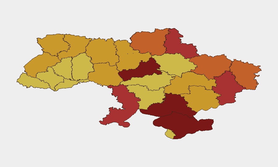
Kyiv (risk 100) and Cherkasy Oblast (98.5) remain the most acute threat zones, driven by concentration of national government, infrastructure, and military command-and-control targets, combined with persistent Russian air and missile campaigns. Crimea (85.8) and Kherson Oblast (83.9) face elevated risk from active combat operations, occupation-related security fragmentation, and infrastructure targeting. The eastern frontline zones—Donetsk, Sumy, Luhansk, and Kharkiv oblasts—sustain risk scores of 74–78 due to conventional military force concentration, while southern regions including Odesa face hybrid threats spanning maritime activity, drone strikes, and supply-line disruption.
How GeoBit Would Assist
Security teams protecting personnel or assets in Ukraine should employ AOI Monitoring & Early Warning to track real-time drone and missile activity in proximity to operations; Conflict & Military modules (battle mapping, weapons-capability tracking) to anticipate strike patterns and frontline volatility; and Routing & Network Analysis for alternative travel corridors as infrastructure and airspace risk fluctuates. Intel Sweep and multi-language OSINT fusion provide corroboration of Ukrainian and Russian claims and detection of escalatory signals before they manifest operationally.
7-Day Outlook
The tempo of strategic strikes by both sides is likely to persist over the next week, with Ukrainian operations continuing to target Russian energy and communications assets and Russian retaliation focusing on Ukrainian cities and infrastructure. Risk to civilian populations and essential services will remain elevated across Kyiv, the southern and eastern oblasts, and occupied territories; personnel in these zones should maintain heightened situational awareness and contingency transit plans.
Highest-Risk Areas — Ranked
| # | State / Region | Risk |
|---|---|---|
| 1 | Kyiv | 100 |
| 2 | Cherkasy Oblast | 98.5 |
| 3 | Autonomous Republic of Crimea | 85.8 |
| 4 | Kherson Oblast | 83.9 |
| 5 | Donetsk Oblast | 77.8 |
| 6 | Sumy Oblast | 76.8 |
| 7 | Odesa Oblast | 76.1 |
| 8 | Luhansk Oblast | 75.1 |
| 9 | Kharkiv Oblast | 74.6 |
| 10 | Chernihiv Oblast | 73.9 |
| 11 | Volyn Oblast | 72.3 |
| 12 | Vinnytsia Oblast | 71.5 |
Sources
Previous Daily Briefs
A new Ukraine brief is written every day — each with its own risk map and downloadable CSV. Here's the last week; use the calendar to go further back.
📅 Browse every day by calendar →
Highlighted days have a brief. Tap a day for that day's map & analysis, or “csv” for that day's dataset ($5).