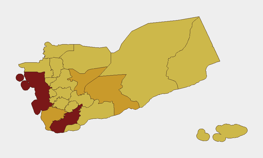
Situation Summary
Yemen remains the fifth-highest-threat country globally, driven by active armed conflict across multiple governorates and political fragmentation between Houthi-controlled northern territory and the internationally recognized government in the south. The past 48 hours have seen a spike in targeted killings, security operations, and inflammatory rhetoric around the Red Sea, signaling intensified factional competition and heightened risk of both internal violence and maritime escalation. Humanitarian conditions continue to deteriorate, with cholera outbreaks and water-system collapse compounding displacement and disease risk. The trajectory is toward continued volatility rather than resolution.
Key Developments
- Sanaa assassination (night of 27–28 June 2026): A senior Houthi-affiliated official was killed in a targeted attack in Sanaa city; local commentators have speculated about possible foreign intelligence involvement, though attribution remains unconfirmed. This follows a pattern of high-level eliminations that typically trigger internal security crackdowns.
- Aden security move (28 June 2026): Aden Security announced that a Houthi-linked cell was responsible for the killing of a Social Fund for Development official; suspects were reportedly identified or detained, signaling ongoing covert operations targeting government-affiliated personnel.
- Sanaa checkpoint escalation (28 June 2026): Central Sanaa experienced increased vehicle searches and security checkpoints following the assassination, reflecting a short-term hardening of Houthi internal security and probable delays for transit and humanitarian operations.
- Houthi maritime threat statement (27–28 June 2026): Houthi leader Abdul-Malik al-Houthi reiterated in a televised address that the group views Israeli or perceived Western presence near Bab al-Mandeb and Somaliland as a military threat, raising the risk of attacks on shipping or infrastructure in the Red Sea corridor.
- Aden judicial friction (28 June 2026): New arrest warrants and judicial measures against a former senior tax official in Aden were reported as part of wider power struggles between government and southern authorities; analysts warn these steps risk sparking localized unrest and stalling governance.
- Sanaa operational controls tightening (late June 2026): NGO and humanitarian briefings describe heightened bureaucratic and security-service involvement in movement and program approvals in Houthi-controlled Sanaa, increasing friction for international organizations.
Highest-Risk Areas
Lahij and Al Hudaydah governorates (risk scores 100 and 96.2, respectively) are the primary drivers of Yemen's composite threat ranking, with Lahij showing the highest risk profile. Amanat Al Asimah (Sanaa city, risk 76.2) has emerged as a focal point for targeted violence and internal security operations, while Marib, Ta'izz, and Shabwah remain active conflict zones with competing armed actors. The concentration of risk in the northwest (Sanaa, Al Hudaydah, Hajjah, Sa'dah, 'Amran) reflects ongoing Houthi military control and periodic airstrikes, whereas the south and east (Aden, Shabwah, Marib) are characterized by fragmentation, criminality, and counter-terrorism operations.
How GeoBit Would Assist
A corporate security team with personnel or assets in Yemen should use GeoBit's AOI Monitoring & Early Warning to track Sanaa, Aden, and key ports (Hudaydah, Aden) for emerging threats in real time. Network & Actor Analysis combined with OSINT fusion would help map factional and militant cells, including Houthi-linked groups, to assess proximity to staff or facilities. Routing & Network Analysis and Maritime tracking are critical for alternative supply-chain and evacuation planning, especially given escalating Red Sea rhetoric and checkpoint density.
7-Day Outlook
Over the next week, expect continued internal-security operations in Sanaa and Aden as factional rivalries intensify, with elevated risk of targeted killings and arrests among government and business figures. Red Sea maritime risk will remain elevated due to Houthi signaling; shipping and supply-chain operators should assume increased boarding delays and potential interdiction. Humanitarian conditions will likely worsen, increasing displacement and disease pressure, which may trigger secondary security incidents around aid distribution points.
Highest-Risk Areas — Ranked
| # | State / Region | Risk |
|---|---|---|
| 1 | Lahij Governorate | 100 |
| 2 | Al Hudaydah Governorate | 96.2 |
| 3 | Amanat Al Asimah | 76.2 |
| 4 | Marib Governorate | 72.5 |
| 5 | Ta'izz Governorate | 71.2 |
| 6 | Shabwah Governorate | 71.2 |
| 7 | Sa'dah Governorate | 70 |
| 8 | Hajjah Governorate | 70 |
| 9 | Al Mahwit Governorate | 70 |
| 10 | 'Amran Governorate | 70 |
| 11 | Sana'a Governorate | 70 |
| 12 | Raymah Governorate | 70 |
Sources
Previous Daily Briefs
A new Yemen brief is written every day — each with its own risk map and downloadable CSV. Here's the last week; use the calendar to go further back.
📅 Browse every day by calendar →
Highlighted days have a brief. Tap a day for that day's map & analysis, or “csv” for that day's dataset ($5).