Situation Summary
Lesotho remains a low-threat environment globally (rank #159), with no major security incidents recorded in the past week. The country's primary risk drivers are localized corruption, cross-border criminal networks, and informal-economy vulnerabilities, concentrated in border districts and the capital. Institutional capacity-building—evidenced by the Directorate on Corruption and Economic Offences' new INTERPOL cooperation agreement—signals incremental strengthening of law-enforcement coordination against transnational crime.
Key Developments
- Maseru Port of Entry, 14 October 2026: A South African Border Management Authority official was arrested with 22 stamped passports belonging to Lesotho nationals and R2,100 in cash, allegedly operating a visa-extension fraud scheme. The incident underscores vulnerability in document-integrity controls at the primary land crossing between Lesotho and South Africa.
- Maseru, 18 October 2026: Lesotho's Directorate on Corruption and Economic Offences formalized a cooperation agreement with INTERPOL, granting local investigators access to international criminal-information systems for tracking suspects, illicit arms trafficking, and cross-border financial crime. This represents a capacity expansion in Lesotho's anti-corruption and financial-crime framework.
- Odendaalsrus, Free State (South Africa), 14 October 2026: Six Lesotho nationals appeared in court following arrests on 12 October related to alleged theft of copper infrastructure cabling and immigration violations. The cross-border nature of the incident (Lesotho nationals, South African police, South African charges) reflects organized theft networks operating across the Lesotho–South Africa boundary.
Highest-Risk Areas
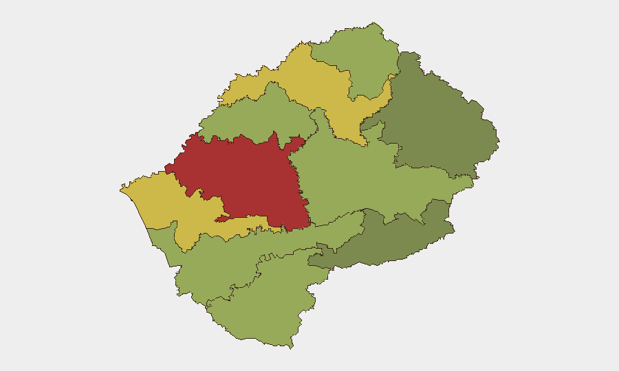
Maseru District (risk score 78) dominates the threat landscape, driven by its status as the capital, primary commercial hub, and principal entry point for cross-border criminal activity. Mafeteng (65) and Leribe (62) districts follow, likely reflecting proximity to South African borders and informal-economy populations vulnerable to trafficking and smuggling. The southern districts—Quthing (42) and Qacha's Nek (28)—show significantly lower scores, suggesting risk concentration in the western and northern border zones where Lesotho interfaces with South Africa's Free State and KwaZulu-Natal provinces.
How GeoBit Would Assist
Security teams managing personnel or assets in Lesotho should employ OSINT fusion and corroboration to track informal criminal networks operating across the Maseru–South African border corridor, coupled with network and actor analysis to map document-fraud and copper-theft supply chains. AOI monitoring and early warning on Maseru's port of entry and secondary crossings would provide persistent alerting on anomalous border activity or infrastructure targeting, while conflict, crime, and cyber search capabilities enable deeper investigation into cross-border financial flows and illicit arms movement enabled by weaker institutional oversight.
7-Day Outlook
Near-term trajectory remains stable, with no indicators of sudden destabilization. The formalization of INTERPOL cooperation suggests modest reduction in law-enforcement blind spots, though implementation will require time and resource deployment. Cross-border criminal networks and informal-economy vulnerabilities will persist as the dominant operational environment for expatriate security teams; border-adjacent operations should maintain heightened procedural vigilance regarding document verification and third-party contractor vetting.
Highest-Risk Areas — Ranked
| # | State / Region | Risk |
|---|---|---|
| 1 | Maseru District | 78 |
| 2 | Mafeteng District | 65 |
| 3 | Leribe District | 62 |
| 4 | Berea District | 58 |
| 5 | Mohale's Hoek District | 52 |
| 6 | Butha-Buthe District | 48 |
| 7 | Thaba-Tseka District | 45 |
| 8 | Quthing District | 42 |
| 9 | Mokhotlong District | 38 |
| 10 | Qacha's Nek District | 28 |
Sources
Previous Weekly Briefs
A new Lesotho brief is written every Monday, covering the week — each with its own risk map and downloadable CSV. Use the calendar to go further back.
- October 13, 2026
- October 6, 2026
- September 29, 2026
- September 22, 2026
- September 15, 2026
- September 8, 2026
- September 2, 2026
📅 Browse past briefs by calendar →
Highlighted days have a brief. Tap a day for that day's map & analysis, or “csv” for that day's dataset ($5).
Atlas — our AI intelligence desk — emails them this snapshot personally. Nothing else, no list.