Situation Summary
Bangladesh faces acute political and civil instability following a reported assassination of the Prime Minister on 25 July 2026, coupled with concurrent small-arms combat involving activist groups in Dhaka, student-led demonstrations, and military/paramilitary engagement. The event signals cluster—spanning parliamentary statements, armed clashes, arrests, and conventional military deployment—indicates a rapid deterioration in the security environment within the past 48 hours. Dhaka Division carries significantly elevated risk (33.8) relative to all other regions, reflecting the concentration of political, administrative, and security-force activity in the capital.
Key Developments
- Dhaka, nationwide — 25 July 2026 — Prime Minister assassinated; Armed Forces and activist groups engaged in small-arms combat; Parliament issued public statement and military force deployed against activists. Exact locations and casualty figures require real-time verification.
- Dhaka Division — 25 July 2026 — Student-led demonstrations escalated; multiple arrests by Bangladesh authorities reported; concurrent armed clashes between assailants and activists recorded across the division.
- School location (unspecified) — 23 July 2026 — Small-arms combat incident occurred on school premises; threat to educational facilities and civilian safety noted.
- Coast Guard operations — 24 July 2026 — Investigation initiated by Coast Guard; nature and location of incident not yet detailed in available reporting.
- Kushtia, Daumatpur border — 25 July 2026 — Border Guard Bangladesh intercepted eight unidentified individuals attempting unauthorized entry from Indian territory and forced them back across the border.
- Dhaka, Bhatara area — 25 July 2026 — Gas-line explosion killed two civilians (24-year-old male and 8-year-old female); third family member reported critical; infrastructure damage and potential ongoing gas-supply disruption.
- Khulna, Barishal, Chattogram divisions — 25 July 2026 — Bangladesh Meteorological Department issued heavy-to-very-heavy rainfall warning; concurrent flood-disruption reports from Rangamati (Sajek area, 400+ tourists stranded) and Cox's Bazar Ukhiya camp (hillside collapse, three student deaths reported 23 July).
Highest-Risk Areas
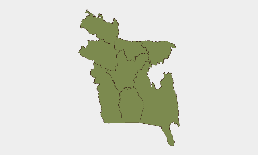
Dhaka Division dominates the risk profile at 33.8, driven by the concentration of government, security forces, and activist infrastructure. The capital is the epicenter of the assassination, armed clashes, and mass demonstrations; all other divisions cluster at 3.8–3.9, indicating Dhaka's exceptional risk elevation. Secondary concern attaches to Khulna and Barishal divisions, where concurrent heavy rainfall and flood displacement create compound risks (infrastructure failure, stranded populations, disease vectors). Rangamati and Cox's Bazar face acute humanitarian pressures from terrain-driven flooding and hillside collapse, compounding existing Rohingya-camp vulnerability and food-insecurity conditions affecting 15.3 million nationally.
How GeoBit Would Assist
Security teams should deploy AOI Monitoring & Early Warning on Dhaka Division and major protest/military congregation points; Network & Actor Analysis to map activist, political, and military-faction relationships and predict secondary escalation; and Intel Sweep combined with X/Twitter OSINT to surface real-time incident reporting, casualty counts, and curfew/closure declarations. Satellite & Imagery analysis and GIS mapping would establish cordon/exclusion zones and safe routing around active combat areas, while Routing & Network Analysis supports duty-of-care personnel extraction and supply-line continuity.
7-Day Outlook
Political instability and armed clashes are likely to persist or intensify over the next 7 days as power-succession and opposition-movement dynamics unfold; curfews, checkpoints, and military deployment will disrupt transport and commerce. Concurrent heavy rainfall increases flood risk and humanitarian need in southern and southeastern divisions. Evacuation, shelter-in-place, and contingency-response protocols should remain active.
Highest-Risk Areas — Ranked
| # | State / Region | Risk |
|---|---|---|
| 1 | Dhaka Division | 33.8 |
| 2 | Khulna Division | 3.9 |
| 3 | Barishal Division | 3.8 |
| 4 | Chittagong Division | 3.8 |
| 5 | Rangpur Division | 3.8 |
| 6 | Rajshahi Division | 3.8 |
| 7 | Mymensingh Division | 3.8 |
| 8 | Sylhet Division | 3.8 |
Sources
Previous Daily Briefs
A new Bangladesh brief is written every day — each with its own risk map and downloadable CSV. Here's the last week; use the calendar to go further back.
📅 Browse every day by calendar →
Highlighted days have a brief. Tap a day for that day's map & analysis, or “csv” for that day's dataset ($5).
Atlas — our AI intelligence desk — emails them this snapshot personally. Nothing else, no list.