Situation Summary
Barbados remains a low-threat environment with no validated acute security incidents reported in the last 24–48 hours. The national composite threat score remains at 3 globally (#182), and open-source monitoring confirms no active protest activity, infrastructure disruption, or crime surge. The security posture is stable, though localized risk concentrations in Saint Michael and Saint George parishes warrant continued awareness, particularly ahead of CARIFESTA XV (22–31 August).
Key Developments
- Barbados (national) — 14 Aug 2026: Open-source monitoring confirmed no acute security incidents, protest activity, or infrastructure disruption in the prior 48-hour window.
- Barbados (national) — 16 Aug 2026: Travel-safety index update maintained Barbados' low-risk rating with no specific incident cited.
- Bridgetown — 17 Aug 2026: Travel advisories noted upcoming CARIFESTA XV cultural festival (22–31 Aug), warning of elevated pedestrian crowding and potential transport strain in central business and entertainment districts; not a current security incident, but an operational planning factor.
- South coast (multiple parishes) — 18 Aug 2026: Routine road-safety and crosswalk repainting infrastructure maintenance ongoing; no unrest or disruption reported.
- Barbados (national) — 18 Aug 2026: Local broadcast coverage discussed non-traditional threats (gun violence, cyber threats, disinformation) in general terms; no new discrete incident identified or validated.
Highest-Risk Areas
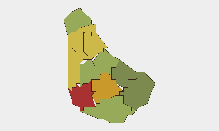
Saint Michael (risk 78) and Saint George (risk 72) drive the national risk profile and account for the majority of elevated concern. Both parishes contain or adjoin the capital Bridgetown and its commercial core, where population density, transient populations, and economic activity create routine friction points. Saint James (68) and Saint Andrew (65) follow, while remaining parishes fall progressively lower. The concentration of risk in the northwestern and central parishes reflects historical crime and social-cohesion patterns rather than acute current events; southern parishes (Saint Philip, Saint John) remain substantially lower-risk, as does the eastern corridor.
How GeoBit Would Assist
Corporate teams with personnel or assets in Barbados—especially in Saint Michael, Saint George, and central Bridgetown—should employ Intel Sweep and global event feeds to sustain real-time incident monitoring, paired with X/Twitter and Telegram OSINT to detect early warning signals of unrest, labor action, or crime spikes. AOI (Area-of-Interest) Monitoring & Early Warning on high-risk parishes and transport nodes (airport, port, CBD) enables persistent watch with automated alerting; GIS & Spatial Analysis supports alternative-route planning for staff movements during high-footfall periods such as CARIFESTA XV. Sentiment & temporal analysis of local media and social platforms provides early detection of emerging tensions or public-safety concerns.
7-Day Outlook
No material deterioration in the security environment is forecast over the next seven days. CARIFESTA XV (22–31 Aug) will increase transient populations and congestion in Bridgetown and Saint Michael, raising operational friction and minor incident risk (transport delays, pickpocketing, overcrowding) rather than organized crime or unrest. Duty-of-care teams should plan for routine precautions: staff briefings on festival crowds, adjusted travel windows, and enhanced situational awareness in central districts.
Highest-Risk Areas — Ranked
| # | State / Region | Risk |
|---|---|---|
| 1 | Saint Michael | 78 |
| 2 | Saint George | 72 |
| 3 | Saint James | 68 |
| 4 | Saint Andrew | 65 |
| 5 | Saint Peter | 62 |
| 6 | Saint Joseph | 58 |
| 7 | Saint Thomas | 52 |
| 8 | Saint Lucy | 48 |
| 9 | Christ Church | 42 |
| 10 | Saint John | 35 |
| 11 | Saint Philip | 28 |
Sources
Previous Daily Briefs
A new Barbados brief is written every day — each with its own risk map and downloadable CSV. Here's the last week; use the calendar to go further back.
- August 16, 2026
- August 14, 2026
- August 12, 2026
- August 10, 2026
- August 8, 2026
- August 6, 2026
- August 5, 2026
📅 Browse every day by calendar →
Highlighted days have a brief. Tap a day for that day's map & analysis, or “csv” for that day's dataset ($5).
Atlas — our AI intelligence desk — emails them this snapshot personally. Nothing else, no list.