Situation Summary
Belarus remains in a state of elevated but non-acute security tension, with a composite threat score of 7 and six tracked events. No major security, civil unrest, or infrastructure incidents were confirmed in the past 24–48 hours as of 5 August 2026. The most significant recent development—Latvia's proposed suspension of the Pāternieki border crossing on 3 August—introduces travel disruption risk and potential for escalation, while continued Russian UAV activity in Belarusian airspace signals ongoing militarization without reported combat impact.
Key Developments
- Latvia–Belarus border, Pāternieki crossing – 3 August 2026
Latvia's Interior Ministry announced a full suspension of passenger and freight traffic through the Pāternieki checkpoint, citing migration pressure and intelligence concerns. The Belarusian Foreign Ministry responded the same day with a threat of "asymmetric" retaliatory measures, escalating bilateral tensions and creating immediate uncertainty for cross-border transit.
- Belarusian airspace, multi-location – 27 July–2 August (reported 3 August)
Ten Russian unmanned aerial vehicles were recorded transiting Belarusian airspace during this period. The Belarusian Air Force scrambled quick-reaction aircraft for interception; no confirmed shoot-downs, crashes, or casualties were reported.
- No discrete security incidents confirmed for 4–5 August 2026
Open-source monitoring and regional security dashboards identified no verified major incidents—conflict, crime, civil unrest, or infrastructure disruption—in Belarus during the immediate 24–48 hour window of this brief.
*Note: Earlier developments (Malaryta district exercises on 29 July, Rainbow Family festival detentions in late July, and Ukrainian drone activity reports from early July) fall outside the 24–48 hour reporting window and are retained as context only.*
Highest-Risk Areas
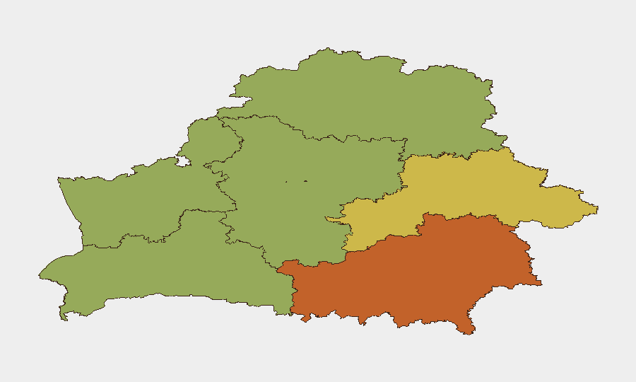
Homyel Region (Gomel), Minsk, and Mahilyow Region drive the sub-national risk ranking, with composite scores of 75, 68, and 62 respectively. Homyel's elevated risk reflects its proximity to the Russia–Ukraine theatre, ongoing Russian military presence, and intelligence/border activity. Minsk concentrates political control, state security apparatus, and diplomatic exposure, while Mahilyow's score reflects similar proximity to conflict zones and military infrastructure. Brest Region (55) shows elevated cross-border risk at the Polish frontier. Lower-risk regions (Vitsebsk, Minsk Region, Hrodna) remain monitored but do not currently drive national threat dynamics.
How GeoBit Would Assist
Security teams with personnel or assets in Belarus should employ AOI Monitoring & Early Warning to establish persistent surveillance of Homyel and Minsk, with automated alerting on border activity, military movements, and civil unrest. Multi-language OSINT (X/Twitter, Telegram, news feeds) combined with temporal and sentiment analysis provides early detection of regime statements, migration surges, or cross-border provocations—critical for duty-of-care decisions around the Pāternieki closure and potential spillover. Routing & Network Analysis can model alternative transit corridors in real time if border crossings are suspended, while conflict & military tracking monitors Russian force posture and UAV activity in Belarusian airspace to assess escalation risk.
7-Day Outlook
The Pāternieki closure announcement is likely to remain contentious through the coming week, with Belarusian statements and potential reciprocal border actions creating volatility in cross-border logistics and visa/transit processing. Persistent Russian UAV activity in Belarusian airspace is expected to continue at baseline levels without reported military escalation. No major civil, security, or infrastructure incidents are forecast for the next 7 days, though the border tension may indirectly affect business continuity and staff movement across the Belarus–Latvia frontier.
Highest-Risk Areas — Ranked
| # | State / Region | Risk |
|---|---|---|
| 1 | Homyel Region | 75 |
| 2 | Minsk | 68 |
| 3 | Mahilyow Region | 62 |
| 4 | Brest Region | 55 |
| 5 | Hrodna Region | 52 |
| 6 | Minsk Region | 48 |
| 7 | Vitsebsk Region | 45 |
Sources
Previous Daily Briefs
A new Belarus brief is written every day — each with its own risk map and downloadable CSV. Here's the last week; use the calendar to go further back.
📅 Browse every day by calendar →
Highlighted days have a brief. Tap a day for that day's map & analysis, or “csv” for that day's dataset ($5).
Atlas — our AI intelligence desk — emails them this snapshot personally. Nothing else, no list.