Situation Summary
Belize remains in a persistently elevated crime environment, with composite threat ranking at #96 globally (score 17), driven predominantly by gang and interpersonal violence rather than organized political instability or terrorism. Mid-August 2026 saw a cluster of fatal incidents—including homicides in Belize City and armed robbery on the George Price Highway—consistent with long-standing patterns of street crime and commercial-corridor vulnerability. No discrete security incidents have been confirmed in the 24–48 hours prior to 23 August 2026, though the absence of recent reporting does not indicate a reduction in underlying risk; baseline vulnerability remains high in urban and transit zones.
Key Developments
No confirmed security incidents dated 22–23 August 2026 are available from current open-source intelligence. The most recent credible events fall within the preceding week:
- 21 August 2026 – Armed robbery at Puma gas station, Philip Goldson Highway, Belize City; outside strict 48-hour window but relevant to commercial-corridor risk profile.
- 20 August 2026 – Truck driver shot during armed robbery, George Price Highway (primary commercial link between Belize City and interior); ongoing highway vulnerability.
- 18 August 2026 – Homicide of Tyrell Robinson (27, butcher), Jun's Meat Shop near Michael Finnegan Market, Belize City; reflects persistent urban gang/street violence.
- 18 August 2026 – Fatal traffic accident at Mile 27 (Biscayne Village), Belize City–Orange Walk highway; multi-hour police closure, secondary mobility impact.
- 12 August 2026 – Homicide of Jose Luis Arteaga (35, fisherman), stabbing aboard sailboat near Ranguana Caye; interpersonal violence extending to maritime zone.
Assessment: No escalation is evident in the last 24 hours; mid-August cluster may reflect seasonal or reporting variation rather than sudden spike.
Highest-Risk Areas
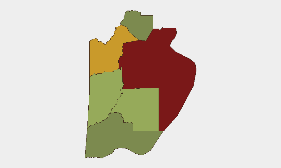
Belize District (composite risk 95) dominates the threat landscape, encompassing Belize City and surrounding commercial zones where homicide, armed robbery, and gang activity are concentrated. Orange Walk District (risk 72) and Cayo District (risk 58) present secondary but material risk, particularly along inter-district highways (George Price Highway, Belize City–Orange Walk corridor) where armed robbery and commercial-vehicle targeting occur. The Toledo, Stann Creek, and Corozal districts (composite risks 35, 48, 22 respectively) remain lower-risk, though not immune to spillover gang activity or rural interpersonal violence. Risk correlates primarily with urbanization, commercial traffic density, and gang territorial presence rather than political instability.
How GeoBit Would Assist
Corporate security and duty-of-care teams would employ AOI Monitoring & Early Warning (persistent watch on Belize District, George Price Highway, and key commercial nodes) coupled with Intel Sweep and multi-language OSINT (X/Twitter, local news outlets, police and hospital channels) to capture incident confirmation in real time, reducing reporting lag. Routing & Network Analysis supports alternative-journey planning for personnel and cargo transiting between Belize City and interior operations, identifying lower-risk corridors and timing windows. Risk & Threat Assessment and Entity/Network Analysis enable identification of gang territorial shifts and localized escalation signals before they manifest in multiple fatalities.
7-Day Outlook
Current trajectory suggests continuation of endemic street crime and commercial-corridor robbery without imminent organized escalation or political upheaval. Heightened vigilance is warranted through early September given typical mid- to late-summer gang activity patterns. Personnel and asset movements should remain routed through vetted, daylight-only corridors with security coordination.
Highest-Risk Areas — Ranked
| # | State / Region | Risk |
|---|---|---|
| 1 | Belize District | 95 |
| 2 | Orange Walk District | 72 |
| 3 | Cayo District | 58 |
| 4 | Stann Creek District | 48 |
| 5 | Toledo District | 35 |
| 6 | Corozal District | 22 |
Sources
Previous Daily Briefs
A new Belize brief is written every day — each with its own risk map and downloadable CSV. Here's the last week; use the calendar to go further back.
- August 21, 2026
- August 19, 2026
- August 17, 2026
- August 15, 2026
- August 13, 2026
- August 11, 2026
- August 9, 2026
📅 Browse every day by calendar →
Highlighted days have a brief. Tap a day for that day's map & analysis, or “csv” for that day's dataset ($5).
Atlas — our AI intelligence desk — emails them this snapshot personally. Nothing else, no list.