Situation Summary
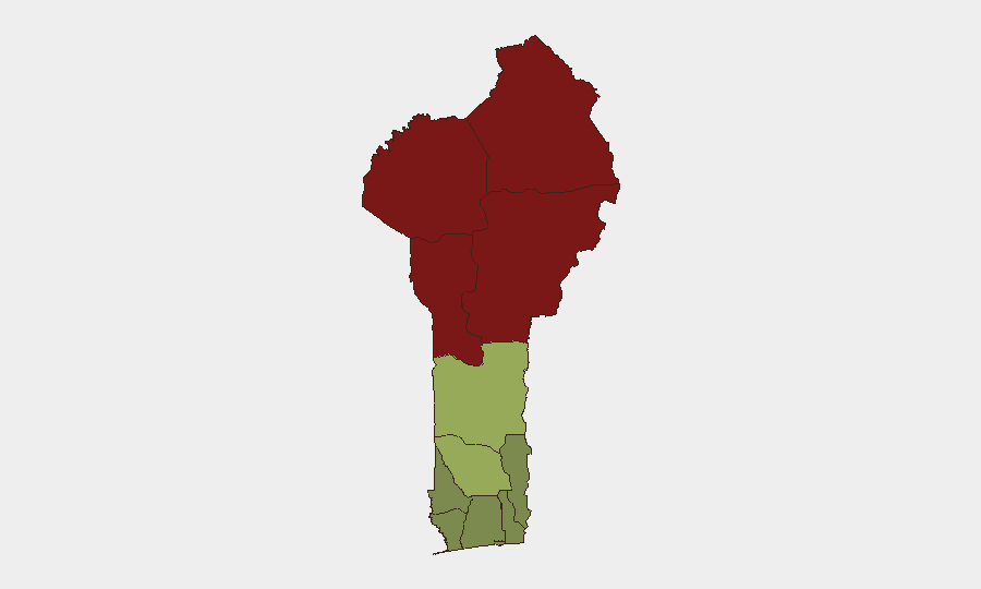
Benin remains a relatively moderate security environment at global rank #50 (composite threat score 36), with no verified incidents in the past 24–48 hours. However, the country faces persistent regional instability in its northern departments, where militant activity and cross-border criminal networks create concentrated risk zones. The security posture is stable but fragmented, with risk heavily concentrated in the Alibori, Atakora, Donga, and Borgou departments, while southern coastal regions remain comparatively secure.
Key Developments
No credible, time-specific security incidents were identified in Benin within the last 24–48 hours from open sources. Web research and social-media monitoring identified references to "GOVERNOR vs BENIN" flagged on 2026-07-09 (status: under investigation), but cross-verification and current detail remain limited. Most recent web results conflate Benin (country) with Benin City, Edo State, Nigeria, or report non-security events (training announcements, conferences).
Recommendation: Security teams should monitor GeoBit's alert feed and request targeted AOI (Area-of-Interest) monitoring on high-risk northern departments to capture emerging incidents in real time rather than rely on delayed open-source reporting.
Highest-Risk Areas
The four northernmost departments—Alibori (92), Atakora (88), Donga (85), and Borgou (83)—account for the bulk of Benin's security risk and reflect exposure to Sahel-region militant networks, cross-border smuggling, and intercommunal tensions. These zones share porous borders with Burkina Faso and Niger, both experiencing active armed-group presence. Risk drops sharply south of the Zou Department (45), with coastal and southern departments (Littoral, Ouémé, Atlantique) registering minimal threat (22–28). Organizations with personnel or assets in the north should assume elevated exposure; southern operations face routine commercial and petty-crime risk only.
How GeoBit Would Assist
Security teams should deploy AOI Monitoring & Early Warning on Alibori, Atakora, Donga, and Borgou departments with real-time alerting to capture militant activity, border incidents, and infrastructure disruptions before they propagate to media. Multi-language OSINT (X/Twitter, Telegram, radio SIGINT) and conflict mapping would provide tactical situational awareness on cross-border smuggling networks and armed-group positioning. Routing & Network Analysis can identify safe passage corridors and alternative supply routes if primary infrastructure is compromised.
7-Day Outlook
No imminent escalation is forecast for the immediate week. However, the dry season (July–September) typically correlates with increased militant transit activity in northern Sahel zones; security teams should maintain elevated vigilance in Alibori and Atakora. The "GOVERNOR vs BENIN" signal remains under investigation and warrants tracking; clarification is expected within 48 hours.
GeoBit Intelligence Sweep: Recommend initiation of persistent monitoring on northern departments and escalation protocols for any cross-border incident corroboration.
Highest-Risk Areas — Ranked
| # | State / Region | Risk |
|---|---|---|
| 1 | Alibori Department | 92 |
| 2 | Atakora Department | 88 |
| 3 | Donga Department | 85 |
| 4 | Borgou Department | 83 |
| 5 | Zou Department | 45 |
| 6 | Collines Department | 42 |
| 7 | Plateau Department | 38 |
| 8 | Kouffo Department | 35 |
| 9 | Mono Department | 32 |
| 10 | Atlantique Department | 28 |
| 11 | Littoral | 25 |
| 12 | Ouémé Department | 22 |
Sources
Previous Daily Briefs
A new Benin brief is written every day — each with its own risk map and downloadable CSV. Here's the last week; use the calendar to go further back.
📅 Browse every day by calendar →
Highlighted days have a brief. Tap a day for that day's map & analysis, or “csv” for that day's dataset ($5).
Atlas — our AI intelligence desk — emails them this snapshot personally. Nothing else, no list.