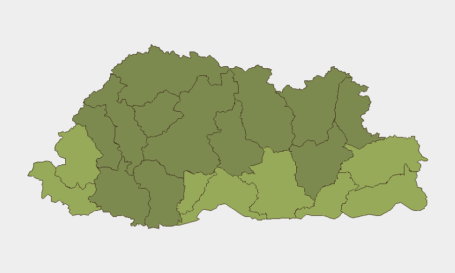
Situation Summary
Bhutan remains a low-threat environment with a composite national threat score of 4 and no confirmed security incidents, civil unrest, or crime events reported in the last 24–48 hours. Six tracked events are under monitoring, primarily concentrated in border districts and involving public statements and business-related developments. Overall security trajectory remains stable with localized administrative and electoral activity as primary signals.
Key Developments
- No confirmed security incidents nationwide (last 24–48 hours). Web research and event feeds returned no verified conflicts, crime, civil unrest, or infrastructure disruptions affecting Bhutan in the 24–48 hour window ending 2026-07-22.
- Samtse District elevated risk (risk score 58). Border district remains highest-risk sub-national location; no specific new incident confirmed but warrants continued AOI monitoring given proximity to India–Bhutan border and historical tension signals.
- Sarpang and Haa Districts elevated risk (scores 55, 52). Southern and northwestern border zones show elevated composite risk; underlying drivers not independently verified in last 24–48 hours but reflect persistent event clustering.
- Electoral and voter-engagement signals (Thimphu, 2026-07-20). Public statements and low voter turnout reported in local elections; not a security threat but indicates possible civic friction or administrative friction points.
- Business disapproval signal (2026-07-20). Unspecified business-related disapproval event logged; insufficient detail to assess operational impact on corporate operations.
- Regional diplomatic activity (2026-07-19). Public statements involving European, Hindu pilgrim, and Saudi Arabia actors detected; no confirmed local incident but suggests external-actor engagement or commentary on Bhutan.
- Ministerial and investigative signals (2026-07-19). Government investigations initiated; scope and subject undefined in available signals. Routine administrative activity cannot be ruled out.
Highest-Risk Areas
Samtse, Sarpang, Haa, and Pemagatshel districts comprise the top-risk tier (scores 48–58) and are concentrated in Bhutan's southern and northwestern border regions adjacent to India and Tibet. These zones historically experience elevated cross-border activity, informal trade, and periodic administrative friction. The risk ranking reflects event clustering and geopolitical sensitivity rather than active conflict; organizations with operations or staff in these districts should maintain heightened situational awareness and liaison with local authorities.
How GeoBit Would Assist
Security and duty-of-care teams should deploy AOI Monitoring & Early Warning on Samtse, Sarpang, and Haa districts to capture emerging unrest, administrative changes, or border friction in real time. Intel Sweep and multi-language OSINT (incorporating Dzongkha and regional social media) would provide independent corroboration of local incidents ahead of mainstream reporting. Risk & Threat Assessment and Network & Actor Analysis would clarify the business and diplomatic signals currently flagged as unspecified, supporting targeted response planning.
7-Day Outlook
No escalation is forecast over the next 7 days. Border districts will remain under watch for routine cross-border activity and administrative updates. Electoral cycles and business-sector developments may generate additional public statements but are unlikely to drive security incidents. Persistent monitoring of diplomatic activity and ministerial investigations is recommended to detect any shift in administrative posture or regional engagement.
Highest-Risk Areas — Ranked
| # | State / Region | Risk |
|---|---|---|
| 1 | Samtse District | 58 |
| 2 | Sarpang District | 55 |
| 3 | Haa District | 52 |
| 4 | Pemagatshel District | 50 |
| 5 | Samdrup Jongkhar District | 48 |
| 6 | Tsirang District | 45 |
| 7 | Zhemgang District | 42 |
| 8 | Trashigang District | 40 |
| 9 | Mongar District | 38 |
| 10 | Gasa District | 35 |
| 11 | Lhuntse District | 32 |
| 12 | Wangdue Phodrang District | 30 |
Sources
Previous Daily Briefs
A new Bhutan brief is written every day — each with its own risk map and downloadable CSV. Here's the last week; use the calendar to go further back.
📅 Browse every day by calendar →
Highlighted days have a brief. Tap a day for that day's map & analysis, or “csv” for that day's dataset ($5).
Atlas — our AI intelligence desk — emails them this snapshot personally. Nothing else, no list.