Situation Summary
Botswana remains a low-threat environment globally (composite threat score 3) with no tracked nationwide security or political-instability incidents. However, localized crime, inter-community tensions, and civil-order challenges—concentrated in peri-urban areas around Gaborone and Francistown—are creating elevated risk for specific populations and requiring targeted duty-of-care attention. The security picture is stable but fragmented, with crime and social friction concentrated in higher-density urban and informal-settlement zones rather than systemic instability.
Key Developments
- Mogoditshane robbery, Kweneng District (night of 1 August): Two individuals robbed at knifepoint while parked roadside; assailant stole belongings and vehicle, later recovered abandoned in Gaborone. Indicative of opportunistic violent crime in peri-urban settings.
- Inter-community tensions, Mogoditshane (late July–2 August escalation): Police report escalating violent clashes between Batswana and Zimbabwean nationals attributed to rising crime; authorities express concern for further civil disturbance and inter-community violence into the weekend.
- Kweneng Land Board eviction notices (1–2 August): 420 informal settlers in Mogoditshane summoned for formal eviction proceedings; development likely to increase local social tension and risk of small-scale confrontations over land and housing.
- Fatal traffic accident, Tatitown, Francistown (morning of 1 August): 39-year-old died in truck-collision incident; reflects ongoing road-safety hazards on urban approaches to Francistown.
- Unexplained child death, Boswelakgosi lands, Gaborone outskirts (1 August morning): Three-month-old found unresponsive; police investigating circumstances, raising child-safety concerns in rural-adjacent areas.
- Death in pond, Ramokgonami village, Central District (1 August): Missing 36-year-old found dead in mogobe (village pond); police investigating cause and possibility of foul play.
Highest-Risk Areas
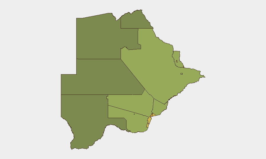
Gaborone (risk 72) and South-East District (68) anchor the highest-risk tier, driven by concentration of urban crime, informal settlement friction, and inter-community tensions. Lobatse (65), Francistown (62), and Jwaneng (61) follow, with Francistown notably affected by road-safety incidents and peri-urban crime. Mid-tier risk zones (Selebi Phikwe, Southern District, Kgatleng) reflect secondary urban and informal-settlement dynamics. The pattern reflects crime and social pressure concentrated in economic and population centers rather than rural or remote areas; northern and western districts remain substantially lower-risk.
How GeoBit Would Assist
Security and risk teams with personnel or assets in Gaborone, Mogoditshane, or Francistown would deploy AOI Monitoring & Early Warning on these high-friction zones to track evolving inter-community tensions, informal-settlement eviction activity, and violent-crime clusters in near-real time. Intel Sweep and multi-language OSINT fusion (X/Twitter, local news, police statements, community networks) would provide 24–48-hour lead on localized incidents before they escalate to broader civil unrest. Routing & Network Analysis would enable security teams to identify safer travel corridors around known robbery and accident hotspots, particularly in Mogoditshane and Tatitown approaches.
7-Day Outlook
Near-term risk trajectory is likely stable but localized. Mogoditshane eviction proceedings (expected to continue over the coming week) may generate short-term social friction and small-scale confrontations; inter-community tensions remain a flashpoint for isolated violence but show no sign of coalescing into widespread unrest. Road-safety incidents and opportunistic urban crime are expected to persist at current baseline levels; no nationwide political or security shocks are anticipated.
Highest-Risk Areas — Ranked
| # | State / Region | Risk |
|---|---|---|
| 1 | Gaborone | 72 |
| 2 | South-East District | 68 |
| 3 | Lobatse | 65 |
| 4 | Francistown | 62 |
| 5 | Jwaneng | 61 |
| 6 | Selebi Phikwe | 58 |
| 7 | Southern District | 55 |
| 8 | Kgatleng District | 50 |
| 9 | Kweneng District | 48 |
| 10 | North-East District | 45 |
| 11 | Central District | 42 |
| 12 | North-West District | 38 |
Sources
Previous Daily Briefs
A new Botswana brief is written every day — each with its own risk map and downloadable CSV. Here's the last week; use the calendar to go further back.
📅 Browse every day by calendar →
Highlighted days have a brief. Tap a day for that day's map & analysis, or “csv” for that day's dataset ($5).
Atlas — our AI intelligence desk — emails them this snapshot personally. Nothing else, no list.