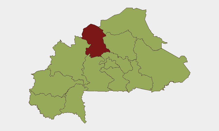
Situation Summary
Burkina Faso remains at elevated composite threat level (#29 globally, score 80) amid an ongoing jihadist insurgency, compounded by acute diplomatic rupture with France completed on 12–13 July 2026. The North region presents the highest sub-national risk (86.1), while most other zones cluster at moderate-high risk (56.1). No specific, location-verified attacks were reported in the past 48 hours; however, absence of reporting does not indicate operational pause, and the security environment remains volatile across northern and eastern regions where armed groups operate with impunity.
Key Developments
- Ouagadougou – 12–13 July 2026: France completed withdrawal of all remaining diplomats following Burkina Faso's decision to sever diplomatic relations. The pullout, finalized "late last week" and publicly confirmed Monday, removes official French consular and embassy presence.
- Paris – 12 July 2026: Burkina Faso's diplomatic staff in France received notice of expulsion within seven days, in reciprocity for Ouagadougou's June 26 decision to cut bilateral ties. French Foreign Ministry disclosed the measure on Monday.
- Bilateral Expulsion Event – 12 July 2026: Formal collapse of France–Burkina Faso diplomatic relations confirmed via mutual expulsion of diplomatic personnel, marking full bilateral break.
- National Security Posture – Last 48 hours: No well-corroborated, location-specific armed attacks, clashes, or infrastructure incidents reported in open sources for 10–13 July 2026, though this reflects reporting availability rather than absence of insurgent activity.
- Counter-Insurgency Operations – Background context (30 June–3 July 2026, cited prominently in recent commentary): Burkinabè forces reported killing more than 400 militants and seizing 250+ motorbikes and 353 weapons following coordinated insurgent attacks on Gayéri (East), Solhan, and Sebba (Sahel); 3 soldiers confirmed killed. While events themselves predate the 48-hour window, they continue shaping current military operations and threat assessments.
Highest-Risk Areas
The North region stands distinctly elevated (86.1) due to sustained jihadist presence, porous borders with Mali, and repeated insurgent operations. The remaining ten regions cluster at 56.1, indicating that risk is geographically distributed across most of the country rather than concentrated in one zone. Upper-Basins, Boucle du Mouhoun, Central zones, Sahel, and East regions all face similar moderate-to-high threat from armed groups. This broad-based risk pattern reflects the fragmented, multi-group nature of the insurgency and limited state control in non-urban areas.
How GeoBit Would Assist
Security teams protecting personnel or assets in Burkina Faso should deploy AOI Monitoring & Early Warning capabilities to establish persistent watch over high-risk regions (North, East, Sahel), with alerting configured for armed-group activity, roadblocks, and military operations. Conflict & Military analysis (force-structure tracking, battle mapping) combined with Network & Actor Analysis enables tracking of jihadist group movements, leadership changes, and tactical shifts. Routing & Network Analysis supports development of safer alternative routes for personnel movement, while OSINT fusion (multi-language feeds, Telegram/X monitoring, radio SIGINT) maintains real-time awareness of diplomatic escalation, curfews, and localized incidents not yet in mainstream media.
7-Day Outlook
The collapse of France–Burkina relations is unlikely to trigger immediate security incident but will degrade crisis-response capacity for French nationals and complicate Western NGO operations. The junta's anti-French posture may harden further, potentially affecting visa, consular, and evacuation protocols. Insurgent operations in the North and East will continue at baseline operational tempo; no significant tactical escalation is indicated in the near term, but the absence of recent reporting should not be read as diminished threat.
Highest-Risk Areas — Ranked
| # | State / Region | Risk |
|---|---|---|
| 1 | North | 86.1 |
| 2 | Upper-Basins | 56.1 |
| 3 | Boucle du Mouhoun | 56.1 |
| 4 | Central-West | 56.1 |
| 5 | Central-South | 56.1 |
| 6 | Central-East | 56.1 |
| 7 | Waterfalls | 56.1 |
| 8 | Southwest | 56.1 |
| 9 | Sahel | 56.1 |
| 10 | Central-North | 56.1 |
| 11 | East | 56.1 |
| 12 | Centre | 56.1 |
Sources
Previous Daily Briefs
A new Burkina Faso brief is written every day — each with its own risk map and downloadable CSV. Here's the last week; use the calendar to go further back.
📅 Browse every day by calendar →
Highlighted days have a brief. Tap a day for that day's map & analysis, or “csv” for that day's dataset ($5).
Atlas — our AI intelligence desk — emails them this snapshot personally. Nothing else, no list.