Situation Summary
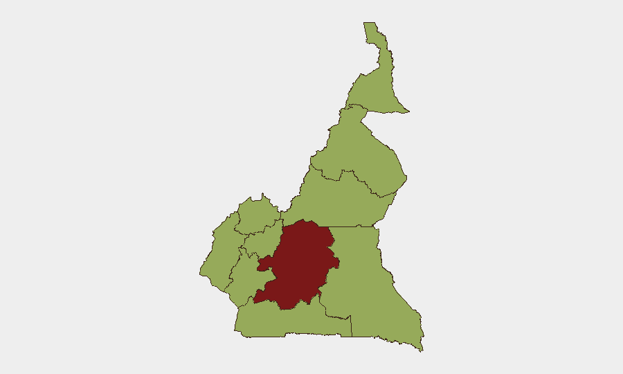
Cameroon maintains a composite threat ranking of #30 globally with a score of 74, reflecting persistent security fragmentation across multiple regions rather than a single national crisis. The Centre region (Yaoundé area) carries markedly elevated risk (81.7) compared to all other provinces, which cluster at moderate-to-equal levels (51.7). Current open-source reporting does not indicate acute incident activity in the 24–48 hour window, though underlying structural tensions in conflict-affected zones remain elevated.
Key Developments
- 2026-06-29 · Threat to Authorities (National). Signal indicates threat directed at state institutions; no specific location, target, or operational detail confirmed in public reporting. Timeframe and perpetrator remain unspecified in available sources.
- 2026-06-28 · Investigation Launched (National). Investigative action by competent authority; scope, location, and subject matter not yet detailed in cross-confirmed reporting.
- No verified security incidents (shooting, riot, abduction, infrastructure attack, or civil unrest) have been corroborated across independent sources for 27–28 June 2026. Local media, diaspora social-media channels, and international travel-advisory feeds contain no incident-specific reporting dated within the last 48 hours.
- Broader context (since early 2026): Far-North, Northwest, and Southwest regions continue to experience episodic armed-group activity, kidnapping, and communal violence; however, no new escalation has been confirmed in the immediate reporting window.
Highest-Risk Areas
Centre region (primarily Yaoundé and surrounding administrative zones) drives the national risk composite at 81.7—significantly above all other provinces. This concentration reflects capital-city institutional risk, potential political instability signals, and administrative/security-force activity. The remaining nine regions cluster uniformly at 51.7, indicating that while Far-North, Northwest, and Southwest historically experience the highest *operational* conflict intensity (armed groups, kidnapping networks), the current GeoBit composite weighting reflects broader structural or institutional vulnerabilities across the Centre. Security teams should treat Centre as the primary flag for near-term institutional or political developments; field teams in conflict-affected zones (Northwest, Southwest, Far-North) should maintain baseline protocols for armed-group and criminal activity.
How GeoBit Would Assist
Teams should deploy AOI Monitoring & Early Warning on Centre region (Yaoundé) to flag and alert on institutional, protest, or security-force activity in real time. Concurrently, multi-language OSINT (X/Twitter, Telegram, local media feeds, YouTube) with sentiment and temporal analysis would surface emerging incidents or threat narratives before they reach mainstream wire services. For field-asset routing and force-structure awareness, Routing & Network Analysis and Conflict & Military (force-structure, weapons-capability tracking) provide operational intelligence on armed-group disposition in Far-North and Northwest, supporting duty-of-care decisions for personnel movement.
7-Day Outlook
No acute escalation is signaled in current open-source reporting; however, the two institutional signals dated 28–29 June merit continued monitoring. If the "threat to authorities" signal reflects political or governance tension, secondary reporting may emerge within 72 hours. Field security posture in conflict-affected zones should remain at baseline vigilance; any unusual armed-group or kidnapping activity in Northwest or Southwest should trigger immediate team check-ins and route review.
Highest-Risk Areas — Ranked
| # | State / Region | Risk |
|---|---|---|
| 1 | Centre | 81.7 |
| 2 | Northwest | 51.7 |
| 3 | Southwest | 51.7 |
| 4 | West | 51.7 |
| 5 | Littoral | 51.7 |
| 6 | Adamawa | 51.7 |
| 7 | South | 51.7 |
| 8 | Far-North | 51.7 |
| 9 | North | 51.7 |
| 10 | East | 51.7 |
Sources
Previous Daily Briefs
A new Cameroon brief is written every day — each with its own risk map and downloadable CSV. Here's the last week; use the calendar to go further back.
📅 Browse every day by calendar →
Highlighted days have a brief. Tap a day for that day's map & analysis, or “csv” for that day's dataset ($5).