Situation Summary
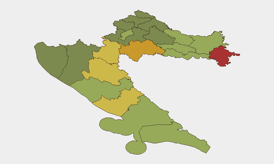
Croatia remains a low-threat environment globally (rank #177, composite score 3) with modest recent event activity (12 tracked signals). However, sub-national risk is concentrated in eastern and southern border counties—particularly Vukovar-Srijem, Sisak-Moslavina, and Karlovac—where historical tensions and infrastructure vulnerabilities sustain elevated exposure. Current developments are localized and non-systemic; nationwide weather hazards are the most acute near-term risk factor.
Key Developments
- Nationwide, 19 Jul 2026 — Croatian meteorological authorities elevated severe weather warnings across the country, with inland storm activity and coastal heat reaching 35°C; localized flooding and heat-stress incidents are possible through the weekend.
- Novi Vinodolski (Primorje-Gorski Kotar County), 19 Jul 2026 — Two medical students employed seasonally in hospitality were physically assaulted; local police involvement reported but incident scale and perpetrator profile remain unclear from available sources.
- Zagreb (City of Zagreb), 19 Jul 2026 — Administrative sanctions were issued against a hospital; cause and scope unconfirmed from current reporting.
- Multiple locations, 17–19 Jul 2026 — Four employer-linked investigations and one police investigation initiated; three separate incidents flagged for unconventional violence and public statements between Lazio entity and Croatian nationals; specific locations and injury counts not yet available in open reporting.
- Zagreb Region, 17 Jul 2026 — Incident involving Croatian national(s) and school reported; classification as unconventional violence noted but context insufficient from available intelligence.
Highest-Risk Areas
Eastern border counties dominate the sub-national ranking, with Vukovar-Srijem (78), Sisak-Moslavina (72), and Karlovac (68) leading. These regions face legacy post-conflict vulnerabilities, cross-border smuggling routes, and sporadic inter-ethnic friction. Lika-Senj (65) and Šibenik-Knin (62) in the southern interior and Adriatic zones show elevated scores tied to organized crime activity and seasonal migrant-labor friction. Zagreb and major coastal cities (Split-Dalmatia, Zadar) remain moderate-risk, driven chiefly by petty crime and seasonal tourism fluctuations rather than organized threats.
How GeoBit Would Assist
Corporate security and duty-of-care teams operating in Croatia should deploy AOI Monitoring & Early Warning on Vukovar-Srijem, Sisak-Moslavina, and Karlovac counties to catch emerging labor disputes, cross-border incidents, or criminal activity before escalation. OSINT Fusion & Corroboration (X/Twitter, Telegram, local news aggregation) on employer-linked violence and school incidents would clarify perpetrator motivation, organizational links, and copycat risk. Routing & Network Analysis is critical for staff or supply chains transiting eastern counties or the coast during high-heat weather windows to avoid flash-flood zones and heat-stress hotspots.
7-Day Outlook
Weather hazards will remain the primary near-term operational risk through 22 July, with secondary concern for heat-related medical incidents on the coast and localized flooding inland. The cluster of employer and police investigations (17–19 Jul) is under-reported; if correlated incidents emerge in hospitality, education, or NGO sectors, attention to migrant-labor and anti-social-behavior patterns will be warranted. Overall threat trajectory remains stable; no escalation indicators detected.
Highest-Risk Areas — Ranked
| # | State / Region | Risk |
|---|---|---|
| 1 | Vukovar-Srijem County | 78 |
| 2 | Sisak-Moslavina County | 72 |
| 3 | Karlovac County | 68 |
| 4 | Lika-Senj County | 65 |
| 5 | Šibenik-Knin County | 62 |
| 6 | Brod-Posavina County | 58 |
| 7 | Zadar County | 55 |
| 8 | Osijek-Baranja County | 52 |
| 9 | City of Zagreb | 50 |
| 10 | Split-Dalmatia County | 48 |
| 11 | Požega-Slavonia County | 45 |
| 12 | Virovitica-Podravina County | 42 |
Sources
Previous Daily Briefs
A new Croatia brief is written every day — each with its own risk map and downloadable CSV. Here's the last week; use the calendar to go further back.
📅 Browse every day by calendar →
Highlighted days have a brief. Tap a day for that day's map & analysis, or “csv” for that day's dataset ($5).
Atlas — our AI intelligence desk — emails them this snapshot personally. Nothing else, no list.