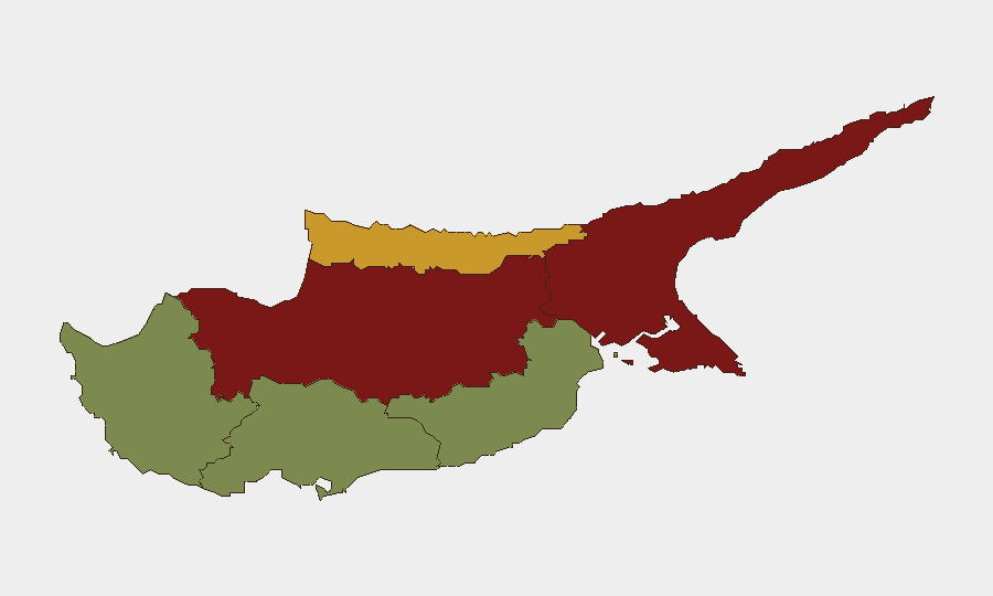
Situation Summary
Cyprus remains a low-threat environment globally (composite score 3), but sub-national variation is marked: the divided capital and northern corridor present substantially elevated risk, while southern and western coastal zones are comparatively secure. A shooting incident in Nicosia's Athalassa area on 4 August and a violent robbery in Limassol on the same evening signal continued street-level crime; routine police operations across the island on 3–5 August resulted in six arrests and 247 traffic offences, reflecting active enforcement but no systemic destabilization. The threat trajectory remains stable with localized, incident-driven volatility rather than escalating organized activity.
Key Developments
- Nicosia (Athalassa district) – Tue, 4 Aug, 2026: Shots fired at a moving vehicle in an incident police are treating as an attempted murder; ballistic evidence is under examination. This represents the highest-severity incident in the current reporting window.
- Limassol – Wed evening, 4 Aug, 2026: A 23-year-old food delivery rider was robbed and beaten by unknown assailants; police opened a criminal investigation on 5 Aug. The incident underscores street-level robbery risk in the southern commercial zone.
- Famagusta district (Deryneia crossing) – Mon, 3 Aug, 2026: Customs officers impounded a vehicle and seized smuggled tobacco at a border checkpoint, reflecting ongoing contraband activity in the northern districts.
- Nationwide operations – overnight 3–4 Aug and 4–5 Aug, 2026: Police conducted coordinated road-safety and crime-prevention sweeps, resulting in ten arrests, 247 traffic-offence reports, and two positive preliminary drug screenings across two nights. This indicates sustained police presence but no new criminal networks or disorder.
- Marathounta, Paphos district – Fri, 31 Jul, 2026 (reported within last 48 hours): Four workers injured in a workplace accident involving a road-construction machine; investigation ongoing. This is a safety incident, not a security threat.
Highest-Risk Areas
Nicosia (risk 92) and Famagusta (risk 88) drive the island's composite threat profile, driven by the unresolved political partition, smuggling networks, and sporadic street violence. The attempted shooting in Nicosia's Athalassa area on 4 August exemplifies localized lethal risk in the capital; Famagusta's contraband interdiction reflects organized criminality tied to the border environment. Kyrenia (risk 72) shares similar partition-related pressures. Southern zones—Limassol (22), Paphos (18), and Larnaca (28)—present lower but non-zero baseline risk; the Limassol robbery illustrates that opportunistic street crime is present but not systematic. Corporate assets and personnel in Nicosia should apply heightened situational awareness; southern operations face standard urban crime precautions.
How GeoBit Would Assist
Intel Sweep and multi-language OSINT on Telegram, X, and local news feeds would flag emerging crime clusters or organized activity before police disclosure. AOI Monitoring & Early Warning with persistent watch on Nicosia, Famagusta, and Limassol commercial zones would alert to repeat incidents or escalation patterns. GIS & Spatial Analysis would map robbery, weapons, and smuggling hotspots to guide personnel routing and asset positioning. Risk & Threat Assessment fusion of police activity, customs data, and local reporting would track whether street violence or border contraband reflect isolated acts or organized networks.
7-Day Outlook
No escalation of violence or organized crime is forecast over the next seven days. Routine police enforcement will likely continue; border smuggling operations should be monitored as a chronic rather than acute risk. Personnel and asset security teams should maintain standard precautions in Nicosia and northern zones while treating southern and western areas as lower-risk; incident-specific alert protocols remain appropriate.
Highest-Risk Areas — Ranked
| # | State / Region | Risk |
|---|---|---|
| 1 | Nicosia | 92 |
| 2 | Famagusta | 88 |
| 3 | Kyrenia | 72 |
| 4 | Larnaca | 28 |
| 5 | Limassol | 22 |
| 6 | Paphos | 18 |
Sources
Previous Daily Briefs
A new Cyprus brief is written every day — each with its own risk map and downloadable CSV. Here's the last week; use the calendar to go further back.
📅 Browse every day by calendar →
Highlighted days have a brief. Tap a day for that day's map & analysis, or “csv” for that day's dataset ($5).
Atlas — our AI intelligence desk — emails them this snapshot personally. Nothing else, no list.