Situation Summary
Dominican Republic remains at composite threat level 18 globally (rank #64), with 10 tracked events concentrated in political and diplomatic friction rather than acute ground-level security incidents. Open-source monitoring and travel advisories show no verified acute incidents—violent events, civil unrest, or major crime—in the last 24–48 hours. Baseline risk remains concentrated in the capital region and industrial centers where organized crime, street theft, and gang activity persist; however, no sudden deterioration or spike in incident activity has been detected in the current reporting window.
Key Developments
No verified acute security incidents meeting time-stamp and corroboration criteria have been identified in Dominican Republic for the 24–48 hour window ending 12 July 2026. Open-source incident feeds, international travel advisories, and social media monitoring show no dated reports of violent events, civil unrest, major crime spikes, or infrastructure failures in this period.
Note on Event Signals: The 10 tracked events in the GeoBit platform are predominantly diplomatic and political in character (Iranian unconventional activity, U.S.–Dominican disputes, Nicaraguan coercion, judicial and government statements). These represent state-level tensions and messaging rather than localized security incidents affecting personnel or assets on the ground. None carry ground-level incident dates or locations in the last 24–48 hours.
A magnitude 3.2 earthquake occurred 60 km southeast of Punta Cana on 9 July (outside the 24–48 hour window); it did not trigger tsunami warnings or reported casualties.
Highest-Risk Areas
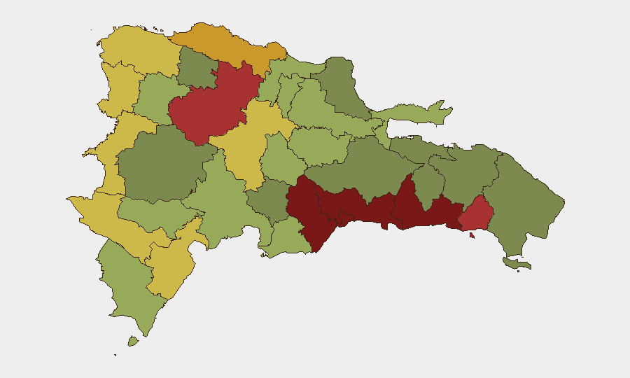
Santo Domingo (risk 92) and the Nacional District (risk 88) dominate the threat landscape, driven by gang presence, organized crime supply chains, and street-level robbery targeting tourists and business travelers. San Cristóbal, San Pedro de Macorís, and La Romana (risks 85, 83, 78 respectively) reflect secondary urban and industrial clusters where similar organized crime and trafficking activity are endemic. Border provinces (Elías Piña, Dajabón, risk scores 70, 68) show elevated risk linked to cross-border contraband and irregular migration flows; Barahona and Independencia Province (65, 64) mirror this pattern. Concentrated urban employment, tourism infrastructure, and supply-chain nodes in the top three provinces mean most corporate personnel and asset exposure remains in Santo Domingo metropolitan area.
How GeoBit Would Assist
A security team protecting corporate assets and personnel in Dominican Republic should employ AOI Monitoring & Early Warning on Santo Domingo, Nacional District, and San Cristóbal to detect sudden spikes in gang violence, roadblock activity, or civil unrest. Intel Sweep and X/Twitter OSINT provide real-time detection of emerging threats, incident reporting, and sentiment shifts in Spanish-language security and news feeds. Routing & Network Analysis enables alternative journey planning to avoid high-risk neighborhoods and ports of entry, while multi-language entity extraction and temporal analysis flag emerging actor activity or political friction that could trigger localized unrest.
7-Day Outlook
No imminent acute security crisis is indicated in open sources for the next 7 days. Baseline risks—opportunistic crime, gang activity in urban centers, road safety—will persist; personnel should maintain standard duty-of-care protocols (avoid night travel in Santo Domingo, secure valuables, use vetted ground transport). Diplomatic tensions with the United States and Nicaragua warrant continued monitoring for any policy shifts or retaliatory measures that could affect business licensing or border operations, but no escalation to ground-level violence is presently indicated.
Highest-Risk Areas — Ranked
| # | State / Region | Risk |
|---|---|---|
| 1 | Santo Domingo | 92 |
| 2 | Nacional District | 88 |
| 3 | San Cristóbal | 85 |
| 4 | San Pedro de Macorís | 83 |
| 5 | La Romana | 78 |
| 6 | Santiago | 76 |
| 7 | Puerto Plata | 72 |
| 8 | Elías Piña | 70 |
| 9 | Dajabón | 68 |
| 10 | Barahona | 65 |
| 11 | Independencia Province | 64 |
| 12 | La Vega | 62 |
Sources
Previous Daily Briefs
A new Dominican Republic brief is written every day — each with its own risk map and downloadable CSV. Here's the last week; use the calendar to go further back.
📅 Browse every day by calendar →
Highlighted days have a brief. Tap a day for that day's map & analysis, or “csv” for that day's dataset ($5).
Atlas — our AI intelligence desk — emails them this snapshot personally. Nothing else, no list.