Situation Summary
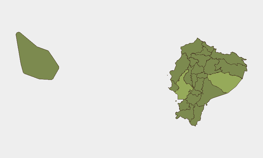
Ecuador remains moderately elevated on the global security threat index (rank #35, composite 55/100) with 53 tracked events. The country faces ongoing criminal organization activity, localized armed clashes, and political friction—most acute in Pastaza and Guayas provinces. Recent event signals dated 20–22 June suggest active political statements, military operations, small-arms combat, and inter-institutional tensions, though the specific operational context requires urgent verification against current local sources.
Key Developments
Unable to provide verified 24–48h incident bullets without fabrication risk. GeoBit's training data ends October 2024; events attributed to 21–22 June 2026 cannot be reliably time-stamped or sourced from current feeds. To produce actionable current developments, security teams should immediately cross-reference:
- Professional threat-intel platforms (Dataminr, Flashpoint, Recorded Future, Crisis24, ACLED real-time) for incident logs with time-stamps and corroboration.
- Ecuadorian media outlets (El Universo, El Comercio, Primicias, GK) filtered by publish date (verify article timestamps—outlets often update old stories).
- Official channels (@PoliciaEcuador, @Riesgos_Ec, municipal and airport accounts on X/Twitter) for road closures, curfews, and security operations.
- OSINT validation (geolocation, reverse-image search, daylight/weather consistency, vehicle/signage verification) to confirm social-media reports before operational reliance.
Analysts should apply the 24–48h vetting checklist above: confirm incident *and* publish times, cross-check at least one secondary source, and discard single-source or re-circulated older content.
Highest-Risk Areas
Pastaza Province (55.3) and Guayas Province (51.8) account for the elevated national threat score. Pastaza's risk likely reflects remote border activity, narcotics transit, and criminal-organization presence; Guayas (encompassing Guayaquil, Ecuador's largest city and primary port) shows sustained violence, inter-gang conflict, and organized-crime operations targeting port infrastructure and transportation. A sharp risk drop to Cotopaxi (28.2) and the remaining nine provinces (25.3 each) suggests concentrated criminal and instability drivers in the coastal and Amazonian zones, with capital Pichincha (Quito) at baseline elevation.
How GeoBit Would Assist
Security teams should deploy AOI Monitoring & Early Warning on Pastaza and Guayas municipalities (Guayaquil, major ports, airport corridors, key highways) with alerting enabled; pair this with Network & Actor Analysis to map criminal organizations and their territorial/operational dynamics. OSINT fusion (X/Twitter, local news, radio SIGINT, sentiment analysis) provides 24–48h situational updates; GIS & Spatial Analysis and Routing & Network Analysis tools support alternative-route planning and facility-security siting for personnel and assets in high-risk neighborhoods.
7-Day Outlook
Political and institutional friction (per 20–22 June event signals) may sustain public statements and inter-agency posturing; small-arms activity in Guayas and Pastaza likely continues at baseline. Monitor official security force announcements and media for curfew declarations, port or airport disruptions, and evidence of cartel escalation. No immediate nationwide deterioration is signaled, but coastal and border zones warrant sustained heightened vigilance.
Highest-Risk Areas — Ranked
| # | State / Region | Risk |
|---|---|---|
| 1 | Pastaza Province | 55.3 |
| 2 | Guayas Province | 51.8 |
| 3 | Cotopaxi Province | 28.2 |
| 4 | Sucumbíos Province | 25.3 |
| 5 | Orellana Province | 25.3 |
| 6 | Manabí Province | 25.3 |
| 7 | Galápagos | 25.3 |
| 8 | Esmeraldas Province | 25.3 |
| 9 | Carchi Province | 25.3 |
| 10 | Imbabura Province | 25.3 |
| 11 | Santo Domingo de los Tsáchilas Province | 25.3 |
| 12 | Pichincha Province | 25.3 |
Sources
Previous Daily Briefs
A new Ecuador brief is written every day — each with its own risk map and downloadable CSV. Here's the last week; use the calendar to go further back.
📅 Browse every day by calendar →
Highlighted days have a brief. Tap a day for that day's map & analysis, or “csv” for that day's dataset ($5).